
Mato Grosso do Sul facts for kids
Quick facts for kids
State of Mato Grosso do Sul
|
|||
|---|---|---|---|
|
|||

Location of State of Mato Grosso do Sul in Brazil
|
|||
| Country | |||
| Capital and Largest City | Campo Grande | ||
| Area | |||
| • Total | 357,124.962 km2 (137,886.719 sq mi) | ||
| Area rank | 6th | ||
| Population
(2012)
|
|||
| • Total | 2,505,088 | ||
| • Rank | 21st | ||
| • Density | 7.0145979/km2 (18.167725/sq mi) | ||
| • Density rank | 20th | ||
| Demonym(s) | Sul-mato-grossense or Mato-grossense-do-sul | ||
| GDP | |||
| • Year | 2010 estimate | ||
| • Total | R$ 38.484,74 (17th) | ||
| • Per capita | R$ 10,599 (11th) | ||
| HDI | |||
| • Year | 2005 | ||
| • Category | 0.810 – high (8th) | ||
| Time zone | UTC-4 (BRT-1) | ||
| • Summer (DST) | UTC-3 (BRST-1) | ||
| Postal Code |
79000-000 to 79990-000
|
||
| ISO 3166 code | BR-MS | ||
| Website | ms.gov.br | ||


Mato Grosso do Sul is one of the states in Brazil. It is located in the western part of the country. This state shares its borders with several other Brazilian states. These include Mato Grosso, Goiás, Minas Gerais, São Paulo, and Paraná. To the west, it also borders the countries of Paraguay and Bolivia. The capital city of Mato Grosso do Sul is Campo Grande.
The name "Mato Grosso do Sul" means "Southern Thick Forest". It got this name because it was once part of the larger state of Mato Grosso. The two states were separated in the 1970s. Sometimes, people mistakenly call Mato Grosso do Sul just "Mato Grosso". Because of this, there was a thought to change its name to "Pantanal". The Pantanal is the world's largest wetlands area, and a big part of it is in this state.
Contents
What is the Economy of Mato Grosso do Sul Like?
The economy of Mato Grosso do Sul mainly relies on farm products. Raising Cattle is the most important farming activity in the state. Other important farm products include sugarcane, wheat, and soybeans. Farmers also grow manioc, rice, and cotton.
Where is Mato Grosso do Sul Located?
Mato Grosso do Sul is in western Brazil. A large part of the state is covered by the Pantanal, which is a huge area of marshes.
The state is divided into 11 main areas. It also has 78 smaller areas called municipalities. Here are some of the larger cities in Mato Grosso do Sul:
- Campo Grande, which is the capital city.
- Corumbá
- Aquidauana
- Três Lagoas
- Naviraí
- Nova Andradina
- Paranaíba
- Dourados
- Ponta Porã
- Bonito
The highest point in the state is a mountain called Morro Grande. It is 1,065 meters (about 3,494 feet) tall.
When Was Mato Grosso do Sul Created?
Mato Grosso do Sul was officially created in 1977. This happened when the state of Mato Grosso was divided into two parts. It became a full state two years later, on January 1, 1979.
What Does the Flag of Mato Grosso do Sul Mean?
The flag of Mato Grosso do Sul was designed by Mauro Michael Munhoz. Each color and symbol on the flag has a special meaning:
- The White color stands for hope.
- The green color represents the state's rich plantlife and nature.
- The blue color symbolizes the sky.
- The yellow star on the flag means balance, force, and serenity.
| States of Brazil | |
|---|---|
| Acre | Alagoas | Amapá | Amazonas | Bahia | Ceará | Espírito Santo | Goiás | Maranhão | Mato Grosso | Mato Grosso do Sul | Minas Gerais | Pará | Paraíba | Paraná | Pernambuco | Piauí | Rio de Janeiro | Rio Grande do Norte | Rio Grande do Sul | Rondônia | Roraima | Santa Catarina | São Paulo | Sergipe | Tocantins | |
| Federal District: Brazilian Federal District | |
Images for kids
-
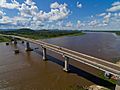
Paraguay River in Mato Grosso do Sul
-
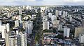
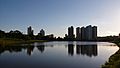
Aerial view of Campo Grande, the capital.
-
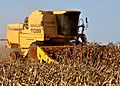
Corn in Dourados
-
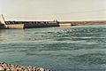
Engineer Souza Dias Dam.
-
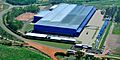
Metalfrio headquarters in Três Lagoas
-
Campo Grande is the most important educational centre of the state.
-
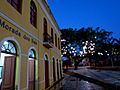
ENFOB Museum in Campo Grande.
-
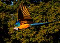
Blue-and-yellow macaw in Bonito
-
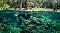
Recreational scuba diver in Bonito.
-
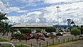
Campo Grande International Airport.
-
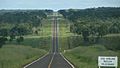
MS-040 in Mato Grosso do Sul.


4set2009.jpg)


.jpg)
See also
 In Spanish: Mato Grosso del Sur para niños
