
Sergipe facts for kids
Quick facts for kids
State of Sergipe
|
|||
|---|---|---|---|
|
|||

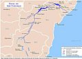
Location of State of Sergipe in Brazil
|
|||
| Country | |||
| Capital and Largest City | Aracaju | ||
| Area | |||
| • Total | 21,910.348 km2 (8,459.633 sq mi) | ||
| Area rank | 26th | ||
| Population
(2012)
|
|||
| • Total | 2,110,867 | ||
| • Rank | 22nd | ||
| • Density | 96.341099/km2 (249.52230/sq mi) | ||
| • Density rank | 5th | ||
| Demonym(s) | Sergipano | ||
| GDP | |||
| • Year | 2006 estimate | ||
| • Total | R$ 15,126,000,000 (21st) | ||
| • Per capita | R$ 7,560 (16th) | ||
| HDI | |||
| • Year | 2005 | ||
| • Category | 0.742 – medium (20th) | ||
| Time zone | UTC-3 (BRT) | ||
| • Summer (DST) | UTC-2 (BRST) | ||
| Postal Code |
49000-000 to 49990-000
|
||
| ISO 3166 code | BR-SE | ||
| Website | se.gov.br | ||


Sergipe is the smallest state in Brazil, but it's full of interesting places and history! Its capital and largest city is Aracaju. Sergipe shares its borders with two other Brazilian states: Bahia to the south and west, and Alagoas to the north.
Contents
Exploring Sergipe's Geography
Sergipe has a diverse landscape. Most of its land is covered by a unique type of dry forest called caatinga. This area is known for its tough, drought-resistant plants.
Along the Atlantic coast, you'll find a strip of lush rainforest. Near the coast, there are also areas with swamps. These different environments make Sergipe a home for many kinds of plants and animals.
Sergipe's Economy
The economy of Sergipe mainly relies on farming and some industry.
- Sugarcane: The most important crop grown in Sergipe is sugarcane. It's used to make sugar and ethanol.
- Cassava: Another important crop is cassava, also known as manioc. This root vegetable is a staple food in many parts of Brazil.
- Petroleum: Sergipe also has a small petroleum industry, which involves finding and processing oil.
A Look at Sergipe's History
The history of Sergipe is rich and goes back many centuries.
- First Inhabitants: The first people to live in the area that is now Sergipe were from the Tupi Tribe. They were the original inhabitants of this land.
- Meaning of the Name: The name "Sergipe" actually comes from the Tupi language. It means "river of crabs" or "crab river," which tells us a bit about the local wildlife.
- Portuguese Arrival: Later, people from Portugal arrived and took control of the area. They established a settlement called São Cristóvão.
- French Invasion: For a short time, French pirates invaded Sergipe. However, they didn't stay long and eventually left.
- Part of Brazil: Today, Sergipe is a proud and free state within the country of Brazil.
| States of Brazil | |
|---|---|
| Acre | Alagoas | Amapá | Amazonas | Bahia | Ceará | Espírito Santo | Goiás | Maranhão | Mato Grosso | Mato Grosso do Sul | Minas Gerais | Pará | Paraíba | Paraná | Pernambuco | Piauí | Rio de Janeiro | Rio Grande do Norte | Rio Grande do Sul | Rondônia | Roraima | Santa Catarina | São Paulo | Sergipe | Tocantins | |
| Federal District: Brazilian Federal District | |
Images for kids
-

Aerial tramway in Aracaju.
-
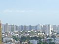
Skyline of Aracaju.
-
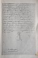
Royal decree of King John VI, granting the administrative emancipation of the Captaincy of Sergipe on July 8, 1820.
-
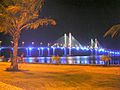
Aracaju-Barra Bridge at night.
-
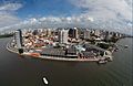
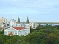
Aracaju is the largest city of the state.
-
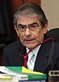
Carlos Ayres Britto, President of Brazil's Supreme Court.
-
Aracaju is the most important educational centre of the state.
-
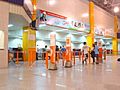
International Airport of Aracaju.
-
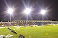
Batistão stadium in Aracaju.
-
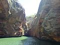
Xingó Canyon.
-
São Francisco river.


See also
 In Spanish: Sergipe para niños
