
Human settlement facts for kids
.JPG)
A settlement is a place where people live, either for a short time or permanently. It's a general word used in subjects like archaeology, geography, and history. Settlements can be small places like hamlets or large ones like cities. People who are nomadic (meaning they move around a lot) do not usually create permanent settlements. Sometimes, when people come from far away to live in a new place, it's called a colony.
Contents
History of Human Settlements
The earliest signs of human settlements were found at Jebel Irhoud. Here, remains of early modern humans dating back about 300,000 years ago were discovered.
The oldest known built homes are huts made of mud and branches. These were found near the Sea of Galilee and are about 17,000 years old. Later, around 10,000 BC, the Natufian people built houses in the Levant area. After people learned about agriculture, remains of villages and other settlements became much more common. This is because farming allowed people to stay in one place and grow their food.
How Settlements Look in History

Landscape history looks at how settlements are shaped. For example, it studies if homes are spread out (called dispersed) or grouped closely together (called nucleated). Studying the shape of cities is a part of this.
Settlements can be put in order by their size or importance. This is called a settlement hierarchy. It helps classify settlements around the world. What one country calls a 'town' might be called a 'village' in another.
How Countries Count Settlements
Different countries have their own ways of defining and counting settlements. For example, Geoscience Australia says a populated place has 200 or more people. In Croatia, they use the term naselja for settlements. The United States Geological Survey (USGS) defines populated places as areas with buildings and a permanent population, like a city or village. These places usually don't have official legal boundaries.
Mapping Settlements with Technology
In geospatial predictive modeling, settlements are seen as a group of buildings where people live and work, like a city, town, or village.
The Global Human Settlement Layer (GHSL) is a project that creates maps showing where humans have lived on Earth over time. It uses satellite images, census data, and other information. This helps us understand how human presence and buildings have changed across the planet. The GHSL project shares its data and methods freely.
When Settlements are Left Behind

Sometimes, settlements are left empty. These are called "abandoned populated places" or ghost towns. The buildings might still be there and easy to visit, often becoming tourist spots.
A town might become a ghost town if the main reason people lived there, like a mine or factory, closes down. It can also happen if a government project, like building a dam, floods the town. Natural disasters, wars, or even too much crime can also cause people to leave a settlement. Sometimes, a place is called a ghost town even if a few people still live there, but far fewer than before.
Images for kids
-
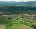
The small town of Flora, Oregon in the United States is unincorporated, but is considered a populated place.
-
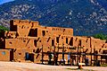
Taos Pueblo, an ancient pueblo belonging to a Taos-speaking Native American tribe of Pueblo people. It is approximately 1000 years old and lies about 1 mile (1.6 km) north of the modern city of Taos, New Mexico.


See also
 In Spanish: Asentamiento para niños
