Pirkanmaa facts for kids
Quick facts for kids
Pirkanmaa
Pirkanmaan maakunta
landskapet Birkaland |
|||
|---|---|---|---|
|
|||

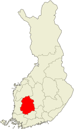
Pirkanmaa on a map of Finland
|
|||
| Country | Finland | ||
| Historical province | Satakunta, Tavastia | ||
| Capital | Tampere | ||
| Area | |||
| • Total | 14,469.39 km2 (5,586.66 sq mi) | ||
| Population
(2013)
|
|||
| • Total | 500,166 | ||
| • Density | 34.56718/km2 (89.52858/sq mi) | ||
| Time zone | UTC+2 (EET) | ||
| • Summer (DST) | UTC+3 (EEST) | ||
| ISO 3166 code | FI-11 | ||
| NUTS | 192 | ||
| Regional bird | White wagtail (Motacilla alba) | ||
| Regional fish | Asp (Aspius aspius) | ||
| Regional flower | Bird cherry (Prunus padus) | ||
| Website | pirkanmaa.fi | ||
Pirkanmaa is a cool region located in western Finland. It's a place where many people live and work. As of 2013, about 500,000 people called Pirkanmaa home. The region is known for its beautiful nature and lively cities.
Pirkanmaa is surrounded by several other regions. Its neighbors include Southwest Finland and Satakunta to the west. To the south, you'll find Kanta-Häme and Päijänne Tavastia. To the north, it borders Southern Ostrobothnia and Central Finland.
Contents
Discover Pirkanmaa: A Region in Finland
Pirkanmaa is one of the 19 regions in Finland. These regions help organize the country. They manage things like healthcare and local development. Pirkanmaa is a very important part of Finland.
The Capital City: Tampere
The biggest and most important city in Pirkanmaa is Tampere. It's the capital of the region. Tampere is a busy city with lots of things to do. It's famous for its industrial history and beautiful lakes.
Nature and Wildlife in Pirkanmaa
Pirkanmaa has a rich natural environment. The region has chosen special symbols to represent its nature. These symbols show the unique plants and animals found here.
Regional Symbols: Bird, Fish, and Flower
The official regional bird of Pirkanmaa is the White wagtail. This small bird is known for its long tail. It often wags its tail up and down. You can spot them in many open areas.
The regional fish is the Asp. This is a type of freshwater fish. It lives in rivers and lakes. The asp is a strong swimmer and a popular fish for anglers.
For its regional flower, Pirkanmaa chose the Bird cherry. This tree has beautiful white flowers. They bloom in the spring. The flowers smell very sweet.
Cities and Towns of Pirkanmaa
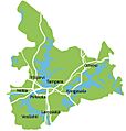
Pirkanmaa is made up of many different cities and towns. These are called municipalities. Each municipality has its own local government. They work together to make Pirkanmaa a great place to live.
Here is a list of the municipalities in Pirkanmaa:
- Akaa
- Hämeenkyrö
- Ikaalinen
- Juupajoki
- Kangasala
- Kihniö
- Lempäälä
- Vilppula
- Nokia
- Orivesi
- Parkano
- Pirkkala
- Punkalaidun
- Pälkäne
- Ruovesi
- Sastamala
- Tampere
- Urjala
- Valkeakoski
- Vesilahti
- Virrat
- Ylöjärvi
Images for kids
-
Tampere, the capital city of the Pirkanmaa region
See also
 In Spanish: Región de Pirkanmaa para niños
 | Laphonza Butler |
 | Daisy Bates |
 | Elizabeth Piper Ensley |


