
Satakunta facts for kids
Quick facts for kids
Satakunta
Satakunnan maakunta
landskapet Satakunta |
|||
|---|---|---|---|
|
|||

Satakunta on a map of Finland
|
|||
| Country | Finland | ||
| Historical province | Satakunta | ||
| Capital | Pori | ||
| Area | |||
| • Total | 8,412.47 km2 (3,248.07 sq mi) | ||
| Population
(2013)
|
|||
| • Total | 224,556 | ||
| • Density | 26.69323/km2 (69.13515/sq mi) | ||
| ISO 3166 code | FI-17 | ||
| NUTS | 196 | ||
| Regional animal | Eurasian beaver | ||
| Regional bird | Eurasian blue tit | ||
| Regional fish | European river lamprey | ||
| Regional flower | Common Sea-buckthorn | ||
| Regional lake | Pyhäjärvi | ||
| Regional mineral | Sandstone | ||
| Website | satakunta.fi | ||

Satakunta is a region located in western Finland. Think of a region as a special area within a country. As of November 2013, about 225,000 people lived there.
Satakunta shares its borders with several other regions. These include Southwest Finland, Pirkanmaa, Southern Ostrobothnia, and Ostrobothnia.
Images for kids
-
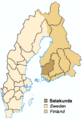
Map of the historical province of Satakunta
-
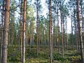
A young group of pine trees in Northern Satakunta.
-
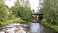
The Eura River flowing through Panelia, a village in Eura.
-
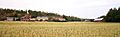
The village of Sorkka in Rauma shows the typical flat countryside of Satakunta's coast.


.jpg)
See also
 In Spanish: Región de Satakunta para niños

All content from Kiddle encyclopedia articles (including the article images and facts) can be freely used under Attribution-ShareAlike license, unless stated otherwise. Cite this article:
Satakunta Facts for Kids. Kiddle Encyclopedia.