
Rio Grande do Norte facts for kids
Quick facts for kids
State of Rio Grande do Norte
|
|||
|---|---|---|---|
|
|||

Location of State of Rio Grande do Norte in Brazil
|
|||
| Country | |||
| Capital and Largest City | Natal | ||
| Area | |||
| • Total | 52,796.791 km2 (20,384.955 sq mi) | ||
| Area rank | 22nd | ||
| Population
(2012)
|
|||
| • Total | 3,228,198 | ||
| • Rank | 16th | ||
| • Density | 61.143830/km2 (158.361792/sq mi) | ||
| • Density rank | 10th | ||
| Demonym(s) | Potiguar or Norte-rio-grandense | ||
| GDP | |||
| • Year | 2006 estimate | ||
| • Total | R$ 20,557,000,000 (18th) | ||
| • Per capita | R$ 6,754 (20th) | ||
| HDI | |||
| • Year | 2005 | ||
| • Category | 0.738 – medium (21st) | ||
| Time zone | UTC-3 (BRT) | ||
| • Summer (DST) | UTC-2 (BRST) | ||
| Postal Code |
59000-000 to 59990-000
|
||
| ISO 3166 code | BR-RN | ||
| Website | rn.gov.br | ||


Rio Grande do Norte is one of Brazil's 26 states. It is located in the northeastern part of the country. This state sits right on the edge of the South American continent.
Contents
Exploring Rio Grande do Norte's Geography
Rio Grande do Norte has a very long coastline. The state is famous for its beautiful beaches. It also has many large sand dunes. The air here is known to be the cleanest in all of South America.
Climate and Weather Patterns
Rio Grande do Norte has two main climates. This is because of a large mountain chain called Serra da Borborema. The area along most of the coast is very tropical. This means it is warm and humid.
However, much of the state's inland area is very dry. This dry climate is not just from low rainfall. It often goes years with very little or no rain at all. Most of the state's interior is part of the Polygon of Droughts. This area gets special help from the federal government.
Unique Islands and Atolls
Rocas Atoll is a special part of Rio Grande do Norte. It is an island in the Atlantic Ocean. This atoll is about 260 kilometers (160 miles) northeast of Natal.
A Look at Rio Grande do Norte's History
The first European to reach this region might have been Alonso de Ojeda from Spain in 1499. The very tip of northeastern South America, called Cape São Roque, was first seen by European navigators in 1501. This happened during a Portuguese expedition led by Amerigo Vespucci. He named the spot after the saint of that day.
Naming the "Great River"
The Vespucci expedition also named the Potengi river "Rio Grande." This name is Portuguese for "Great River." The entire area and later the state were named after this river. For many decades, no permanent European settlement was built here.
Early Settlements and Conflicts
In the 16th century (between 1535 and 1598), French pirates explored the area. In 1598, the Portuguese built a fort called Forte dos Reis Magos. The next year, they founded the city of Natal.
In 1633, the Portuguese and the Dutch fought over the area. The Dutch were finally forced out in 1654.
Rio Grande do Norte's Role in World War II
During World War II, Rio Grande do Norte became an important Allied airbase. This base was used to launch attacks against German-occupied North Africa.
Brazil's Space Exploration Hub
In 1964, Latin America's first space launch site was built in Rio Grande do Norte. It is called Barreira do Inferno (which means "Hell's Barrier"). People often call it the "Brazilian NASA" because of its importance in space research.
Understanding Rio Grande do Norte's Economy
Historically, the economy of Rio Grande do Norte was based on sugar and cattle farming. In the 1980s, the state government realized that tourism could be a very good industry.
Growth of Tourism and Investment
Since then, more money has been used to build places for tourists. They also repair old colonial buildings in major cities. This helps attract visitors from all over the world.
Agricultural Products and Famous Trees
Fruit is also a big part of the economy in Rio Grande do Norte. The state grows 70% of all the melons in Brazil. The state is also known for its large mango and cashew fields.
The world's largest cashew tree is located here. It has a circumference of 500 meters (about 1,640 feet). It covers an area of 7,300 square meters (about 78,576 square feet). This amazing tree is 70 times bigger than an average cashew tree!
Major Cities in Rio Grande do Norte
Natal is the capital and the largest city in the state. Other important cities include:
- Açu
- Angicos
- Apodi
- Ceará-Mirim
- Currais Novos
- Parnamirim
- Japi
- Mossoró
- Caicó
- São Fernando
The Flag of Rio Grande do Norte
The flag of Rio Grande do Norte was officially adopted on December 3, 1957. Its design was created by Luis de Camara Cascudo.
Symbols on the State Flag
In the middle of the flag is the coat of arms of the state. This coat of arms was adopted earlier, on July 1, 1909. It shows a sailing boat on the coast in the center. This represents the important fishing and salt industries of the state.
Above the boat is a bar with two flowers on the sides. In the center of this bar are two cotton bolls. On the sides of the shield are a coconut palm on the right and a carnauba palm on the left. These two palms are connected by two branches of sugar cane. The star above the shield represents Rio Grande do Norte as one of the states that make up Brazil.
| States of Brazil | |
|---|---|
| Acre | Alagoas | Amapá | Amazonas | Bahia | Ceará | Espírito Santo | Goiás | Maranhão | Mato Grosso | Mato Grosso do Sul | Minas Gerais | Pará | Paraíba | Paraná | Pernambuco | Piauí | Rio de Janeiro | Rio Grande do Norte | Rio Grande do Sul | Rondônia | Roraima | Santa Catarina | São Paulo | Sergipe | Tocantins | |
| Federal District: Brazilian Federal District | |
Images for kids
-
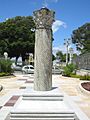
Column Capitolina was donated to the state by Mussolini.
-
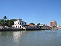
Rampa, one of the American air bases used during World War II.
-
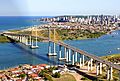
Natal, the capital of the state.
-
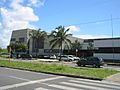
Federal University of Rio Grande do Norte in Natal, considered one of the best in the country.
-
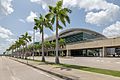
Greater Natal International Airport.
-
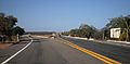
BR-304 highway.
-
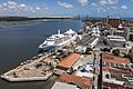
Entrance of the Port of Natal
-
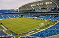
Arena das Dunas in Natal.


_-_panoramio.jpg)
See also
 In Spanish: Río Grande del Norte para niños
