
Amapá facts for kids
Quick facts for kids
Amapá
|
|||
|---|---|---|---|
|
|||

Location of State of Amapá in Brazil
|
|||
| Country | |||
| Capital and largest city | Macapá | ||
| Area | |||
| • Total | 142,814.585 km2 (55,141.020 sq mi) | ||
| Area rank | 18th | ||
| Population
(2014)
|
|||
| • Total | 750,912 | ||
| • Rank | 26th | ||
| • Density | 5.257950/km2 (13.618029/sq mi) | ||
| • Density rank | 23rd | ||
| Demonym(s) | Amapaense | ||
| GDP | |||
| • Year | 2012 | ||
| • Total | R$ 10,420,000,000 (25th) | ||
| • Per capita | R$ 14,915.00 (15th) | ||
| HDI | |||
| • Year | 2014 | ||
| • Category | 0.747 - high (12th) | ||
| Time zone | UTC-3 (BRT) | ||
| Postal Code |
68900-000 to 68999-000
|
||
| ISO 3166 code | BR-AP | ||
| Website | ap.gov.br | ||


Amapá is a state in the northern part of Brazil. It is located in the far north of the country. To the north, Amapá shares a border with French Guiana. The Atlantic Ocean is to its east. To the south and west, it borders the Brazilian state of Pará.
Amapá is mostly covered by thick rainforest. This state is also known for producing important natural resources. These include iron and other valuable metals.
Amapá became an official Brazilian state in 1988.
| States of Brazil | |
|---|---|
| Acre | Alagoas | Amapá | Amazonas | Bahia | Ceará | Espírito Santo | Goiás | Maranhão | Mato Grosso | Mato Grosso do Sul | Minas Gerais | Pará | Paraíba | Paraná | Pernambuco | Piauí | Rio de Janeiro | Rio Grande do Norte | Rio Grande do Sul | Rondônia | Roraima | Santa Catarina | São Paulo | Sergipe | Tocantins | |
| Federal District: Brazilian Federal District | |
Images for kids
-
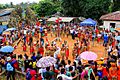
Celebration of Indian Day in Manga
-
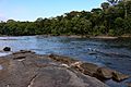
Amapá National Forest
-
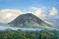
Karupina mountain in the Uaçá Indigenous Territory, Amapá, Brazil.


.jpg)

See also
 In Spanish: Amapá para niños

All content from Kiddle encyclopedia articles (including the article images and facts) can be freely used under Attribution-ShareAlike license, unless stated otherwise. Cite this article:
Amapá Facts for Kids. Kiddle Encyclopedia.