
Tocantins (state) facts for kids
Quick facts for kids
State of Tocantins
|
|||
|---|---|---|---|
|
|||

Location of State of Tocantins in Brazil
|
|||
| Country | |||
| Capital and Largest City | Palmas | ||
| Area | |||
| • Total | 277,620.91 km2 (107,190.03 sq mi) | ||
| Area rank | 10th | ||
| Population
(2010 census)
|
|||
| • Total | 1,383,453 | ||
| • Rank | 24th | ||
| • Density | 4.9832450/km2 (12.906545/sq mi) | ||
| • Density rank | 22nd | ||
| Demonym(s) | Tocantinense | ||
| GDP | |||
| • Year | 2006 estimate | ||
| • Total | R$ 9,607,000,000 (24th) | ||
| • Per capita | R$ 7,210 (17th) | ||
| HDI | |||
| • Year | 2005 | ||
| • Category | 0.756 – medium (15th) | ||
| Time zone | UTC-3 (BRT) | ||
| • Summer (DST) | UTC-2 (BRST) | ||
| Postal Code |
77000-000 to 77990-000
|
||
| ISO 3166 code | BR-TO | ||
| Website | to.gov.br | ||


Tocantins is a state located in central Brazil. It was created in 1988 from the northern part of the state of Goiás. The capital city, Palmas, began to be built in 1989. Palmas is a very new city compared to many other cities in the region.
Contents
What is Tocantins?
Tocantins is a state in the middle of Brazil. It is known for being a place where two different types of land meet. These are the Amazon Rainforest and Brazil's grassy flatlands. This mix of environments makes Tocantins a special place.
How Was Tocantins Formed?
Tocantins was officially made a state in 1988. Before that, it was part of the state of Goiás. Creating a new state helped the northern part of Goiás get more attention and development.
What is the Capital City of Tocantins?
The capital of Tocantins is Palmas. It is a very modern city because it was planned and built starting in 1989. This makes Palmas one of Brazil's newest capital cities.
What is the Economy of Tocantins Like?
The state of Tocantins is very important for farming and raising animals.
Raising Animals
One of the main activities in Tocantins is raising cows and other farm animals. This is a big part of the state's economy.
Farming and Agriculture
The land in Tocantins is also used for growing crops. For example, Formoso do Araguaia is known for its irrigated rice farms. This means they use special systems to water the rice fields.
How Do People Travel in Tocantins?
Roads are very important for getting around Tocantins.
Main Highways
The BR-153 highway is a major road in the state. It is also called the Belém-Brasília Highway. This road helps connect Tocantins to other parts of Brazil.
| States of Brazil | |
|---|---|
| Acre | Alagoas | Amapá | Amazonas | Bahia | Ceará | Espírito Santo | Goiás | Maranhão | Mato Grosso | Mato Grosso do Sul | Minas Gerais | Pará | Paraíba | Paraná | Pernambuco | Piauí | Rio de Janeiro | Rio Grande do Norte | Rio Grande do Sul | Rondônia | Roraima | Santa Catarina | São Paulo | Sergipe | Tocantins | |
| Federal District: Brazilian Federal District | |
Images for kids
-
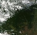
The vast Amazon rainforest.
-
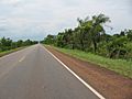
The BR-153 highway, a key route in Tocantins.
-
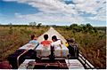
The beautiful landscape of Jalapão in Tocantins.
-
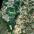
An irrigated rice plantation in Formoso do Araguaia.


See also
 In Spanish: Tocantins para niños
