Corumbá facts for kids
Quick facts for kids
Corumbá
|
|||
|---|---|---|---|
|
Municipality
|
|||
| Municipality of Corumbá | |||
|
|
|||
|
|||
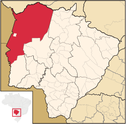
Location in Mato Grosso do Sul
|
|||
| Country | |||
| Region | Center-West | ||
| State | |||
| Founded | 1778 | ||
| Area | |||
| • Total | 64,960 km2 (25,080 sq mi) | ||
| Elevation | 118 m (387 ft) | ||
| Population
(2020 est.)
|
|||
| • Total | 112,058 | ||
| • Density | 1.72503/km2 (4.4678/sq mi) | ||
| Time zone | UTC−4 (AMT) | ||
| HDI (2010) | 0.700 – high | ||
Corumbá is a city in the Brazilian state of Mato Grosso do Sul. It is located about 425 kilometers (264 miles) northwest of Campo Grande, the state's capital city. Around 112,000 people live in Corumbá.
The city's economy relies on agriculture (farming), animal husbandry (raising animals), mineral extraction (mining), and tourism. Corumbá is known as the main entry point to the Pantanal, which is the world's largest wetland area.
Because Corumbá is very close to Bolivia, many Bolivian people live there. They form a special cultural community within the city. Corumbá also has its own airport, Corumbá International Airport.
Corumbá is the westernmost and northernmost city in Mato Grosso do Sul. It is also the largest city in the state by land area, covering 18% of its territory. It is the eleventh largest city in all of Brazil by area. Inside Corumbá's territory, there is another small city called Ladário.
Contents
History of Corumbá
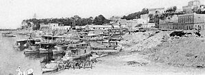
Corumbá was first set up as a military base and colony in 1778 by the Spanish. It became very important after the Paraguayan War (1865–1870). This was when the Paraguay River was opened for international trade.
Near Corumbá, there are hills called Mt Urucum. These hills have huge amounts of valuable minerals. In 1878, Corumbá officially became a city.
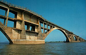
In 1938, the governments of Brazil and Bolivia decided to build a railway. This railway, called the Santa Cruz-Corumbá Railway, connected Santa Cruz de la Sierra in Bolivia with the Brazilian state of Mato Grosso. The railway was completed in 1955.
Exploring the Pantanal
The Pantanal is the most important wetland plain in all of South America. A large part of this amazing area is in Mato Grosso do Sul, and Corumbá is often called its "entrance door." The Pantanal in Mato Grosso do Sul is famous for being one of the most beautiful and diverse natural places on Earth.
One of the biggest attractions of the Pantanal is its incredible variety of animals. You can find caimans, anacondas, many kinds of fish, capybaras, tapirs, bright blue hyacinth macaws, graceful herons, and tall jabiru storks.
The Pantanal is so special that it was recognized as a National Heritage site in Brazil's Constitution in 1988. It is also a UNESCO World Heritage site and a Biosphere Reserve.
According to the World Wide Fund for Nature (1999), the Pantanal is home to:
- 650 types of birds
- 80 types of mammals
- 260 types of fish
- 50 types of reptiles
It is a very important place for protecting different kinds of life. It is considered one of the biggest breeding grounds for animals in America. More than 263 types of fish, 122 types of mammals, 93 types of reptiles, 1,132 types of butterflies, 656 types of birds, and 1,700 types of plants have been found and listed there.
Corumbá's Borders with Bolivia
The city of Corumbá shares borders with both Bolivia and Paraguay. This is called a triple border situation. Corumbá's city area is right next to the Bolivian cities of Puerto Suárez and Puerto Quijarro. These Bolivian cities have a "Free Zone" where people can buy imported goods and Bolivian crafts.
The border with Paraguay is located at the very southern end of Corumbá's farming area. In 2014, Bolivian visitors needed to show they had at least $800 to get a temporary visa to enter Brazil.
Because of its location, Corumbá has one of the largest populations of people who are Bolivian-Brazilians.
City Life and Population
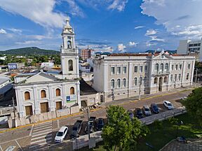
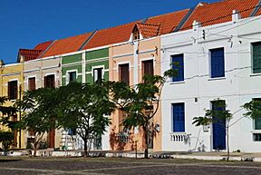
Corumbá is made up of two main parts. The lower area is the older part of the city, with interesting old buildings, located near the port. The upper area is newer and much larger. It is laid out in a grid pattern, like a chessboard.
The buildings in Corumbá are different from many other old Brazilian cities. Instead of the old Portuguese colonial style, Corumbá's buildings often show an Italian neoclassical style. This is similar to buildings you might see in central Asunción (Paraguay), old parts of Buenos Aires (Argentina), or towns in Uruguay.
Most of Corumbá's population lives in urban areas, with about 90% living in the city. In recent years, people in Corumbá are living longer, and fewer babies are being born. This means the population is getting older.
Here's how Corumbá's population has grown over the years:
| Population growth | |
|---|---|
| 1970 | 48,600 |
| 1980 | 67,500 |
| 1991 | 88,360 |
| 1993 | 89,585 |
| 1996 | 89,083 |
| 2000 | 95,700 |
| 2004 | 99,441 |
| 2005 | 100,268 |
| 2006 | 101,089 |
| 2010 | 103,772 |
| 2013 | 107,347 |
| 2018 | 110,806 |
Based on the 2010 census, here's a look at the different groups of people living in Corumbá:
| Color/Race | Number | Percentage |
|---|---|---|
| Mixed | 65,685 | 63.34% |
| White | 29,000 | 27.96% |
| Black | 7,367 | 7.10% |
| Asian | 1,252 | 1.21% |
| Indigenous | 398 | 0.38% |
Sister Cities
Corumbá has special connections with other cities around the world, called "sister cities":
Climate
| Climate data for Corumbá (1981–2010) | |||||||||||||
|---|---|---|---|---|---|---|---|---|---|---|---|---|---|
| Month | Jan | Feb | Mar | Apr | May | Jun | Jul | Aug | Sep | Oct | Nov | Dec | Year |
| Mean daily maximum °C (°F) | 33.7 (92.7) |
33.3 (91.9) |
33.0 (91.4) |
31.8 (89.2) |
28.9 (84.0) |
28.0 (82.4) |
28.6 (83.5) |
30.5 (86.9) |
32.3 (90.1) |
34.1 (93.4) |
34.0 (93.2) |
34.2 (93.6) |
31.9 (89.4) |
| Daily mean °C (°F) | 27.9 (82.2) |
27.5 (81.5) |
27.2 (81.0) |
25.9 (78.6) |
23.3 (73.9) |
22.1 (71.8) |
22.0 (71.6) |
23.8 (74.8) |
25.6 (78.1) |
27.5 (81.5) |
27.7 (81.9) |
27.9 (82.2) |
25.7 (78.3) |
| Mean daily minimum °C (°F) | 23.8 (74.8) |
23.7 (74.7) |
23.6 (74.5) |
21.8 (71.2) |
19.2 (66.6) |
17.9 (64.2) |
17.5 (63.5) |
18.8 (65.8) |
20.6 (69.1) |
22.8 (73.0) |
23.1 (73.6) |
23.4 (74.1) |
21.4 (70.5) |
| Average precipitation mm (inches) | 155.3 (6.11) |
134.3 (5.29) |
126.5 (4.98) |
65.7 (2.59) |
50.3 (1.98) |
17.3 (0.68) |
23.1 (0.91) |
26.9 (1.06) |
40.4 (1.59) |
86.2 (3.39) |
117.5 (4.63) |
154.5 (6.08) |
998.0 (39.29) |
| Average precipitation days (≥ 1.0 mm) | 12 | 10 | 10 | 6 | 4 | 2 | 2 | 2 | 4 | 7 | 8 | 10 | 77 |
| Mean monthly sunshine hours | 210.4 | 185.3 | 203.9 | 220.4 | 212.7 | 204.2 | 235.6 | 201.0 | 187.5 | 217.5 | 216.0 | 234.1 | 2,528.6 |
| Source: Instituto Nacional de Meteorologia | |||||||||||||
| Climate data for Nhecolândia (Nhumirim) (1981–2010) | |||||||||||||
|---|---|---|---|---|---|---|---|---|---|---|---|---|---|
| Month | Jan | Feb | Mar | Apr | May | Jun | Jul | Aug | Sep | Oct | Nov | Dec | Year |
| Mean daily maximum °C (°F) | 33.3 (91.9) |
33.0 (91.4) |
33.3 (91.9) |
32.4 (90.3) |
29.7 (85.5) |
29.1 (84.4) |
29.8 (85.6) |
32.3 (90.1) |
33.1 (91.6) |
34.2 (93.6) |
34.1 (93.4) |
33.6 (92.5) |
32.3 (90.1) |
| Daily mean °C (°F) | 27.6 (81.7) |
27.5 (81.5) |
27.2 (81.0) |
25.5 (77.9) |
22.3 (72.1) |
21.2 (70.2) |
20.8 (69.4) |
22.6 (72.7) |
24.7 (76.5) |
27.0 (80.6) |
27.3 (81.1) |
27.6 (81.7) |
25.1 (77.2) |
| Mean daily minimum °C (°F) | 23.4 (74.1) |
23.4 (74.1) |
22.8 (73.0) |
20.6 (69.1) |
16.8 (62.2) |
15.5 (59.9) |
14.2 (57.6) |
15.4 (59.7) |
18.3 (64.9) |
21.5 (70.7) |
21.8 (71.2) |
22.8 (73.0) |
19.7 (67.5) |
| Average precipitation mm (inches) | 172.8 (6.80) |
142.1 (5.59) |
128.9 (5.07) |
68.2 (2.69) |
55.8 (2.20) |
17.2 (0.68) |
10.2 (0.40) |
17.5 (0.69) |
33.8 (1.33) |
100.7 (3.96) |
135.9 (5.35) |
163.1 (6.42) |
1,046.2 (41.19) |
| Average precipitation days (≥ 1.0 mm) | 11 | 10 | 9 | 5 | 4 | 2 | 2 | 2 | 2 | 6 | 8 | 9 | 70 |
| Average relative humidity (%) | 82.4 | 83.7 | 84.8 | 82.3 | 81.9 | 81.5 | 76.6 | 70.7 | 69.0 | 73.5 | 75.7 | 79.4 | 78.5 |
| Mean monthly sunshine hours | 189.2 | 177.4 | 210.0 | 225.9 | 211.4 | 212.2 | 230.6 | 222.0 | 177.7 | 201.1 | 213.8 | 206.6 | 2,477.9 |
| Source: Instituto Nacional de Meteorologia | |||||||||||||
See also
 In Spanish: Corumbá para niños
 | Victor J. Glover |
 | Yvonne Cagle |
 | Jeanette Epps |
 | Bernard A. Harris Jr. |


