
Pico da Neblina facts for kids
Quick facts for kids Pico da Neblina |
|
|---|---|
.jpg)
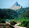
Pico da Neblina in 2015, with the usual clouds.
|
|
| Highest point | |
| Elevation | 2,995.30 m (9,827.1 ft) |
| Prominence | 2,887 m (9,472 ft) Ranked 112th |
| Listing | Country high point Ultra |
| Geography | |

Pico da Neblina
Location in Brazil
|
|
| Location | State of Amazonas, Brazil |
| Parent range | Serra da Neblina ("Mountain Range of the Mists"), a section of Serra do Imeri in the Guiana Highlands |
| Climbing | |
| First ascent | 1965 |
| Easiest route | From the town of São Gabriel da Cachoeira to Iazinho river by truck, then by boat on Iazinho river, Ia river, Caburaí river and Tucano river, then on a jungle trail with three camps (Tucano, Bebedouro Novo, Garimpo do Tucano) before the final ascent. |
Pico da Neblina is the tallest mountain in Brazil. Its name means "Mist Peak" because it's almost always covered in thick clouds. This amazing peak stands 2,995.3 metres (9,827 ft) above sea level.
It is part of the Serra da Neblina mountain range. This range is found in the Guiana Highlands, right on the border between Brazil and Venezuela. A survey in 1962 showed that the very top of Pico da Neblina is just inside Brazil. It's only about 687 m (2,254 ft) from the Venezuelan border.
Many people think this mountain is the highest in South America outside the Andes mountains. But that's not quite right! The Sierra Nevada de Santa Marta in Colombia is actually taller. Pico da Neblina was first climbed in 1965 by a team from the Brazilian Army.
Contents
Where is Pico da Neblina Located?
Pico da Neblina is officially in the town area of Santa Isabel do Rio Negro. This town is in the state of Amazonas. However, the mountain is quite far from the town itself. It's about 180 km (112 mi) away.
The closest city is São Gabriel da Cachoeira. It's about 140 km (87 mi) in a straight line. Most climbing trips start from this city. The mountain is inside the Pico da Neblina National Park in Brazil. Its northern parts are also protected in Venezuela's Serranía de la Neblina National Park.
These two parks, along with another park in Venezuela, create a huge protected area. It's about 80,000 square kilometers. This might be the biggest national park system in tropical rainforests anywhere! Pico da Neblina is also located in the land of the Yanomami people.
Understanding Common Misconceptions
Many people believe Pico da Neblina is exactly on the border between Brazil and Venezuela. While the whole mountain area (called a massif) is on the border, the main summit is entirely in Brazil. It's 687 m (2,254 ft) away from the actual border line.
Another common mistake is thinking it's the highest point in South America outside the Andes. This is incorrect. The Sierra Nevada de Santa Marta in Colombia is much taller. It's also completely separate from the Andes. However, Pico da Neblina is the highest point east of the Andes. This means it's the tallest peak in a very large part of the continent.
Its neighbor, Pico 31 de Março, is right on the international border. It is also the highest point in Venezuela outside of the Andes.
How Tall is Pico da Neblina?
For many years, people thought Pico da Neblina was 3,014 metres (9,888 ft) tall. This measurement was made in 1965 using a special tool called a theodolite. A theodolite helps measure angles and distances.
But in 2004, a new and more accurate measurement was taken. A team from the Brazilian Army used modern GPS equipment. This new measurement showed the height was 2,993.78 m (9,822 ft). The official Brazilian government agency for geography, IBGE, confirmed this new height.
In 2016, the official height was slightly changed again to 2,995.30 metres (9,827.1 ft). No new trip was made to the mountain for this change. Instead, scientists used the old GPS data. They used a new, more exact map of Brazil's shape (called the geoid). This helped them calculate the height even more precisely.
What is the Mountain Like?
Pico da Neblina is made of sandstone rocks on top of older, harder rocks. The peak looks like a sharp rock pyramid or a giant tooth. It rises very high above the flat lands nearby in Brazil. The mountain range quickly goes from about 100 meters above sea level to 2,000 meters at the base of the peak. From there, the peak shoots up sharply.
The Venezuelan side of the mountain is more hilly. The climb from the plains there is not as steep. But there are still deep valleys and high rock walls. The nearby Pico 31 de Março is like a smaller peak next to Pico da Neblina. It has a smoother, rounder shape. Sometimes it's hard to tell them apart in photos.
Because Pico da Neblina is near the equator, it doesn't get extremely cold at the top. Freezing temperatures and snow are very rare. The average temperature might be around 20 °C (68 °F) during the day and 6 °C (43 °F) at night.
How Was it Discovered?
Not much is known about how Pico da Neblina was first discovered. Brazilians only found the mountain in the middle of the 20th century. This area of the Amazon region is very remote and hard to reach, even today. It was a surprise to find such a tall mountain next to the huge, low-lying Amazon Basin. Also, as its name says, Pico da Neblina is often hidden by clouds.
It's believed the mountain was first seen in the 1950s. A popular story says an airline pilot saw it during a rare moment without clouds. However, the mountain area was known on the Venezuelan side before that. There, it was called Cerro Jimé.
In 1954, a scientist named Bassett Maguire visited the area from the north. He reached a high plateau and saw the tallest peak, which didn't have a name yet. He thought it was between 8,000 and 9,000 feet tall. The whole mountain area was named Cerro de la Neblina.
Later, the highest peak was named Pico Phelps. People thought it was entirely in Venezuela. But during a Brazilian trip in 1962, it was found that the highest point was in Brazil. The Brazilians renamed it Pico da Neblina. This caused some confusion with the name Cerro de la Neblina, which is used in Venezuela for the whole mountain area. The smaller peak on the border was named Pico 31 de Março in Brazil. In Venezuela, it's now called Pico Phelps.
For many years, Brazil's highest mountain was thought to be Pico da Bandeira. This mountain is in a much more populated part of Brazil. It was only in 1965 that everyone learned Pico da Neblina was the country's highest peak. Pico da Bandeira is still the highest Brazilian mountain outside the Amazon region. It's the third highest overall, after Pico da Neblina and Pico 31 de Março.
How to Visit Pico da Neblina
Visiting Pico da Neblina is not easy. It's in a national park and a border area, which is also Yanomami land. You need a special permit from ICMBio. This is the Brazilian government group that manages national parks. You can get the permit in São Gabriel da Cachoeira.
All climbers must go with a local guide who is approved. The trek usually takes four days to get there and four days back. Three of those days are spent hiking through the rainforest. This jungle trek can be as tough as the climb itself. Getting rescued in this area is very difficult.
It's important to be careful about insect bites. Some diseases like malaria and yellow fever can be found in the area. It's a good idea to talk to a doctor who knows about tropical diseases before you go.
A Brazilian photographer named Robson Czaban climbed Pico da Neblina in 1998. He wrote that there are always some gold miners on a small plateau below the peak. This spot, called Garimpo do Tucano, is used as a base camp for the final, steepest part of the climb. Even though the miners are technically not allowed there, the Brazilian authorities often let them stay. Czaban thinks this is because they help watch the border and nature in such a remote place. He said the miners were very friendly and helpful.
Images for kids
-
Pico da Neblina in 1998 seen from the distance, without the usual clouds. The round blue-shaded secondary peak just behind it is Pico 31 de Março.

See also
 In Spanish: Pico da Neblina para niños
