
Guiana Shield facts for kids
Quick facts for kids Guiana Shield |
|
| Region | |
 |
|
| Countries | French Guiana, Suriname, Guyana, Brazil, Venezuela, Colombia |
|---|---|
| Continent | South America |
| Region | northern South America |
| Length | 2,000 km (1,243 mi), E-W |
| Width | 1,000 km (621 mi), N-S |
| Area | 2,288,000 km² (883,402 sq mi) |
| Period | Precambrian |
The Guiana Shield is a huge, ancient land area in northeastern South America. It is one of the three main parts of the South American Plate. This geological formation is about 1.7 billion years old. It forms a large part of South America's northern coast.
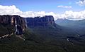
The higher parts of this region are known as the Guiana Highlands. Here, you can find flat-topped mountains called tepuis. These unique mountains look like giant tables.
The words Guiana and The Guianas are often used to talk about Guyana, Suriname, and French Guiana. Sometimes, they also include parts of Colombia, Venezuela, and Brazil that are on the Guiana Shield.
Contents
Where is the Guiana Shield?
.JPG)
The Guiana Shield stretches across six different countries. From west to east, these countries are:
- western Colombia, specifically the Guainía area.
- Venezuela, where the Orinoco river marks its northern edge.
- Guyana.
- Suriname.
- French Guiana, which is an overseas department of France.
- northern Brazil, including the states of Roraima, Pará, and Amapá. The Amazon river forms its southern border here.
The Guiana Shield is generally surrounded by the Atlantic Ocean to the east. The Orinoco river is to its north and west. The Negro river, a major branch of the Amazon, is to the southwest. And the Amazon river is to the south.
Mountains of the Guiana Shield
The Guiana Highlands are made up of many smaller plateaus and mountain ranges. The highest mountains are mostly in the western part, in Venezuela. Some of the important mountain ranges and plateaus include:
- Serra do Imeri / Cerro de la Neblina: This is the southernmost range. Pico da Neblina, the highest point in the Guiana Shield, is found here.
- Sierra / Cerro Parima: This range is between Venezuela and Brazil. The Orinoco river starts here.
- Pacaraima Mountains: This range is on the border of Venezuela, Guyana, and Brazil. Mount Roraima, a famous tepui, is located here.
- La Gran Sabana: This is a large plateau in Venezuela, part of the Canaima National Park.
- Tumuk Humak Mountains (Serra do Tumucumaque): These mountains are on the border of Suriname, Brazil, and French Guiana.
The highest point in the entire Guiana Shield is Pico da Neblina in Brazil. It stands at about 2,995 meters (9,827 feet) tall. This peak is also the highest mountain in Brazil.
Rivers and Waterfalls
Many rivers begin in the Guiana Highlands. Most of them flow north towards the Atlantic Ocean. Some of these important rivers are:
- The Orinoco river, which starts in the Sierra Parima.
- The Essequibo, the main river in Guyana. It starts in the Acarai Mountains.
- The Courantyne, the longest river in Suriname. It also starts in the Acarai Mountains.
- The Maroni river, which forms the border between French Guiana and Suriname.
- The Oyapock river, which forms most of the border between French Guiana and the Brazilian state of Amapá.
The region is also famous for its amazing waterfalls. These include the Angel Falls in Venezuela, which is about 979 meters (3,212 feet) high. Another is the Kaieteur Falls in Guyana, which is about 226 meters (741 feet) high.
Climate of the Guiana Shield
The Guiana Shield generally has a tropical climate. This means it's usually warm, with average yearly temperatures above 25°C (77°F) at sea level. Because the Guiana Shield is close to the equator, its weather mostly depends on how high up a place is and the effects of the trade winds. These trade winds blow from the east and northeast, coming from the Atlantic Ocean.
The heaviest rains typically fall between May and August. There's also a shorter, less intense rainy season from December to January, mostly along the coast. Even during most dry seasons, frequent storms bring enough moisture. This allows the green tropical forests to grow in most lower areas of the region.
Plant and Animal Life

The individual mountain peaks in the Guiana Highlands have been separated for millions of years. This has caused many plants and animals to evolve in unique ways on each mountain.
Many of these mountains are often covered in clouds and mist. This washes away the soil, leaving mostly bare rock and water. Because of this, many plants here are carnivorous. They get their nutrients by feeding on insects and small animals.
So far, over 2,000 different plant species have been found in this region. More than half of these are endemic, meaning they are found only here. Many are even found on just one specific mountain peak.
Mineral Resources
The Guiana Shield is rich in several important minerals. Large amounts of diamonds, gold, and bauxite (used to make aluminum) are found here. However, mining these minerals on a large scale can cause some environmental problems.
Protected Areas
To help protect its unique nature, the Guiana Shield has several protected areas. These include national parks and reserves. Some of them are:
Venezuela
- Canaima National Park
- Duida-Marahuaca National Park
- Serranía de la Nebina National Park
- Parima-Tapirapeco National Park
- Yapacana National Park
Guyana
- Kaieteur National Park
Suriname
- Central Suriname Nature Reserve
French Guyana
- Guiana Amazonian Park
Brazil
- Montanhas do Tumucumaque National Park
- Monte Roraima National Park
- Pico de Neblina National Park
- Serra da Mocidade National Park
- Viruá National Park
Gallery


Related pages
Images for kids
-
Devil's Canyon in the Canaima National Park, Venezuela

See also
 In Spanish: Escudo guayanés para niños
