
Mount Roraima facts for kids
Quick facts for kids Mount Roraima |
|
|---|---|

Mt. Roraima during the wet season
|
|
| Highest point | |
| Elevation | 2,810 m (9,220 ft) |
| Prominence | 2,338 m (7,671 ft) |
| Listing | Country high point Ultra prominent peak |
| Geography | |

Mount Roraima
Location in South America
|
|
| Location | Venezuela/Brazil/Guyana |
| Country | |
| Parent range | Guiana Highlands |
| Geology | |
| Mountain type | Plateau |
| Climbing | |
| First ascent | 1884 |
| Easiest route | Hike |
Mount Roraima is a huge, flat-topped mountain, also known as a plateau, in South America. It's the tallest of the Pakaraima mountain chain.
This amazing mountain sits where three countries meet: Venezuela, Brazil, and Guyana. It's like a natural border marker! A special stone was even placed on its top in 1931 to mark this exact spot.
Mount Roraima was first told to Europeans by an English explorer named Sir Walter Raleigh in 1595. He heard about it from the local indigenous people.
The top of Mount Roraima is about 31 square kilometers (12 square miles) wide. All sides of the mountain are steep cliffs that rise about 400 meters (1,300 feet) high.
Where is Mount Roraima Located?
Mount Roraima is part of the Guiana Shield, a very old geological area. It is the highest point in Guyana's Highland Range. While it's the highest point in Guyana and the Brazilian state of Roraima, Venezuela and Brazil have even taller mountains elsewhere.
The exact spot where the three countries meet is at a point called the "triple border point." The highest part of the mountain is known as 'Laberintos del Norte'.
Climbing Mount Roraima

Even though the sides of Mount Roraima are very steep, it was the first large flat-topped mountain to be climbed.
Sir Everard im Thurn was the first person to successfully climb it. He found a forested ramp and walked up it on December 18, 1884. This same path is still used today and is one of the most important hiking routes in Venezuela.
Images for kids
-
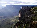
The cliffs of Mount Roraima
-
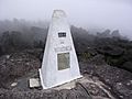
Tripoint marker on Mount Roraima, taken from the Venezuelan side
-
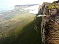
The Roraima Falls
-
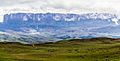
Mount Roraima and the falls as seen from the Venezuela side
-
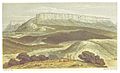
An illustration of Mount Roraima in Canoe and Camp Life in British Guiana, 1876


.jpg)


See also
 In Spanish: Roraima (tepuy) para niños
