Essequibo River facts for kids
Quick facts for kids Essequibo River |
|
|---|---|
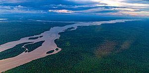
The Essequibo River in Guyana
|
|
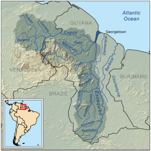
Map of the Essequibo drainage basin
|
|
| Other name(s) | Río Esequibo |
| Country | Guyana |
| Physical characteristics | |
| River mouth | Atlantic Ocean 0 ft (0 m) 7°02′N 58°27′W / 7.033°N 58.450°W |
| Length | 1,014 km (630 mi) |
| Discharge (location 2) |
|
| Basin features | |
| Basin size | 156,828 km2 (60,552 sq mi) |
| Tributaries | |
The Essequibo River is the longest and largest river in Guyana. It's so big that it's the largest river between the famous Orinoco and Amazon rivers! It starts high up in the Acarai Mountains, close to the border with Brazil. From there, it flows north for over 1,000 kilometers (about 630 miles) through thick forests and grassy plains, finally reaching the Atlantic Ocean.
When Alonso de Ojeda first explored it, he called it Río Dulce, which means Sweet River in Spanish. The Essequibo River and the land around it are managed by Guyana. However, there is a long-standing disagreement between Guyana and Venezuela about the border in this area.
Contents
River's Journey and Features
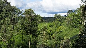
The Essequibo River flows through a special type of forest called the Guianan moist forests. This area gets a lot of rain, about 2,174 millimeters (85 inches) every year.
Along its path, the river has many exciting rapids and waterfalls. One very famous waterfall is Kaieteur Falls, which is on the Potaro River, a tributary that flows into the Essequibo.
Near where the Essequibo meets the Atlantic Ocean, its mouth is about 20 kilometers (12 miles) wide. This wide area, called an estuary, has many small islands. The river enters the Atlantic about 21 kilometers (13 miles) from Georgetown, which is the capital city of Guyana. Other notable waterfalls along the river include Murrays Fall, Pot Falls, Kumaka Falls, and Waraputa Falls.
Islands in the River
For more than 30 kilometers (19 miles) from its mouth, the river splits around large, flat, and fertile islands. These include Leguan (about 28 square kilometers or 11 square miles), Wakenaam (about 44 square kilometers or 17 square miles), and Hogg Island (about 60 square kilometers or 23 square miles).
Fort Island is located near Hogg Island. On Fort Island, you can find Fort Zeelandia. This fort was once the main government center for the country when the Dutch ruled the area. Another interesting place is Sloth Island, which is an eco-tourism spot in the river.
Amazing River Animals
The Essequibo River is home to a huge variety of animals, especially fish! More than 300 different kinds of fish live in the Essequibo basin. Almost 60 of these fish species are endemic, meaning they are found nowhere else in the world. Scientists believe there might be even more species waiting to be discovered, as some parts of the river basin haven't been fully explored yet.
For example, in 2013, surveys of the upper Mazaruni River found many new fish species. Some of these had never been described before! During big floods, the upper parts of the Essequibo River can connect with the Branco River, which is part of the Amazon basin. This connection allows some fish to travel between the two river systems.
River's Past and Discoveries
Early European Explorations
The first Europeans to see the Essequibo River were likely the ships of Juan de Esquivel in 1498. The river is named after him. In 1499, Amerigo Vespucci and Alonso de Ojeda explored the mouths of the Orinoco River and are thought to be the first Europeans to explore the Essequibo. Alonso de Ojeda famously called it "Rio Dulce" (Sweet River).
In 1596, Lawrence Kemys explored inland along the Essequibo River. He was part of Walter Raleigh's British expedition to Guiana. The next year, Kemys continued exploring the coast and the Essequibo River.
Dutch Settlements
The first European settlement in Guyana was built by the Dutch in 1615. It was located along the lower part of the Essequibo River. The Dutch colony of Essequibo was officially founded in 1616. This area later became part of British Guiana.
The Dutch colonists got along well with the Native American people living there. They started sugarcane and tobacco plantations along the riverbanks.
British Rule and Border Disputes
The Dutch managed to defend their colony from attacks by the British, French, and Spanish for almost 200 years. However, in 1814, they gave their territory to the British.
In the 19th century, Venezuela became independent. At this time, Britain needed a colony in the region for its large trading ships. Venezuela claims that the Essequibo River should be the true border between it and Guyana. However, the border was officially set between Venezuela and Britain (who then ruled Guyana) in 1899 through a special process called arbitration.
Later, a lawyer from Venezuela claimed that the judges in the arbitration had made a political deal. Because of this, Venezuela has brought back its claim to the land west of the Essequibo River.
In 1995, there was an accident involving a mining company. A large amount of waste was released into the river, which caused some environmental damage.
Exciting Expeditions
Many explorers and scientists have traveled the Essequibo River to learn more about it.
1837-1838 Expedition
A German researcher named Robert Hermann Schomburgk explored the Essequibo River. He followed its path to the southwest. He tried to find the river's source and recorded its location.
1908 Fish Expedition
In 1908, a German-American fish expert named Carl H. Eigenmann traveled on the Essequibo River and its tributary, the Potaro. He studied and described 336 different kinds of fish species living in these rivers!
1969 "Operation El Dorado"
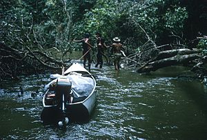
As part of a British project, geologists Dr. Jevan P. Berrangé and Dr. Richard L. Johnson created the first detailed maps of southern Guyana. They used aerial photos and then went on four expeditions to check their findings. On one trip, they explored the entire Essequibo basin. They traveled in two canoes with Amerindian guides, going up all the major rivers that flow into the Essequibo. They even found what they believed to be the true source of the Essequibo, the Chadikar River.
1971 Hovercraft Journey
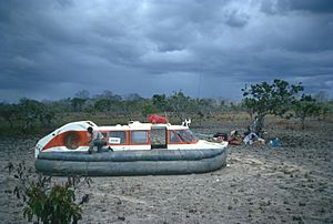
On February 26, 1971, an amazing expedition started by hovercraft from Manaus in Brazil. They traveled up rivers and even hovered across the North Savannas of Guyana. Their journey took them to the Rupununi River, then to the Essequibo River, and finally all the way down to its mouth near Georgetown.
The main goal was to film for a BBC show called "The World About Us". They also wanted to show off a new type of small hovercraft. This was the first time anyone had traveled this route by river, land, and sea from Manaus to Georgetown, covering about 1,000 miles (1,600 kilometers)!
2013 Source Discovery
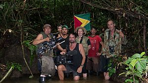
In April and May 2013, a team from Guyana and Germany went on an expedition. They followed the Sipu River to find the still-unknown source of the Essequibo. This trip was supported by the French-German TV Company ARTE. They worked with the Guyanese government and the Wai-Wai-Amerindian tribe, who live in the very south of Guyana.
With the help of the Wai-Wai people, satellite maps, and GPS, the team found the source valley in 2013. The location they found was different from what Robert Hermann Schomburgk had recorded in 1837-1838. This means more research is needed to fully understand the river's exact starting point.
2018 Furthest Source Expedition
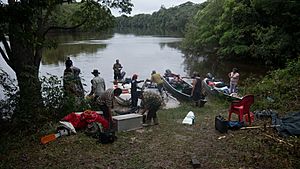
In 2018, a group of explorers, including five Wai-wai members, set out to find the furthest source of the Essequibo River. They used information from the 2013 expedition, maps, local Wai-Wai knowledge, and GPS. They followed the Sipu River until they reached the very edge of the watershed.
There, only 20 meters (about 65 feet) from the Brazilian border, they found and recorded what is now known as the furthest source of the Essequibo River. The GPS coordinates for this spot are N1'24.5243, W59'16.5107.
After finding the source, the team began the first-ever full descent of the Essequibo River. The team of nine paddled for 10 weeks, all the way to where the Essequibo meets the Atlantic Ocean.
See also
 In Spanish: Río Esequibo para niños
- Rappu Falls
 | Toni Morrison |
 | Barack Obama |
 | Martin Luther King Jr. |
 | Ralph Bunche |


