
The Guianas facts for kids
The Guianas (pronounced GEE-AH-nahs) are a special region in northeastern South America. They are located right along the Atlantic Ocean coast. This area is made up of different lands, some are independent countries, and others are territories belonging to other nations.
Geography
The Guianas sit on something called the Guiana Shield. Think of this as a very old, strong rock foundation. To the south and east, it borders Brazil. To the west, it touches Venezuela. And to the north, it meets the wide Atlantic Ocean.
The main parts of the Guianas, from west to east, are:
- Guyana: This is an independent country.
- Suriname: This is also an independent country.
- French Guiana: This land is an overseas department of France, meaning it's a part of France, but far away.
Sometimes, two other areas are also included when people talk about the Guianas:
- The Guayana Region: This is a part of southeastern Venezuela. It used to be called Spanish Guyana.
- Portuguese Guiana: This area is in northeastern Brazil. It was once part of the Portuguese Empire and is now the Brazilian state of Amapá.
History
Starting in the 1600s, countries like England, the Netherlands, France, Portugal, and Spain made these lands their colonies. This is why the Guianas are divided the way they are today. Here's how the colonies became what they are now:
- British Guiana: This became independent in 1966 and is now called Guyana.
- Spanish Guiana: This is now the southeastern part of Venezuela.
- French Guiana: This is still an overseas region and department of France.
- Dutch Guiana: This became independent in 1975 and is now called Suriname.
- Portuguese Guiana: This later became known as Brazilian Guiana and is now the Brazilian state of Amapá.
Countries
Guyana
Guyana is officially called the Co-operative Republic of Guyana. It has the Atlantic Ocean to its north. Brazil is to its south and southwest. Suriname is to its east, and Venezuela is to its west.
Guyana covers about 214,969 square kilometers (83,000 square miles). In 2016, about 735,909 people lived there. This means there were about 3.4 people per square kilometer. The main language spoken is English.
The biggest cities in Guyana (from a 2012 count) are:
- Georgetown (the capital city) with 118,363 people.
- Linden with 27,277 people.
- New Amsterdam with 17,329 people.
The highest point in Guyana is Mount Roraima. It is 2,772 meters (9,094 feet) tall. This mountain is found in the Pacaraima Mountains, which are in the southwest of the country.
The largest river is the Essequibo river. It starts in the Acarai Mountains and flows north for 1,010 kilometers (628 miles). It empties into the Atlantic Ocean about 21 kilometers (13 miles) from Georgetown.
Suriname
Suriname is officially known as the Republic of Suriname. It borders the Atlantic Ocean to the north. French Guiana is to its east, and Guyana is to its west. Brazil is to its south.
Suriname has an area of about 163,820 square kilometers (63,250 square miles). In 2016, about 585,824 people lived there. This means there were about 3.6 people per square kilometer. The official language is Dutch.
The largest cities in Suriname (from a 2012 count) are:
- Paramaribo (the capital city) with 240,924 people.
- Koewarasan with 27,713 people.
- De Nieuwe Grond with 26,161 people.
The highest point in Suriname is Julianatop. It is 1,230 meters (4,035 feet) high. This mountain is located in the Sipaliwini District, in the center of the country.
The biggest river in Suriname is the Courantyne river. It begins in the Acarai Mountains and flows north for about 724 kilometers (450 miles). It flows into the Atlantic Ocean and forms part of the border between Guyana and Suriname.
French Guiana
French Guiana is a part of France, even though it's far away in South America. It borders Suriname to the west. Brazil is to its south and east. The Atlantic Ocean is to its north.
French Guiana covers about 83,533.9 square kilometers (32,252.6 square miles). It has a population of about 252,338 people. This means there are about 3.0 people per square kilometer. The official language is French.
The largest cities in French Guiana (from 2014) are:
- Cayenne (the capital city) with 55,817 people.
- Saint-Laurent-du-Maroni with 44,169 people.
- Matoury with 31,934 people.
The highest point in French Guiana is Bellevue de l'Inini. It is 851 meters (2,792 feet) tall.
The main rivers in French Guiana are:
- The Maroni river: This river forms the border between French Guiana and Suriname. It starts in the Tumuk Humak Mountains and is 611.7 kilometers (380 miles) long.
- The Mana river: This river is 430 kilometers (267 miles) long.
- The Oyapock river: This river forms the border between French Guiana and Brazil. It is 403.4 kilometers (250.6 miles) long.
Images for kids
-
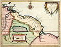
This old map from 1625 by Hessel Gerritsz shows a lake called Parime Lacus. The city of Manoa, also known as El Dorado, is shown on the west side of the lake.

See also
In Spanish: Escudo guayanés para niños
