
Paramaribo facts for kids
Quick facts for kids
Paramaribo
|
|
|---|---|

Clockwise from left: Fort Zeelandia, Garden of Palms, Arya Diwaker, Saint Peter and Paul Cathedral and its surroundings, and Mosque Keizerstraat adjacent to the Neveh Shalom Synagogue
|
|
| Nickname(s): | |

Paramaribo
Location in Suriname

Paramaribo
Location in South America
|
|
| Country | Suriname |
| District | Paramaribo District |
| Founded | 1613 |
| Area | |
| • Total | 182 km2 (70 sq mi) |
| Elevation | 3 m (10 ft) |
| Population
(2012 census)
|
|
| • Total | 240,924 |
| • Density | 1,324/km2 (3,429/sq mi) |
| Time zone | UTC-03:00 (Suriname Time) |
| • Summer (DST) | (not observed) |
Paramaribo is the capital and largest city of Suriname. It is located on the banks of the Suriname River. About 241,000 people lived here in 2012. This is almost half of Suriname's total population! The old part of Paramaribo has been a UNESCO World Heritage Site since 2002. This means it's a very special place that is protected by the world.
Contents
What's in a Name?
The city gets its name from the Paramaribo tribe. This tribe used to live near the mouth of the Suriname River. The name comes from the Tupi-Guarani languages. Para means "large river" and maribo means "inhabitants." So, it means "inhabitants of the large river."
A Look Back: Paramaribo's History

The name Paramaribo likely comes from an old native village called Parmurbo. In 1613, Dutch traders set up a trading post here. English and French traders also tried to build settlements in Suriname.
In 1650, English settlers arrived from Barbados. They built a town where Paramaribo is today. This town was protected by a fort called Fort Willoughby. In 1667, during a war, the Dutch took over Paramaribo. The fort was renamed Fort Zeelandia.
Paramaribo has always been home to many different groups of people. Among the first British settlers were many Jews. One of the oldest synagogues in the Americas, the Neveh Shalom Synagogue, is in Paramaribo. After 1873, many people who had been enslaved were allowed to leave the plantations. This caused the city's population to grow a lot.
Paramaribo has been the capital of Suriname for a long time. It was the capital when Suriname was a colony. It remained the capital when Suriname became independent in 1975. The old town has had several big fires. In 1821, over 400 buildings were destroyed. Another fire in 1832 destroyed almost 50 buildings.
In 1972, the Paramaribo Zoo opened. In 1987, the city was divided into 12 smaller areas called resorts.
Where is Paramaribo?

The city is located on the Suriname River. It is about 15 kilometers (9 miles) inland from the Atlantic Ocean. It is part of the Paramaribo district.
- Evolution of Paramaribo
-
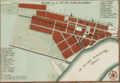
Paramaribo around 1737.
-
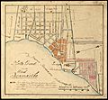
Paramaribo in 1821. The brown area shows where the fire happened that year.
-
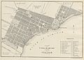
Paramaribo around 1876.
-
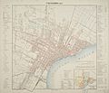
Paramaribo around 1916–1917.

.jpg)

.jpg)
Paramaribo's Climate
Paramaribo has a tropical rainforest climate. This means it's warm and rainy all year round. There isn't a true dry season. Every month gets more than 60 millimeters (2.4 inches) of rain. The driest time of year is from September to November. The heaviest rain falls from April to July.
Temperatures stay pretty much the same all year. The average high temperature is about 30 degrees Celsius (86°F). The average low temperature is around 24 degrees Celsius (75°F). Paramaribo gets about 2135 millimeters (84 inches) of rain each year.
| Climate data for Paramaribo (Zorg en Hoop Airport) (1991–2020) | |||||||||||||
|---|---|---|---|---|---|---|---|---|---|---|---|---|---|
| Month | Jan | Feb | Mar | Apr | May | Jun | Jul | Aug | Sep | Oct | Nov | Dec | Year |
| Mean daily maximum °C (°F) | 29.2 (84.6) |
29.4 (84.9) |
28.7 (83.7) |
29.9 (85.8) |
30.0 (86.0) |
30.2 (86.4) |
30.7 (87.3) |
31.5 (88.7) |
32.0 (89.6) |
32.1 (89.8) |
31.2 (88.2) |
30.0 (86.0) |
30.4 (86.7) |
| Daily mean °C (°F) | 27.1 (80.8) |
27.3 (81.1) |
27.7 (81.9) |
27.9 (82.2) |
27.6 (81.7) |
27.4 (81.3) |
27.8 (82.0) |
28.7 (83.7) |
29.3 (84.7) |
29.3 (84.7) |
28.5 (83.3) |
27.5 (81.5) |
28.0 (82.4) |
| Mean daily minimum °C (°F) | 24.1 (75.4) |
23.2 (73.8) |
23.5 (74.3) |
24.5 (76.1) |
23.7 (74.7) |
24.4 (75.9) |
24.4 (75.9) |
24.6 (76.3) |
25.1 (77.2) |
25.1 (77.2) |
24.8 (76.6) |
24.2 (75.6) |
24.3 (75.7) |
| Average precipitation mm (inches) | 172.7 (6.80) |
146.2 (5.76) |
130.5 (5.14) |
215.8 (8.50) |
306.6 (12.07) |
295.6 (11.64) |
234.3 (9.22) |
147.7 (5.81) |
90.3 (3.56) |
86.5 (3.41) |
125.7 (4.95) |
183.7 (7.23) |
2,135.5 (84.07) |
| Average precipitation days (≥ 3.0 mm) | 15 | 12 | 14 | 16 | 22 | 22 | 20 | 15 | 11 | 12 | 13 | 18 | 190 |
| Average relative humidity (%) | 76.1 | 74.4 | 73.2 | 76.2 | 79.4 | 80.2 | 77.4 | 74.0 | 70.9 | 71.0 | 75.6 | 78.3 | 75.6 |
| Source 1: NOAA | |||||||||||||
| Source 2: World Meteorological Organization (Average precipitation days) | |||||||||||||
Who Lives in Paramaribo?
| Historical population | ||
|---|---|---|
| Year | Pop. | ±% p.a. |
| 1790 | 18,000 | — |
| 1831 | 15,265 | −0.40% |
| 1853 | 16,031 | +0.22% |
| 1980 | 167,798 | +1.87% |
| 1995 | 228,551 | +2.08% |
| 2004 | 242,946 | +0.68% |
| 2012 | 240,924 | −0.10% |
In 2012, Paramaribo had 240,924 people. The number of people living in the city has stayed about the same recently. However, many towns nearby are growing.
Paramaribo is famous for its many different ethnic groups. About 27% of people are Creoles. These are people of African or mixed African-European descent. About 23% are East Indian. About 18% are Multiracial. There are also Maroons (descendants of escaped enslaved Africans), Javanese, Indigenous people, and Chinese. Smaller groups include Europeans, Lebanese, and Jews. In recent years, many Brazilians, Guyanese, and new Chinese immigrants have moved to Paramaribo.
Paramaribo's Economy

.jpg)
Paramaribo is the main business and financial center of Suriname. The city itself doesn't produce many goods. But almost all the money from Suriname's main exports goes through Paramaribo. These exports include gold, oil, bauxite, rice, and tropical wood. All the banks, insurance companies, and other financial businesses are located here. About 75% of Suriname's total income is spent in Paramaribo.
Tourism is also becoming very important. Most visitors come from the Netherlands.
Getting Around Paramaribo

.jpg)

Paramaribo has two airports: Johan Adolf Pengel International Airport and Zorg en Hoop Airport. Johan Adolf Pengel is for international flights. Zorg en Hoop is for local flights.
The Jules Wijdenbosch Bridge connects Paramaribo to Meerzorg. This bridge goes over the Suriname River. The Jules Sedney Harbour is the main port for cargo ships. The old harbor at Waterkant is used by ferries.
Many airlines, like Gum Air and Blue Wing Airlines, have their main offices at Zorg en Hoop Airport.
Learning in Paramaribo
The main place for higher education in Paramaribo is Anton de Kom University of Suriname. It is the only university in the country.
Healthcare in Paramaribo

Paramaribo has four hospitals. These include the Academic Hospital Paramaribo, 's Lands Hospitaal, Sint Vincentius Hospital, and Diakonessenhuis.
Paramaribo's Historic Inner City
| UNESCO World Heritage Site | |
|---|---|
.jpg)
Colonial style houses along the Waterkant in Paramaribo.
|
|
| Criteria | Cultural: ii, iv |
| Inscription | 2002 (26th Session) |
| Area | 30 ha |
| Buffer zone | 60 ha |
The old part of Paramaribo was built by the Dutch in the 1600s and 1700s. In 2002, it was named a UNESCO World Heritage Site. This historic area is along the left bank of the Suriname River. The original buildings and street layout are still mostly the same. They have been well-preserved.
Famous Places to See
.jpg)
.jpg)


Here are some important landmarks in Paramaribo:
- Fort Zeelandia
- Presidential Palace of Suriname
- Roman Catholic St Peter and St Paul Cathedral
- Suriname Mosque
- National Assembly of Suriname
- Neveh Shalom Synagogue
- The Arya Diwaker Hindu Temple
- Garden of Palms, a beautiful garden behind the presidential palace
- Centrumkerk (Central Church)
- Kwakoe, a statue remembering the end of slavery
Famous People from Paramaribo
Many notable people come from Paramaribo, including:
- Ashwin Adhin (born 1980), a politician who was Vice President of Suriname.
- Regi Blinker, a football player.
- Remy Bonjasky, a kickboxer.
- Edgar Davids, a famous football player.
- Jimmy Floyd Hasselbaink, another well-known football player.
- Ruth Jacott, a singer who represented the Netherlands in Eurovision.
- Jeangu Macrooy, a singer who also represented the Netherlands in Eurovision.
- Clarence Seedorf, a very famous football player.
- Aron Winter, a football player.
Sister Cities
Paramaribo is connected to other cities around the world. These are called "twin towns" or "sister cities."
 Antwerp, Belgium
 Hangzhou, China
 Willemstad, Curaçao, Netherlands
 Yogyakarta, Indonesia
 Miami-Dade County, Florida, United States
See also
 In Spanish: Paramaribo para niños
