
Cayenne facts for kids
Quick facts for kids
Cayenne
|
||
|---|---|---|
.jpg)     From top to bottom, left to right: View of the Mount and Fort Cépérou, Place des Palmistes, French Guiana Prefecture Building, Place Léoplod-Héder, City Hall
|
||
|
||

Location of the commune (in red) within French Guiana
|
||
| Country | France | |
| Overseas region and department | French Guiana | |
| Arrondissement | Cayenne | |
| Intercommunality | CA Centre Littoral | |
| Area
1
|
23.60 km2 (9.11 sq mi) | |
| • Urban
(2020)
|
206.9 km2 (79.9 sq mi) | |
| • Metro
(2020)
|
5,087 km2 (1,964 sq mi) | |
| Population
(2021)
|
63,468 | |
| • Density | 2,689.3/km2 (6,965.3/sq mi) | |
| • Urban
(Jan. 2021)
|
125,552 | |
| • Urban density | 606.82/km2 (1,571.7/sq mi) | |
| • Metro
(Jan. 2021)
|
151,103 | |
| • Metro density | 29.7038/km2 (76.932/sq mi) | |
| Demonym(s) | Cayennais | |
| Time zone | UTC−03:00 | |
| INSEE/Postal code |
97302 /97300
|
|
| 1 French Land Register data, which excludes lakes, ponds, glaciers > 1 km2 (0.386 sq mi or 247 acres) and river estuaries. | ||

Cayenne is the capital city of French Guiana. French Guiana is a part of France located in South America. Cayenne is also the main city of the region.
The city is built on what used to be an island. It sits at the mouth of the Cayenne River, right on the Atlantic Ocean coast. Cayenne's motto is "fert aurum industria," which means "work brings wealth." It is the biggest city in South America where French is the main language.
In 2021, about 151,103 people lived in the wider Cayenne area. Out of these, 63,468 people lived in the city of Cayenne itself.
Contents
History of Cayenne
![]() French colonial empire 1643–1658
French colonial empire 1643–1658
![]() Dutch Empire 1658–1664
Dutch Empire 1658–1664
![]() French colonial empire 1664–1676
French colonial empire 1664–1676
![]() English Empire 1667
English Empire 1667
![]() Dutch Empire 1676
Dutch Empire 1676
![]() French colonial empire 1676–1809
French colonial empire 1676–1809
![]() Portuguese Empire 1809–1815
Portuguese Empire 1809–1815
![]() United Kingdom of Portugal, Brazil and the Algarves 1815–1817
United Kingdom of Portugal, Brazil and the Algarves 1815–1817
![]() France 1817–present
France 1817–present
Spanish explorers did not settle in this area because it was too hot. The French first tried to build a settlement in 1604. However, the Portuguese quickly destroyed it.
French settlers came back in 1643 and founded Cayenne. But they had to leave again after attacks from local tribes. In 1664, France finally made a lasting settlement in Cayenne.
Over the next ten years, the colony was controlled by the French, Dutch, and English. Eventually, it was given back to France. In 1809, forces from England and Portugal took control. It was managed by Brazil until 1814, when France got it back. From 1854 to 1938, Cayenne was used as a place where France sent prisoners.

The number of people living in Cayenne has grown a lot over time. Many people have moved there, especially from the West Indies and Brazil. Also, many babies are born in the city.
Geography of Cayenne
Cayenne is located on the estuary (where a river meets the sea) of the Cayenne River. It is on the Atlantic Ocean. The city covers part of Cayenne Island.
It is about 268 kilometers (166 miles) from Saint-Laurent-du-Maroni. It is also 64 kilometers (40 miles) from Kourou.
Here are some distances to other cities:
- Paris: 7,100 km (4,412 miles).
- Fort-de-France, capital of Martinique: 1,500 km (932 miles).
- Paramaribo, capital of Suriname: 342 km (213 miles) to the northwest.
- Macapá, Brazil: 554 km (344 miles) to the southeast.

.jpg)
How Cayenne is Governed

Cayenne is a commune (like a town or city) in France. It is run by a mayor and a city council. The current mayor is Sandra Trochimara. She became mayor in October 2020.

The city of Cayenne is not very big. So, it works with five nearby towns to form a group called the communauté d'agglomération du Centre Littoral. This group helps manage things like trash collection, water, city planning, and public transport.
Population Growth
The number of people living in Cayenne has changed over the years.
|
|
||||||||||||||||||||||||||||||||||||||||||||||||||||||||||||||||||||||||||||||
Who Lives in Cayenne?
In 2012, here's where people in the wider Cayenne area were born:
- 56.5% were born in French Guiana.
- 12.0% were born in mainland France.
- 3.0% were born in Martinique.
- 1.4% were born in Guadeloupe.
- 26.7% were born in other countries. Many of these came from Haiti and Brazil.
Economy of Cayenne

Cayenne is an important port city in South America. The main port, Dégrad des Cannes, is on the Mahury River estuary.
Cayenne exports things like wood, rosewood oil, rum, and gold. In the 1960s, people started growing sugarcane and pineapple around the city. Factories were built to can pineapples and process shrimp.
A road along the sea connects Cayenne to its suburbs, Chaton and Montabo. Important buildings in the city include the Church of the Holy Saviour and a government building on the Place d'Armes. The Cayenne – Félix Eboué Airport is the only international airport for Cayenne.

Climate in Cayenne
Cayenne has a tropical monsoon climate. This means it is hot and wet for most of the year. The average high temperature is about 30°C (86°F), and the average low is about 23°C (73°F).
The city gets a lot of rain, about 3,500 millimeters (138 inches) each year. Cayenne has a very long wet season and a very short dry season. The dry season is only from August to October. Even during the dry season, there is some rain.
| Town | Sunshine (hours/yr) |
Rain (mm/yr) |
Snow (days/yr) |
Storm (days/yr) |
Fog (days/yr) |
|---|---|---|---|---|---|
| National average | 1,973 | 770 | 14 | 22 | 40 |
| Cayenne | 2,072 | 3,515.6 | 0 | 39.7 | 34.1 |
| Paris | 1,661 | 637 | 12 | 18 | 10 |
| Nice | 2,724 | 767 | 1 | 29 | 1 |
| Strasbourg | 1,693 | 665 | 29 | 29 | 56 |
| Brest | 1,605 | 1,211 | 7 | 12 | 75 |
| Climate data for Cayenne (CAY, altitude 4m, 1991–2020 normals, extremes 1948–present) | |||||||||||||
|---|---|---|---|---|---|---|---|---|---|---|---|---|---|
| Month | Jan | Feb | Mar | Apr | May | Jun | Jul | Aug | Sep | Oct | Nov | Dec | Year |
| Record high °C (°F) | 32.5 (90.5) |
32.3 (90.1) |
32.2 (90.0) |
33.0 (91.4) |
33.2 (91.8) |
33.9 (93.0) |
34.5 (94.1) |
35.0 (95.0) |
35.2 (95.4) |
35.1 (95.2) |
34.6 (94.3) |
34.1 (93.4) |
35.2 (95.4) |
| Mean daily maximum °C (°F) | 29.3 (84.7) |
29.3 (84.7) |
29.7 (85.5) |
30.0 (86.0) |
30.1 (86.2) |
30.5 (86.9) |
31.1 (88.0) |
31.8 (89.2) |
32.4 (90.3) |
32.5 (90.5) |
31.7 (89.1) |
30.3 (86.5) |
30.7 (87.3) |
| Daily mean °C (°F) | 26.4 (79.5) |
26.4 (79.5) |
26.7 (80.1) |
26.9 (80.4) |
26.8 (80.2) |
26.8 (80.2) |
26.8 (80.2) |
27.2 (81.0) |
27.4 (81.3) |
27.5 (81.5) |
27.2 (81.0) |
26.7 (80.1) |
26.9 (80.4) |
| Mean daily minimum °C (°F) | 23.4 (74.1) |
23.5 (74.3) |
23.6 (74.5) |
23.8 (74.8) |
23.6 (74.5) |
23.0 (73.4) |
22.5 (72.5) |
22.5 (72.5) |
22.5 (72.5) |
22.4 (72.3) |
22.7 (72.9) |
23.2 (73.8) |
23.1 (73.6) |
| Record low °C (°F) | 17.4 (63.3) |
18.9 (66.0) |
18.5 (65.3) |
19.0 (66.2) |
18.8 (65.8) |
18.9 (66.0) |
19.0 (66.2) |
19.0 (66.2) |
18.7 (65.7) |
18.6 (65.5) |
17.2 (63.0) |
18.8 (65.8) |
17.2 (63.0) |
| Average precipitation mm (inches) | 399.4 (15.72) |
334.8 (13.18) |
315.4 (12.42) |
443.2 (17.45) |
600.0 (23.62) |
392.2 (15.44) |
262.2 (10.32) |
135.4 (5.33) |
63.2 (2.49) |
54.9 (2.16) |
135.2 (5.32) |
352.3 (13.87) |
3,488.2 (137.33) |
| Average precipitation days (≥ 1.0 mm) | 22.8 | 20.5 | 20.4 | 22.1 | 26.6 | 25.2 | 21.2 | 14.0 | 6.4 | 6.4 | 12.4 | 21.5 | 219.6 |
| Average relative humidity (%) | 82 | 80 | 82 | 84 | 85 | 82 | 78 | 74 | 71 | 71 | 76 | 81 | 79 |
| Mean monthly sunshine hours | 102.4 | 90.2 | 117.3 | 121.1 | 121.4 | 153.2 | 200.1 | 231.3 | 250.8 | 256.6 | 208.1 | 150.3 | 2,002.8 |
| Source: Meteo France | |||||||||||||
| Climate data for Cayenne (Suzuni, altitude 4m, 1991−2020 normals, extremes 1972−present) | |||||||||||||
|---|---|---|---|---|---|---|---|---|---|---|---|---|---|
| Month | Jan | Feb | Mar | Apr | May | Jun | Jul | Aug | Sep | Oct | Nov | Dec | Year |
| Record high °C (°F) | 31.4 (88.5) |
31.9 (89.4) |
32.2 (90.0) |
34.0 (93.2) |
33.4 (92.1) |
33.5 (92.3) |
34.4 (93.9) |
33.3 (91.9) |
34.4 (93.9) |
33.7 (92.7) |
33.6 (92.5) |
33.3 (91.9) |
34.4 (93.9) |
| Mean daily maximum °C (°F) | 28.7 (83.7) |
28.7 (83.7) |
29.0 (84.2) |
29.3 (84.7) |
29.2 (84.6) |
29.4 (84.9) |
30.0 (86.0) |
30.4 (86.7) |
30.7 (87.3) |
30.9 (87.6) |
30.4 (86.7) |
29.5 (85.1) |
29.7 (85.5) |
| Daily mean °C (°F) | 26.5 (79.7) |
26.5 (79.7) |
26.8 (80.2) |
27.1 (80.8) |
26.8 (80.2) |
26.5 (79.7) |
26.6 (79.9) |
27.0 (80.6) |
27.4 (81.3) |
27.7 (81.9) |
27.5 (81.5) |
27.0 (80.6) |
27.0 (80.6) |
| Mean daily minimum °C (°F) | 24.2 (75.6) |
24.4 (75.9) |
24.7 (76.5) |
24.8 (76.6) |
24.3 (75.7) |
23.6 (74.5) |
23.3 (73.9) |
23.7 (74.7) |
24.1 (75.4) |
24.5 (76.1) |
24.6 (76.3) |
24.5 (76.1) |
24.2 (75.6) |
| Record low °C (°F) | 20.3 (68.5) |
20.5 (68.9) |
21.4 (70.5) |
21.2 (70.2) |
21.2 (70.2) |
20.5 (68.9) |
20.4 (68.7) |
20.3 (68.5) |
20.3 (68.5) |
20.8 (69.4) |
20.5 (68.9) |
20.1 (68.2) |
20.1 (68.2) |
| Average precipitation mm (inches) | 370.9 (14.60) |
248.8 (9.80) |
259.8 (10.23) |
355.3 (13.99) |
517.9 (20.39) |
373.6 (14.71) |
155.2 (6.11) |
79.1 (3.11) |
39.3 (1.55) |
51.5 (2.03) |
104.8 (4.13) |
259.6 (10.22) |
2,815.8 (110.86) |
| Average precipitation days (≥ 1.0 mm) | 20.5 | 16.2 | 16.6 | 19.0 | 24.3 | 23.4 | 15.5 | 8.8 | 5.0 | 6.3 | 10.8 | 18.9 | 185.1 |
| Source: Météo-France | |||||||||||||
Historical Buildings and Places
Saint-Sauveur Cathedral

Work on the Saint-Sauveur Cathedral began in 1825 and finished in 1833. It was officially opened in 1861. This church is now a recognized French historical monument.
In 1933, the church became a cathedral. It was blessed in 1934 by the first bishop of Guyana. During renovations in the 1950s, workers found a lead box with old coins inside. The bell tower was also fixed up in 2000-2001.
Fort Cépérou
Fort Cépérou is a old fort from the 1600s. It was first called Fort Saint-Michel. It is on Mount Cépérou, named after a local chief. This chief sold the land for the fort in 1643.
-
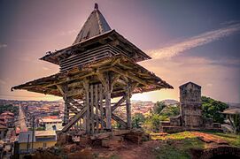
View of Cayenne from Fort Cépérou with belfry in foreground, May 2015.
-
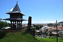
View of the renovated pagoda
-
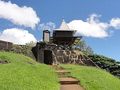
Fort Cépérou


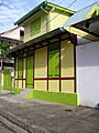
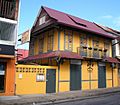
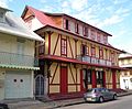
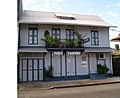
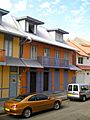
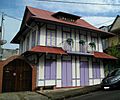
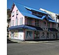
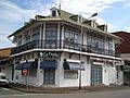
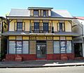
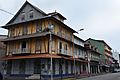
Historic Houses

Recently, the city has fixed up many old Creole houses in the city center. These houses show the unique style of the region.
-
Restored creole house on the place du Coq.
-
-
Creole house restored as restaurant.
-
Restored créole home.
-
Creole building
-
Creole home, restored.
-
Restored creole home not far from Cépérou.
-
Creole house restored as a business
-
Creole house renovated into jewelry store.
-
Direction régionale des Affaires culturelles (HQ of Regional Administration for Cultural Affairs)
-
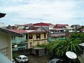
Downtown seen from the roof-tops.
-
Club Saint-Hubert in Cayenne.


Place des Palmistes
This plaza was created in 1810 after city walls were taken down. It was first called "Savanna Square." Later, royal palm trees were planted there, and it became "Royal Palms' Square."
In 1880, a bronze column was put up to remember the storming of the Bastille. The plaza was turned into a beautiful English garden with flowers and plants. A statue of Félix Éboué, a famous person from Guiana, stands there. Today, it is a lively spot where people meet. In the evenings, food carts sell snacks and local drinks.
Botanical Garden

In 1786, King Louis XVI created a garden to store and grow different plants and trees. A director named Louis Claude Richard brought plants like nutmeg, rattan, and black pepper from India. It was called the King's Garden back then.
In 1879, the park became the Botanical Garden. It is a floral park in the city center and covers three hectares (about 7.4 acres). A statue of Gaston Monnerville is in the middle of the garden.
Market and Place du Coq


These two places are near Cayenne's old port. A market square existed here as early as 1703. In 1888, a covered market was built. In 1907, the city decided to build a new, bigger covered market, which is still there today.
In 1920, a war memorial for the First World War was put up where the old market was. It has a rooster on top, which gave the place its current name, Place du Coq (Rooster Square).

Chinese Village (Village Chinois)
The Village Chinois (Chinese Village) is a neighborhood in Cayenne. It is located near the city center along the Cayenne River. Many people from other parts of French Guiana move to this area.
Culture in Cayenne
Carnival of Cayenne
The carnival is one of the biggest events in Cayenne. It happens between early January and February or March.
What is the Carnival?


This festival is a big part of Guianan Creole culture. It started from European carnival traditions. In the past, enslaved people were not allowed to join. But they secretly held their own festivals to celebrate their African roots and freedom. They also made fun of the settlers.
The last days of carnival are very special:
- Fat Sunday: This is the day of the grand parade. Groups compete for prizes with their performances.
- Fat Monday: People have "burlesque marriages." Men dress as brides, and women dress as grooms.
- Mardi Gras (Fat Tuesday): Carnival goers dress as "Diab rouj" (red devils). Everyone wears red and black.
- Ash Wednesday: People dressed in black and white bury Vaval, who is the king of the carnival.
Street Parades
Groups in costumes march to the beat of drums and brass instruments. They parade with decorated floats. These groups practice for months to perform for thousands of people watching from sidewalks and stands.
Some well-known groups are Kassialata, Reno Band, OsBand, and les Belles de la Madeleine. Brazilian bands, like those in the Rio Carnival, are popular for their music and costumes. The Asian community in Cayenne also brings dragons to the parade.
Masked Balls

Nightclubs, sometimes called "universities" during carnival, hold masked balls. Men come to dance with women called Touloulous. This tradition is unique to French Guiana.
The carnival dances include the polka, mazurka, and biguine. The Touloulous invite men to dance, and the men cannot say no. Only Touloulous are allowed to dance in costume. If a woman not in costume tries to dance, the music stops.
Since the 1990s, there are also "tololo" parties. Here, men dress up like Touloulous and invite women (who are not in costume) to dance. These parties are becoming very popular.
Family Carnival
Families get together every week to eat king cake. This is a European tradition celebrated throughout the carnival. The cake can have different fillings like frangipane, cream, or coconut.
After slavery ended in 1848, people in French Guiana often worked together on farms. The king cake tradition, also called "rend le bouquet," started around this time. One couple would host a meal and celebration. At the end, they would give a bouquet to another couple, who would then host the next gathering.
Main Sights in Cayenne

Cayenne's main street is Avenue Général de Gaulle. At the east end, near the coast, are the Place des Palmistes and Place de Grenoble. Many official buildings are in this area. These include the Town Hall, the Post Office, and the Préfecture (where the head of French Guiana lives).
To the west is Fort Cépérou, an old fort from the 1600s, which is mostly in ruins now. To the south are the Place du Coq and a market.
Other important places in the city include Cayenne Cathedral, the city library, and a museum about French Guianese Culture. The Jardin botanique de Cayenne is the city's botanical garden.
Transportation
Cayenne is served by the Cayenne – Félix Eboué Airport. This airport is in the nearby town of Matoury.
French Guiana's main seaport is Dégrad des Cannes. It is located on the Mahury River estuary, in the town of Remire-Montjoly. Most of French Guiana's goods that come in or go out pass through this port. It was built in 1974 to replace the old, crowded harbor in Cayenne.
Cayenne is connected to Saint-Laurent-du-Maroni by Route nationale 1. It is connected to Saint-Georges by Route nationale 2.
Education
Cayenne is home to the University of French Guiana. This university became a separate institution in 2014.
Notable People from Cayenne
- Léon Damas, a famous poet and politician.
- Gaston Monnerville, a well-known politician.
- Henri Salvador, a comedian and singer.
- Christiane Taubira, a politician.
- Mike Maignan, a footballer.
See also
 In Spanish: Cayena para niños
