West Indies facts for kids
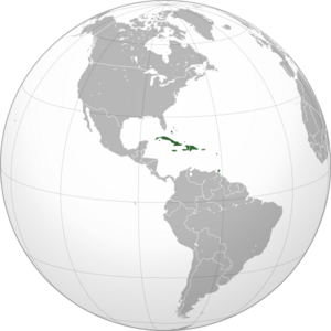
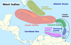
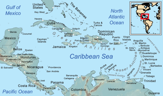
The West Indies is a group of islands in North America. It is surrounded by the North Atlantic Ocean and the Caribbean Sea. This area includes 13 independent island countries and 19 territories that belong to other countries. These islands are part of three main groups: the Greater Antilles, the Lesser Antilles, and the Lucayan Archipelago.
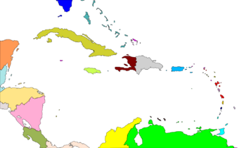
The West Indies includes all the islands in the Antilles, plus The Bahamas and the Turks and Caicos Islands. These last two are in the North Atlantic Ocean. Today, the term "West Indies" often means the same as "Caribbean". However, "Caribbean" can also include coastal parts of Central and South American countries. This includes places like Mexico, Belize, Panama, Colombia, and Venezuela. Even Bermuda, an island in the Atlantic, is sometimes grouped with the Caribbean because of its culture.
Contents
What Does "West Indies" Mean?
The word Indies comes from the Latin word India. This word referred to lands in South Asia near the Indus River. The ancient Greeks called the people from there Indoi, meaning "people of the Indus."
In 1492, Christopher Columbus sailed from Spain. He was looking for a western sea route to the Eastern world. He hoped to find a way to the rich spice markets of Asia. When he landed in the New World, he thought he had reached the eastern part of the Indies. So, Columbus called the Americas the Indias and the native people Indios (Indians).
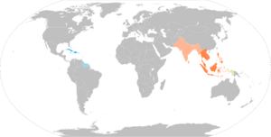
To avoid confusion, the Spanish called the lands in the East Indias Orientales (East Indies). They called the lands in the West Indias Occidentales (West Indies). At first, "West Indies" meant all of the Americas.
Different European countries controlled parts of these "Indies." In the East, there were the Spanish East Indies and the Dutch East Indies. In the West, there were the Spanish West Indies, Dutch West Indies, French West Indies, British West Indies, and Danish West Indies. Many old trading companies used "Indies" in their names, like the Dutch West India Company.
Today, the term "West Indies" is still used. For example, the West Indies cricket team represents many of these islands.
History of the West Indies
Many different cultures lived on these islands long ago. Some evidence shows people lived here as early as 6,000 BCE.
In the late 1500s, merchants and pirates from France, England, and the Netherlands came to the Caribbean Sea. They attacked Spanish and Portuguese ships and towns. They often hid in areas the Spanish could not control. These included the islands of the Lesser Antilles and the northern coast of South America.
By the mid-1600s, the "Sugar Revolution" began. Europeans started growing a lot of sugar cane. They brought thousands of enslaved Africans to work on these farms. These enslaved people changed the population of the islands. They joined or replaced the native Caribs and European workers.
The fight between European countries spread south. English, Dutch, French, and Spanish settlers, along with enslaved Africans, moved into new areas. They took over parts of The Guianas and the Orinoco River valley. The Dutch even went deep into South America, along the Orinoco and Amazon rivers.
The English from Jamaica made friends with the Miskito Kingdom in what is now Nicaragua and Honduras. They also started cutting down trees in Belize. This created a special trading and diplomatic area called the Western Caribbean Zone. In this area, many people of African descent lived, just like in other parts of the Caribbean.
From the 1600s to the 1800s, the West Indies had many European colonies. These included the French West Indies, British West Indies, Danish West Indies, Netherlands Antilles (Dutch West Indies), and Spanish West Indies.
In 1916, Denmark sold the Danish West Indies to the United States for $25 million. These islands became the United States Virgin Islands.
Between 1958 and 1962, the United Kingdom tried to unite its West Indies islands. They formed the West Indies Federation. The goal was for these islands to become one independent country. But the Federation had problems and was dissolved in 1963. Nine of its parts became independent countries, and four became British territories.
Geology and Landforms
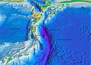
The West Indies is a complex system of islands. It has about 7,000 islands and small islets. They stretch over 3,000 kilometers (2,000 miles). They go from Florida in North America down to the northern coast of Venezuela. These islands have active volcanoes, low-lying atolls (ring-shaped coral reefs), and tall mountains. Each of the three main island groups has a different origin.
Greater Antilles: Oldest Islands
The Greater Antilles is the oldest of the three island groups. It includes the largest islands like Cuba, Jamaica, Hispaniola, and Puerto Rico. It also has the tallest mountains in the Caribbean. These islands are made of very old rocks. Some parts are from the North American Plate, over 539 million years old. Other parts are from Jurassic limestone (201.3-145 million years ago) and volcanic rocks.
The Greater Antilles started near Central America. They then moved eastward. About 56 million years ago, they crashed into the Bahama Platform. This crash caused volcanoes and lifted land, changing sea levels. These islands have been above sea level for a very long time.
Cuba has the oldest rocks in the Greater Antilles. Much of Cuba is made of karst limestone. Jamaica's Blue Mountains are made of granite. Most of Hispaniola, Puerto Rico, and the Virgin Islands were formed when the Caribbean Plate crashed into the North American Plate.
Lesser Antilles: Volcanic Islands
The Lesser Antilles is a chain of volcanic islands. They formed as the Atlantic seafloor slid under the Caribbean Plate. Most of these islands appeared less than 20 million years ago. Volcanic activity started after the Greater Antilles volcanoes stopped. It continues today. The main chain has 19 active volcanoes. It runs from Venezuela north to the Anegada Passage.
Lucayan Archipelago: Coral Reefs
The Lucayan Archipelago includes The Bahamas and the Turks and Caicos Islands. This group is a chain of barrier reefs and low islands. They sit on top of the Bahama Platform. This platform is made of marine sediments. The islands formed from sand and other materials blown by the wind. This happened during ice ages when sea levels were lower.
Countries and Territories
Caribbean (core area)
Antilles
Greater Antilles
 Cayman Islands (United Kingdom)
 Cuba
Cuba Jamaica
 Navassa Island (United States)
 Puerto Rico (United States)
- Hispaniola
Lesser Antilles
Leeward Antilles
 ABC islands
 Federal Dependencies of Venezuela (Venezuela)
 Nueva Esparta (Venezuela)
Leeward Islands
 Anguilla (United Kingdom)
 Antigua and Barbuda
 Guadeloupe (France)
- La Désirade
- Les Saintes
- Marie-Galante
 Montserrat (United Kingdom)
 Saint Barthélemy (France)
 Saint Kitts and Nevis
 Saint Martin (France)
 SSS islands
 Saba* (Netherlands)
 Sint Eustatius* (Netherlands)
 Sint Maarten (Netherlands)
- Virgin Islands
Windward Islands
 Dominica
 Grenada
- Carriacou and Petite Martinique
 Martinique (France)
 Saint Lucia
 Saint Vincent and the Grenadines
Isolated islands in the Lesser Antilles
Lucayan Archipelago
Isolated island in the Caribbean
Central America
 Belize
 Costa Rica
 Guatemala
 Honduras
 Nicaragua
 Panama
 Quintana Roo (Mexico^)
 San Andrés and Providencia (Colombia)
 Yucatán (Mexico^)
Northern America
South America
N.B.: Territories in italics are parts of transregional sovereign states or non-sovereign dependencies.
* These three Dutch Caribbean territories form the BES islands.
† Physiographically, these are continental islands not part of the volcanic Windward Islands arc. However, based on proximity, these islands are sometimes grouped with the Windward Islands culturally and politically.
~ Disputed territories administered by Colombia.
^ The United Nations geoscheme includes Mexico in Central America.
# Physiographically, Bermuda is an isolated oceanic island in the North Atlantic Ocean, not a part of the Caribbean, West Indies, North American continent or South American continent. Usually grouped with Northern American countries based on proximity; sometimes grouped with the West Indies culturally.
See also
 In Spanish: Indias Occidentales para niños
- Caribbean Basin Initiative
- Caribbean Community
- History of the British West Indies
- Spanish colonization of the Americas
 | Sharif Bey |
 | Hale Woodruff |
 | Richmond Barthé |
 | Purvis Young |


