
Hispaniola facts for kids
Hispaniola is a large island in the Caribbean Sea. It is the second biggest island in the West Indies, right after Cuba. You can find it east of Cuba and west of Puerto Rico.
Two countries share this island: Haiti is in the western part, and the Dominican Republic takes up the rest. Hispaniola is one of only two Caribbean islands that are home to two different countries. The other is Saint Martin.
| Hispaniola | |
|---|---|
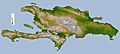
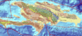
 Topographic map of Hispaniola |
|
Quick facts for kids Geography |
|
| Location | Caribbean Sea |
| Archipelago | Antilles |
| Area | 76,480 km2 (29,529 sq mi) |
| Highest point | Pico Duarte (3,087 m) |
| Countries | |
| President | Jovenel Moise |
| Capital city | Port-au-Prince (1,900,000) |
| President | Danilo Medina |
| Capital city | Santo Domingo (913,540) (Metro: 2,253,437) |
| Demographics | |
| Population | 20,113,564 (as of July 2013) |
| Density | 263 |
Contents
History of Hispaniola
Early People of Hispaniola
Long ago, before Europeans arrived, different groups of native people lived in the Caribbean islands. They came from northern South America in several waves over many centuries.
Studies of old objects and sites, called archeological studies, show that these people came to the Caribbean in four main periods.
The first group arrived around 5000 BC. They were called the Ciboney or Siboney by later groups. This name meant "man that lives among rocks." Some small groups of Ciboney were still living in western Cuba and southwestern Hispaniola when Europeans first arrived.
The second group was the Igneri. They were the first Arawak people to reach the Caribbean islands. They moved into areas where the Ciboney lived. Later, another Arawak group, the Taínos, became the main inhabitants. The Taínos lived across all the Greater Antilles, which include Cuba, Jamaica, Hispaniola, and Puerto Rico. They developed a unique culture. These were the first people the Spanish explorers met in the Americas.
The fourth and last group was the Carib. They were also Arawaks but spoke a different language. Even though they sometimes visited Puerto Rico and Hispaniola to fight the Taínos, they mainly lived in the Lesser Antilles when Christopher Columbus arrived.
When the Spanish came to Hispaniola, most of the island was home to the Taínos. Only a small part of the western tip of modern Haiti had some Ciboney groups. In the northeastern part, there was a group called the Ciguayos (sometimes Macorix). They had a similar culture to the Taínos but spoke a different language. It seems they were Carib people who adopted the Taíno culture. They were the first native people to fight against the Europeans.
European Arrival and Settlement

Christopher Columbus reached the island on December 5, 1492. He named it La Española, which means "The Spanish Island." Later, a writer named Peter Martyr d'Anghiera wrote about the island in Latin, calling it Hispaniola, meaning "Small Spain." Even though this name wasn't quite right, it became widely used in English-speaking countries because his book was translated early.
For many years, other names were also used for the island, like "Santo Domingo Island" and "Haiti."
Hispaniola was the only island Columbus visited on all four of his trips to the Americas. He first saw the island on December 5, 1492. The next day, he went ashore. The Spaniards explored the north coast of Haiti for the rest of December. On December 12, Columbus claimed the island for the King and Queen of Spain and officially named it "La Española."
On Christmas Eve, December 24, Columbus's main ship, the "Santa María," was badly damaged. The next day, Christmas Day, Columbus ordered his men to use wood from the ship to build a small fort. This fort, named La Navidad (meaning "Christmas"), was the first European building in the Americas. Columbus left 39 men there because his other two ships didn't have enough space for everyone.
From La Navidad, they traveled east along the north coast. In Samaná, they had a small fight with some native people (Ciguayos, not Taínos). Columbus named this area "Golfo de las Flechas" (Gulf of the Arrows), but today it's known as "Samaná Bay." From there, they sailed back to Spain.
When Columbus returned on his second trip in 1493, he found that La Navidad had been destroyed by the native people, and all the Spaniards were gone. He then moved east and founded the first permanent European city in the Americas, near where Puerto Plata is today. He named it "La Isabela" to honor Queen Isabella of Castile. The first Catholic mass in America was held at La Isabela on January 6, 1494. From La Isabela, Columbus sent groups to explore and take control of the island.
Because La Isabela was not a healthy place to live, Columbus's brother, Bartholomew Columbus, started a new city called La Nueva Isabela on the south coast, by the Ozama River. After a hurricane destroyed it, the city was rebuilt on the other side of the river and renamed Santo Domingo. It is the oldest continuously inhabited European city in the Americas.
The number of Taíno people on the island quickly dropped. This was due to new diseases like smallpox and difficult conditions imposed by the Spaniards. Although some black people were brought from Spain as early as 1501, the colony began to bring many more African people to work when they started growing sugar cane around 1516 to produce sugar.
Spain continued to explore and conquer new parts of the Americas. These new areas often had more gold, which made them more interesting to the Spanish. As a result, the population of Hispaniola grew very slowly. By the early 1600s, the island and nearby smaller islands, especially Tortuga, became popular spots for pirates. In 1606, the King of Spain ordered everyone on Hispaniola to move closer to Santo Domingo. This was to prevent them from interacting with pirates and Protestant groups. This decision led to French, British, and Dutch pirates setting up bases on the abandoned northern and western coasts of the island.
In 1665, the French King Louis XIV officially recognized the French presence on the island. He appointed Bertrand d'Ogeron as the governor of the western part of Hispaniola, which the French called Saint-Domingue. By the Treaty of Ryswick, Spain officially gave the western third of the island to France and kept the eastern part. The French colony of Saint-Domingue grew very quickly, becoming the richest colony in the Caribbean. The eastern Spanish colony of Santo Domingo remained less developed and had a much smaller population.
Geography of Hispaniola
The island of Hispaniola covers an area of 76,480 km2 (29,530 sq mi). As mentioned, it is divided into two countries: Haiti in the west and the Dominican Republic in the east. They share a border that is mostly artificial, except in the far north and south where rivers like the Dajabón and Pedernales form the boundary.
| Country | Population (July 2007 est.) |
Area (km²) |
Density (per km²) |
| Haiti | 9,893,934 | 27,750 | 357 |
| Dominican Republic | 10,219,630 | 48,730 | 210 |
| Total | 20,113,564 | 76,480 | 263 |
Hispaniola is separated from Cuba by the Windward Passage, which is about 81 km wide. The Jamaica Channel, about 186 km wide, separates it from Jamaica. The Mona Channel, about 112 km wide, lies between Hispaniola and Puerto Rico.
The island stretches about 650 km from east to west. Its widest point, from north to south, is about 265 km. The highest point on the island, and in the entire Caribbean, is Duarte Peak (Pico Duarte) in the Dominican Republic, standing at 3,087 meters. The lowest point is in Lake Enriquillo, which is about 46 meters below sea level.
Islands Near Hispaniola
Many smaller islands surround Hispaniola. The largest ones include:
- Gonâve (French: Île de la Gonâve): Located in the Gulf of Gonâve, this island is part of Haiti and covers 743 km². Its old Taíno name was Guanabo.
- Tortuga (French: Île de la Tortue): This island is off the northern coast of Haiti in the Atlantic Ocean. It's part of Haiti and has an area of 180 km². Its Taíno name was Baynei. It's famous for being a hideout for many pirates.
- Saona: Found off the southeastern coast of Hispaniola in the Caribbean Sea. It belongs to the Dominican Republic and is 117 km² large. Its Taíno name was Iai or Adamanay. Columbus named it Savona, but the 'v' was dropped over time.
- Île à Vache (or Île-à-Vaches): This island is off the southwestern coast of Hispaniola and is part of Haiti. It has an area of 52 km². Its Taíno name was Iabaque.
- Beata: Located off the southern coast of Hispaniola in the Caribbean Sea. It's part of the Dominican Republic and is 27 km² in size. Its Taíno name is unknown. Columbus named it Madama Beata.
- Cayemites: These are two islands, Petite Cayemite and Grand Cayemite, in the Gulf of Gonâve. They are part of Haiti and have a total area of 45 km². Their Taíno name was Cahaimi.
- Catalina: Very close to the southeastern coast of Hispaniola in the Caribbean Sea. It's part of the Dominican Republic and is 9.6 km² large. Its Taíno name was Iabanea. Columbus named it Santa Catalina.
- Navassa (French: La Navasse): Located in the Jamaica Channel, this island is 5.2 km² and is managed by the U.S. Fish and Wildlife Service. Haiti also claims it.
Mountains and Valleys
Hispaniola is a very mountainous island, home to the highest peaks in the West Indies. Most mountain ranges run from northwest to southeast, except in the southern peninsula of Haiti, where they run west to east. These mountains are separated by valleys that generally follow the same direction.
Here are some of the main mountain ranges and valleys:
- Cordillera Septentrional (Northern Range): This range is in the Dominican Republic and extends to Tortuga Island and the Samaná Peninsula. Its highest point is Diego de Ocampo, at 1,249 meters.
- The Plaine du Nord (Haiti) and Cibao Valley (Dominican Republic): This is the largest and most important valley on the island, stretching from northern Haiti to Samaná Bay.
- The Massif du Nord (Haiti) and Cordillera Central (Dominican Republic): These ranges contain the highest mountains in the West Indies, including Duarte Peak (3,087 m).
- The Plateau Central (Haiti), San Juan Valley, and Plain of Azua (Dominican Republic): These are large valleys with elevations from sea level up to 600 meters.
- The Cul-de-Sac (Haiti) or Hoya de Enriquillo (Dominican Republic): This is a unique valley, mostly low-lying, with parts below sea level. It contains two large salt lakes: Êtang Saumatre in Haiti and Lake Enriquillo in the Dominican Republic.
- Massif de la Hotte and Massif de la Selle: These are in the Southern Peninsula. Pic Macaya (2,405 m) is in Massif de la Hotte, and Pic or Morne La Selle (2,680 m) is the highest mountain in Haiti. The Massif de la Selle is called Sierra de Bahoruco in the Dominican Republic.
Rivers and Lakes
The longest rivers of Hispaniola begin in the mountains of the Cordillera Central (Dominican Republic) and Massif du Nord (Haiti).
The 10 longest rivers on the island are:
- Artibonite: The longest river on the island and in Haiti, it is 321 km long. It flows into the Gulf of Gonâve.
- Yaque del Norte: At 296 km, it's the second longest river on the island and the longest in the Dominican Republic. It flows into the Atlantic Ocean.
- Yuna: This river is 209 km long and flows east into Samaná Bay.
- Yaque del Sur: It is 183 km long and flows south into the Caribbean Sea.
- Trois Rivières (Three Rivers): This river is 150 km long and flows into the Atlantic Ocean.
- Ozama: It is 148 km long and flows into the Caribbean Sea.
- Camú: This river is 137 km long and flows into the Yuna River.
- Nizao: It is 133 km long and flows south into the Caribbean Sea.
- San Juan: This river is 121 km long and flows south into the Yaque del Sur River.
- Mao: It is 105 km long and flows north into the Yaque del Norte River.
The largest lake on Hispaniola, and in the West Indies, is Lake Enriquillo. It covers 265 km² and is a saline lake, meaning it's saltier than the sea. It is about 40 meters below sea level and has three small islands.
The second largest lake, Étang Saumâtre (also called Lake Azuei), is in Haiti, close to Lake Enriquillo. It is also a saline lake, covering about 170 km².
Other lakes include Rincón (fresh water), Oviedo (brackish water), Redonda, Limón, and Étang de Miragoâne.
Climate of Hispaniola
Hispaniola has a tropical climate. However, its weather is affected by its elevation (how high up it is) and by trade winds (winds that blow from the northeast, coming from the Atlantic Ocean). At sea level, the average temperature is around 25 °C, and it doesn't change much throughout the year. In the highest mountains, temperatures can drop to 0 °C in winter.
The island has two wet seasons: from April to June and from September to November. The driest period is from December to March.
Rainfall varies a lot across the island. Eastern areas, like the Samaná Peninsula, get over 2,000 mm of rain per year. But the southwest, like the Hoya de Enriquillo, receives less than 500 mm.
From June to November, hurricanes are common. These powerful storms can cause a lot of damage on the island.
Population of Hispaniola
As of July 2013, Hispaniola had a total population of about 20,113,564 people. This means there were about 263 people living in each square kilometer.
In Haiti, about 95% of the population is of black ethnic background. In the Dominican Republic, about 70% of the population is of black ethnic background.
In the Dominican Republic, people mainly speak Spanish. However, Haitian Creole is becoming more common due to many immigrants from Haiti. In Haiti, both French and Haitian Creole are spoken, and both are official languages.
In both countries, the main religion is Roman Catholicism. Protestant groups are also important, making up about 15% of the population in Haiti and 5% in the Dominican Republic.
The most important cities on the island are Santo Domingo (the capital of the Dominican Republic), Port-au-Prince (the capital of Haiti), Santiago (Dominican Republic), and Carrefour (Haiti).
Images for kids
-
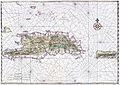
Early map of Hispaniola and Puerto Rico, c. 1639
-
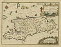
French map of Hispaniola by Nicolas de Fer
-
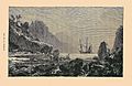
Ile de la Tortue (Tortuga island) made Hispaniola a center of pirate activity in the 17th century.
-
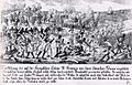
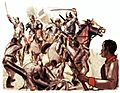
Saint-Domingue slave revolt in 1791
-
Dominican war against Haiti.
-
Topographic map
-
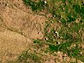
Satellite image depicting the border between Haiti (left) and the Dominican Republic (right)
-
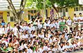
Dominican Republic people
-
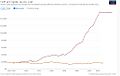
Historical GDP per capita development in the Dominican Republic and Haiti
-
Geologic map of Hispaniola.
-
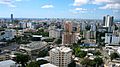
Santo Domingo in South Metro
-
Santiago de los Caballeros in Cibao North
-
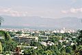
Port-au-Prince in Ouest Metro
-
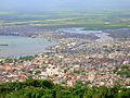
Cap Haitien in Nord
-
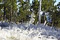
Frosted alpine forest in Constanza, Dominican Republic
-
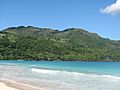
Tropical rainforest climate in Samana, Dominican Republic
-
Semi-arid climate in Pedernales, Dominican Republic
-
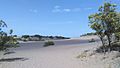
Desert sand dunes of Baní, Dominican Republic
-
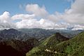
Cordillera Central in the Dominican Republic has the highest elevation of the Caribbean


_Saman%C3%A1,_DR.JPG)
.JPG)


See also
 In Spanish: La Española para niños
