
Samaná Province facts for kids
Quick facts for kids Samaná |
|
| Province | |
.jpeg) A street in Santa Barbara de Samaná
|
|
| Country | |
|---|---|
| Development region | Cibao Nordeste (III) |
| Capital | Samaná |
| - elevation | 15 m (49 ft) |
| - coordinates | 19°12′0″N 69°19′0″W / 19.20000°N 69.31667°W |
| Lowest point | Atlantic Ocean |
| - elevation | 0 m (0 ft) |
| Area | 862.8 km² (333 sq mi) |
| Population | 139,707 (2014) |
| Density | 162 /km² (420 /sq mi) |
| Province since | 1867 |
| Subdivisions | 3 municipalities 3 municipal districts |
| Congresspersons | 1 Senator 2 Deputies |
| Timezone | EST (UTC-4) |
| Area code | 1-809 1-829 1-849 |
| ISO 3166-2 | DO-20 |
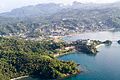
Samaná is a province in the Dominican Republic. It is located in the northeastern part of the country. The province covers the entire Samaná Peninsula. Its main city is Santa Bárbara de Samaná, often just called "Samaná". This area is one of the country's most important tourist spots. It has many popular resorts.
Contents
Understanding the Name of Samaná
The name Samaná comes from the Taíno language. Centuries ago, it was spelled Xamaná. We don't know exactly what the word means.
A Look at Samaná's History
Early Visitors and First Encounters
Christopher Columbus visited Samaná in January 1493. This was during his first trip to the Americas. At that time, the Ciguayos people lived in Samaná. They were a tribe of Native Americans. Their culture was similar to the Taínos, but they spoke a different language. They were the first native people to fight against the Europeans.
European Settlements and Runaway Slaves
After Spaniards took over the Hispaniola island, different European groups settled in Samaná. Many of these were French people. Also, groups of maroon people lived in the mountains. These were enslaved people who had escaped and lived freely.
To control these European groups, Spain built the town of Santa Bárbara de Samaná in 1756. This town was on the northern coast of Samaná Bay. People from the Canary Islands were brought to live there.
French Influence and Changes
In 1795, the eastern part of Hispaniola (the Santo Domingo colony) was given to France. The French government wanted to develop the region. Many French families moved to Samaná to grow coffee. Because of this, many places in Samaná still have French names today. Most of these French families left when Spain took back the colony in 1809.
Haitian Occupation and New Settlers
During the Haitian Occupation (1822 - 1844), a fort was built in Los Cacaos. This fort was west of Santa Bárbara de Samaná. It helped control the Samaná Bay. Another small fort was built in El Limón on the northern coast.
Jean-Pierre Boyer, who was the President of Haiti, sent some Haitian families to live in Tessón. This area is north of Santa Bárbara de Samaná. Boyer also brought former enslaved people from Philadelphia to live in the country. About 200 of them settled in Samaná. Both the Haitian and American groups kept their languages and traditions.
Modern Developments and Province Status
After the Independence of the Dominican Republic, several governments tried to sell or rent Samaná Bay. They wanted to do this with the peninsula to other countries. However, these plans never worked out.
In 1888, a railway started running. It went from Sánchez to La Vega. This railway helped connect the rich Cibao region. Sánchez became the most important port in the country for many years. The railroad was used until 1966.
Samaná became a Maritime District on June 4, 1867. This was a special type of administrative area. The 1907 Dominican Constitution changed its status to a province. It then included the municipalities of Samaná and Sánchez. In 1966, Las Terrenas became the third municipality in the province.
Later, some areas became municipal districts. El Limón became one in 2001. Arroyo Barril followed in 2003, and Las Galeras in 2005.
Where is Samaná Located?
The Atlantic Ocean is to the north and east of the peninsula and province. To the south is the Samaná Bay. Samaná shares its western borders with the Duarte and María Trinidad Sánchez provinces. It also has a short border with the Monte Plata province.
 |
Atlantic Ocean | |
||
| María Trinidad Sánchez | Atlantic Ocean | |||
| Duarte | Samaná Bay | Monte Plata |
Population of Samaná Province
In 2014, the last national census, there were 139,707 people living in Samaná province. About 44,190 people lived in towns and cities. This means about 40% of the population lived in urban areas.
The population density was about 161.9 people per square kilometer. The province's population is about 1.48% of the country's total. Samaná is the 22nd most populated province out of 31.
As of As of 2016[update], the estimated total population of the province is 108,238 people.
The largest city in the province is Samaná. It is the capital city. Its urban population in 2014 was 13,857 people.
Geography of Samaná
Mountains and Flat Lands
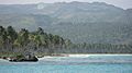
A mountain chain called Sierra de Samaná runs across the province. It goes from west to east. Only the western part, west of Sánchez, has flat land. This is because it is an estuary, where a river meets the sea. The Sierra de Samaná mountains reach the coast in most places. However, there are some areas with very nice beaches. The highest mountain in the province is in the eastern part of the peninsula. It is called La Meseta and is 650 m (2,130 ft) high.
The city of Santa Bárbara de Samaná, the provincial capital, is 15 m (49 ft) above sea level.
Rivers and Waterways
Samaná has many rivers and creeks. However, they are all very short. This is because the mountains are very close to the coast. There are more rivers on the southern side of the province. But the most important rivers are on the northern side. These are the Limón, Cantón, and San Juan rivers. They all flow into the Atlantic Ocean.
In the southwestern part of the province, you'll find the Yuna river. This is one of the most important rivers in the country. It flows into the Samaná Bay.
Climate and Weather
Samaná has a wet tropical climate. The average temperature is about 26.0 °C (78.8 °F). The yearly rainfall in the Sierra de Samaná is usually more than 2,000 mm (79 in).
Cities and Districts in Samaná
The province has 3 main municipalities and 3 municipal districts (M.D.).

| Municipality (code) |
Municipal Districts (code) | Population (2010) |
Area (km2) |
Density | Altitude (m) |
|---|---|---|---|---|---|
| Santa Bárbara de Samaná (200101) | 33,196 | 212.6 | 156.1 | 15 | |
| El Limón (200102) | 7,024 | 34.3 | 204.8 | 55 | |
| Arroyo Barril (200103) | 11,007 | 33.8 | 325.7 | 72 | |
| Las Galeras (200104) | 6,929 | 130.1 | 53.3 | 16 | |
| Samaná (200100) | 58,156 | 410.8 | 141.6 | ||
| Sánchez (200201) | 24,509 | 340.1 | 72.1 | 19 | |
| Sánchez (200200) | 24,509 | 340.1 | 72.1 | ||
| Las Terrenas (200301) | 18,829 | 111.9 | 168.3 | 17 | |
| Las Terrenas (200300) | 18,829 | 111.9 | 168.3 | ||
| Samaná (200000) | 139,707 | 862.8 | 161.9 | ||
Samaná's Economy
Farming and Fishing
The most important economic activity in Samaná is farming. Samaná is the biggest producer of coconuts in the country. However, the demand for coconuts is decreasing. Cacao and rice are also grown in the western part of the province.
Fishing used to be very important. But its importance has gone down. This is because the Yuna River has been filling the Samaná Bay with solid material.
Tourism and Whale Watching
Tourism is a very big part of the province's economy. This is thanks to the many beautiful beaches. Whale-watching is also a major activity. Many tourists come to Samaná to see humpback whales. These whales visit in late winter and early spring. They come to breed in the warm waters of the Samaná Bay.
Images for kids
-
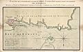
Historic map of the Samana Bay.
-
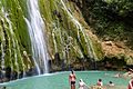
Waterfall in the Samaná Province
-
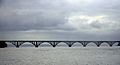
Bridge over Samana Bay.
-
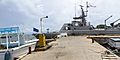
Avenida La Marina
-
View of Samana Bay
-
Rincon Bay
-
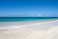
Beach in Las Terrenas


.jpg)

.jpg)
.jpg)


See also
 In Spanish: Provincia de Samaná para niños
