
Duarte Province facts for kids
Quick facts for kids Duarte |
||
| Province | ||
 |
||
|
||
| Country | ||
|---|---|---|
| Development region | Cibao Nordeste (III) | |
| Capital | San Francisco de Macorís | |
| - elevation | 110 m (361 ft) | |
| - coordinates | 19°18′0″N 70°15′0″W / 19.30000°N 70.25000°W | |
| Area | 1,649.5 km² (637 sq mi) | |
| Population | 338,649 (2014) | |
| Density | 205 /km² (531 /sq mi) | |
| Province since | 1896 | |
| Subdivisions | 7 municipalities 11 municipal districts |
|
| Congresspersons | 1 Senator 6 Representatives |
|
| Timezone | EST (UTC-4) | |
| Area code | 1-809 1-829 1-849 | |
| ISO 3166-2 | DO-06 | |

The Duarte Province is a Dominican province. It is located in the northeastern part of the country. The province is named after Juan Pablo Duarte, one of the important Founding Fathers of the Dominican Republic.
It was first created in 1896 as a "district," which was an older type of country subdivision. In 1907, the country's Constitution changed all districts into provinces. Its name was officially changed to Duarte in 1925.
Contents
Where is Duarte Province?
Duarte Province is surrounded by other provinces. To its east are the María Trinidad Sánchez and Samaná provinces. To the south, it borders the Monte Plata and Sánchez Ramírez provinces.
On its west side, you'll find the La Vega and Hermanas Mirabal provinces. To the north, it touches the Espaillat and María Trinidad Sánchez provinces again.
 |
Espaillat province | María Trinidad Sánchez province | |
|
| Hermanas Mirabal province | Samaná province | |||
| La Vega province | Sánchez Ramírez | Monte Plata province |
History of Duarte Province
The land that is now Duarte Province was once part of La Vega province until 1885. Then, it became part of Espaillat province.
In 1896, this area became its own province. It included some towns along the coast. These coastal towns are now part of the María Trinidad Sánchez province. When María Trinidad Sánchez province was created in 1959, Duarte province lost its coastal areas. This made Duarte a landlocked province, meaning it is surrounded by land on all sides.
At that time, the main towns, called municipalities, in Duarte province were San Francisco de Macorís, Castillo, Pimentel, and Villa Riva. Hostos was a smaller area called a municipal district.
Over the years, more towns became municipalities:
- Arenoso became a municipality in 1993.
- Las Guáranas became a municipality in 1998.
- Hostos, renamed Eugenio María de Hostos, became a municipality in 2004.
New municipal districts were also created:
- 1998: Agua Santa del Yuna, Cristo Rey de Guaraguao, and La Peña.
- 2000: Cenoví.
- 2003: Las Coles and Las Taranas.
- 2004: Sabana Grande.
- 2006: Barraquito, El Aguacate, Jaya, and Presidente Don Antonio Guzmán Fernández.
Population of Duarte Province
According to the last national census in 2014, about 338,649 people lived in Duarte province. About 191,878 of these people lived in towns and cities.
The population density was about 205.3 people per square kilometer. This means many people live in a small area.
Duarte province holds about 3.59% of the total population of the Dominican Republic. It is the 8th most populated province out of 31 provinces and the National District.
As of As of 2016[update], the estimated total population of the province is 295,741 people.
The largest city in the province is San Francisco de Macorís. It is the capital city and had a population of 149,508 in 2010. Other large cities include Pimentel and Castillo.
Geography of Duarte Province
Duarte province covers a total area of 1,649.5 km2 (636.9 sq mi). This is about 3.3% of the total area of the Dominican Republic. It is the 13th largest province in the country.
The province has two main geographical areas. The northern part has the Cordillera Septentrional, which means "Northern mountain range." The southern part is in the Cibao Oriental, which is the eastern part of the Cibao Valley.
There are two important roads in the province. One road comes from Moca and Salcedo. It goes southeast and then north, ending in Nagua on the northern coast.
The second road is shorter. It is a branch of the Carretera Duarte (Duarte National Road) and ends in San Francisco de Macorís.
Rivers in Duarte Province
Most rivers in Duarte province are short. They start in the Cordillera Septentrional mountains. Most of these rivers flow south and join the Camú or Yuna rivers. The Camú river is the main river that flows into the Yuna. These two rivers form the southern border of the province and flow from west to east.
Climate in Duarte Province
The climate in Duarte province is tropical. This means it is generally warm all year. However, the climate can change depending on how high up an area is. The Trade winds, which are winds from the Atlantic Ocean full of moisture, blow all year.
Because of these winds, Rain is common in this province. The northern mountains especially get a lot of rain, and you can find rainforests there.
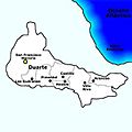
Municipalities in Duarte Province
Duarte province has 7 main towns, called municipalities, and 11 smaller areas called municipal districts (M.D.). Here is a list of the municipalities and their municipal districts:
| Municipality (code) | Municipal Districts (code) | Population (2010) |
Area (km2) |
Density | Altitude (m) |
|---|---|---|---|---|---|
| San Francisco de Macorís (060101) | 149,508 | 284.5 | 525.5 | 104 | |
| La Peña (060102) | 11,452 | 248.6 | 46.1 | 309 | |
| Cenoví (060103) | 14,689 | 92.1 | 159.5 | 64 | |
| Jaya (060104) | 5,471 | 95.8 | 57.1 | 490 | |
| Presidente Don Antonio Guzmán Fernández (060105) | 6,998 | 38.6 | 181.3 | 69 | |
| San Francisco de Macorís (060100) | 188,118 | 759.5 | 247.7 | ||
| Arenoso (060201) | 4,284 | 7.8 | 549.2 | 13 | |
| Las Coles (060202) | 6,301 | 90.7 | 69.5 | 2 | |
| El Aguacate (060203) | 3,477 | 46.2 | 75.3 | 11 | |
| Arenoso (060200)) | 14,062 | 144.7 | 97.2 | ||
| Castillo (060301) | 15,709 | 133.1 | 118.0 | 82 | |
| Castillo (060300) | 15,709 | 133.1 | 118.0 | ||
| Pimentel (060401) | 17,864 | 121.4 | 147.1 | 54 | |
| Pimentel (060400) | 17,864 | 121.4 | 147.1 | ||
| Villa Riva (060501) | 10,557 | 94.7 | 111.5 | 14 | |
| Agua Santa del Yuna (060502) | 5,175 | 37.1 | 139.5 | 5 | |
| Cristo Rey de Guaraguao (060503) | 5,335 | 78.5 | 68.0 | 128 | |
| Las Taranas (060504) | 9,833 | 86.1 | 114.2 | 34 | |
| Barraquito (060505) | 2,763 | 25.0 | 110.5 | 17 | |
| Villa Riva (060500) | 33,663 | 321.4 | 104.7 | ||
| Las Guáranas (060601) | 14,661 | 89.9 | 163.1 | 47 | |
| Las Guáranas (060600) | 14,661 | 89.9 | 163.1 | ||
| Eugenio María de Hostos (060701) | 4,123 | 61.2 | 67.4 | 31 | |
| Sabana Grande (060702) | 1,374 | 13.6 | 75.5 | 27 | |
| Eugenio María de Hostos (060700) | 5,497 | 79.4 | 69.2 | ||
| Duarte province (060000) | 289,574 | 1,649.5 | 175.6 | ||
Economy of Duarte Province
The main way people make money in Duarte province is through agriculture. Farmers grow important crops like coffee in the mountains. They also grow rice in the southern and eastern parts of the province. Cacao, which is used to make chocolate, is grown in the lower mountains and parts of the valley near the mountains.
Another important economic activity is raising cattle. There are also several industries in San Francisco de Macorís, especially those that make textiles (fabrics) and food products.
Related pages
Images for kids
-
Municipalities of Duarte Province.
-

Center of San Francisco de Macoris.


See also
 In Spanish: Provincia de Duarte para niños
