
San Francisco de Macorís facts for kids
Quick facts for kids
San Francisco de Macorís
|
||
|---|---|---|

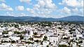
City view of San Francisco de Macoris.
|
||
|
||

San Francisco de Macorís
Location in the Dominican Republic
|
||
| Country | Dominican Republic | |
| Province | Duarte | |
| Founded | 20 September 1778 | |
| Municipality since | 1844 | |
| Area | ||
| • Total | 727.15 km2 (280.75 sq mi) | |
| Elevation | 110 m (360 ft) | |
| Population
(2022 census)
|
||
| • Total | 202,716 | |
| • Density | 278.7815/km2 (722.041/sq mi) | |
| • Demonym | Francomacorisano(a) | |
| Municipal Districts | 4 | |

San Francisco de Macorís is a lively city in the Dominican Republic. You can find it in the northeast part of the island, in a region called Cibao. It's the main city of the Duarte Province and was the sixth most populated city in the country in 2010.
The city's name comes from two parts. San Francisco is from Saint Francis, a special saint for the Franciscan Order. This was a religious group from Italy that came to this area a long time ago. The second part, Macorís, comes from the old name of the land, which was Macorix.
San Francisco de Macorís is also known as the Land of Cacao. This area grows a lot of organic cocoa, which is used to make chocolate! Because of this, the Dominican Republic is one of the top 10 countries in the world for producing cocoa beans.
Contents
A Look at San Francisco de Macorís History

A city was first started near San Francisco de Macorís way back in 1497. Later, other towns like La Vega and Cotuí were built nearby. For many years, the area that is now San Francisco de Macorís was mostly countryside, connected to these older towns.
In the early 1700s, people from Europe started investing in the area. They created a market for growing cocoa. This gave local people a new way to earn money, besides just raising animals. The cocoa business helped the community around the Santa Ana monastery grow into the city we know today. By the 1760s, this area became very important for cocoa and a popular stop for European travelers.

The town was once called Hato Grande. It later became known as the Villa of Santa Ana of San Francisco de Macorís. In 1778, some families, including the Tejada and De Jesus families, gave land for the city to be officially founded.
In 1795, a special agreement called the Treaty of Basel was made. This treaty gave the Spanish part of the island to France. When France took over in 1801, San Francisco de Macorís became a parish, which meant it could govern itself. The city's official records go all the way back to 1811.
On October 2, 1896, a leader named Ulises Heureaux reorganized the city. It became part of a larger area called "Pacificador" (meaning Peacemaker). This name lasted until July 26, 1926, when the Dominican Congress changed it to Duarte Province, which is still used today.
In 1963, the city council decided to rename the main streets of San Francisco de Macorís. This was done to honor heroes from important historical events.
Exploring San Francisco de Macorís Geography

San Francisco de Macorís is located in the northern part of the Dominican Republic, in the Cibao Region. To the north, you'll find the Septentrional Mountain Range, and to the south, the Cibao Valley. The city has hills to the north, which offer amazing views, especially at night. The Jaya River flows through the western part of the city.
City Districts
The city is divided into several smaller areas called districts. Here's a look at them:
| Division | Status | Population (2022) |
|---|---|---|
| Cenoví | District | 16,322 |
| Jaya | District | 5,529 |
| La Peña | District | 12,918 |
| Presidente Don Antonio Guzmán Fernández | District | 8,205 |
| San Francisco de Macorís | Municipal Core | 159,742 |
Land Features
The land in Duarte Province, where San Francisco de Macorís is located, varies a lot. It ranges from about 17 meters (56 feet) to 942 meters (3,091 feet) above sea level. The highest point is called "Loma Quita Espuela." People say this name comes from when the Spanish explorers were here. The hill was so steep that they had to get off their horses, take off their spurs, and walk up!
The area has different types of land. There are mountains, valleys, and areas with rich soil near rivers. Two major cracks in the Earth's crust, called faults, run through the province. These are the Septentrional fault and the Cibao fault.
Rivers and Waterways

Duarte Province has many rivers and streams. The most important ones are the Camú River and the Yuna River. These rivers and their smaller branches, like the Jaya, Cuaba, Nigua, and Payabo, are very important. They provide water for drinking and for watering crops.
Weather in San Francisco de Macorís
The temperature in San Francisco de Macorís usually stays between 17°C (63°F) and 32°C (90°F). It gets a bit cooler when it rains. The area is often called a "paradise" because it's usually not hit by hurricanes or extremely hot weather. Sometimes, there can be floods, especially during the rainy season, which happens mostly in May.
| Climate data for San Francisco de Macorís (1961–1990) | |||||||||||||
|---|---|---|---|---|---|---|---|---|---|---|---|---|---|
| Month | Jan | Feb | Mar | Apr | May | Jun | Jul | Aug | Sep | Oct | Nov | Dec | Year |
| Record high °C (°F) | 37.2 (99.0) |
35.0 (95.0) |
36.5 (97.7) |
37.4 (99.3) |
37.5 (99.5) |
37.5 (99.5) |
38.0 (100.4) |
38.5 (101.3) |
39.5 (103.1) |
39.6 (103.3) |
38.5 (101.3) |
39.5 (103.1) |
39.6 (103.3) |
| Mean daily maximum °C (°F) | 28.3 (82.9) |
28.7 (83.7) |
29.6 (85.3) |
30.5 (86.9) |
30.9 (87.6) |
31.7 (89.1) |
31.9 (89.4) |
32.0 (89.6) |
32.2 (90.0) |
31.9 (89.4) |
29.9 (85.8) |
28.6 (83.5) |
30.5 (86.9) |
| Daily mean °C (°F) | 23.0 (73.4) |
23.1 (73.6) |
23.6 (74.5) |
24.6 (76.3) |
25.4 (77.7) |
26.2 (79.2) |
26.3 (79.3) |
26.3 (79.3) |
26.4 (79.5) |
26.0 (78.8) |
24.7 (76.5) |
23.5 (74.3) |
24.9 (76.9) |
| Mean daily minimum °C (°F) | 17.7 (63.9) |
17.4 (63.3) |
17.7 (63.9) |
18.7 (65.7) |
20.0 (68.0) |
20.6 (69.1) |
20.8 (69.4) |
20.6 (69.1) |
20.5 (68.9) |
20.1 (68.2) |
19.4 (66.9) |
18.4 (65.1) |
19.3 (66.8) |
| Record low °C (°F) | 12.2 (54.0) |
12.0 (53.6) |
10.2 (50.4) |
12.3 (54.1) |
14.0 (57.2) |
16.0 (60.8) |
12.9 (55.2) |
16.0 (60.8) |
16.4 (61.5) |
16.4 (61.5) |
15.0 (59.0) |
12.7 (54.9) |
10.2 (50.4) |
| Average rainfall mm (inches) | 82.1 (3.23) |
72.8 (2.87) |
64.6 (2.54) |
97.2 (3.83) |
192.6 (7.58) |
115.8 (4.56) |
125.8 (4.95) |
163.2 (6.43) |
121.8 (4.80) |
128.1 (5.04) |
173.6 (6.83) |
110.4 (4.35) |
1,448 (57.01) |
| Average rainy days (≥ 1.0 mm) | 8.8 | 7.2 | 8.2 | 8.0 | 12.6 | 9.7 | 12.2 | 12.0 | 9.5 | 9.9 | 12.6 | 11.0 | 121.7 |
| Source: NOAA | |||||||||||||
Important Places to Visit
San Francisco de Macorís has several interesting spots:
- Estadio Julian Javier: A sports stadium.
- Casa del Morris Quezada: A historical house.
- Parque Duarte: A city park, great for relaxing.
- Catedral de Santa ana: The beautiful Santa Ana Cathedral.
The City Hall Building

The city hall of San Francisco de Macorís is where the city council meets and where the city mayor works. It's the main building for the city's government.
Santa Ana Cathedral

The Santa Ana Cathedral is a mix of old Gothic and modern building styles. It's a very large building, taking up a whole city block! It's the main church for the Obispo de la Diócesis de San Francisco (Bishop of the Diocese of San Francisco).
Connecting with San Francisco de Macorís
San Francisco de Macorís has its own ways for people to get news and information. There are several radio stations. The oldest newspaper in the city is El Jaya, which started on November 20, 1985. Its founder and director is a journalist named Adriano Cruz Marte.
Famous People from San Francisco de Macorís
Many talented people have come from San Francisco de Macorís:
- José Rafael Molina Ureña: He was the 44th President of the Dominican Republic in 1965.
- Francisco Garcia: A professional basketball player who played for the Sacramento Kings.
- Julián Javier: A famous baseball player.
- Stan Javier: Also a professional baseball player.
- Eladio Romero Santos: A music producer and singer.
- Marino Vinicio Castillo: A well-known lawyer.
- Hilma Contreras: A respected writer.
- Jackeline Estevez: A popular singer.
- Victor Martinez: A professional bodybuilder.
- Don Miguelo: A singer and writer.
- Richard Ureña: A baseball player.
- Hanser Alberto: A professional baseball player.
- Luis Kalaf: A talented composer and musician.
- Elio Rojas: A world champion boxer.
- Joel Almonó: A priest who directs the Grace Episcopal Church in Lawrence, Massachusetts.
- Marco Luciano: A baseball player.
- Johan Rojas: A professional baseball player.
Images for kids
-
City view of San Francisco de Macoris.
-
Seal of San Francisco de Macorís.
See also
 In Spanish: San Francisco de Macorís para niños
