
Cibao facts for kids
Quick facts for kids
El Cibao
|
|
|---|---|

Aerial view of Constanza, a mountain town located in the Cibao region.
|
|
| Country | Dominican Republic |
| Area | |
| • Total | 19,058.62 km2 (7,358.57 sq mi) |
| Population
(2010)
|
|
| • Total | 5,246,032 |
| • Density | 276.32/km2 (715.7/sq mi) |
| Demonym(s) | Cibaenian; Cibaine (Spanish: cibaeño) |
The Cibao, often called "El Cibao", is a large and important region in the Dominican Republic. It is located in the northern part of the country. As of 2009, over 5.6 million people lived there, making it the most populated region in the Dominican Republic.
El Cibao is a very developed area with many industries. People living here generally have high levels of education and a good quality of life. In fact, it has the highest quality of life among the three main regions of the Dominican Republic. The culture in Cibao shows a strong European influence, and it is the most successful region economically in the country.
Contents
What Does "Cibao" Mean?
The word Cibao comes from the native Taíno language. It means "stone mountain." The word is made up of "ciba" (rock or stone) and "o" (mountain). When the Spanish arrived, they used "Cibao" to describe the rich and fertile valley. This valley is found between the Central and Septentrional mountain ranges.
Geography and Economy of Cibao

El Cibao covers the central and northern parts of the Dominican Republic. To its north and east is the Atlantic Ocean. To the west, it borders Haiti, and to the south, the Central Range mountains separate it from other regions.
The Central Mountain Range is located within El Cibao. Here you'll find Pico Duarte, which is the highest mountain peak in the entire Caribbean! Two of the country's largest rivers also flow through this region. These are the Yaque del Norte, which is the longest river in the Dominican Republic, and the Yuna River.
These rivers have several dams. These dams help provide water for farming, which is a big activity here. They also create hydroelectric energy, which is clean power from water. Important crops grown in Cibao include rice, coffee, and cacao (used to make chocolate!).
The central mountains also have important mining activities. They are rich in minerals like gold, iron, and nickel. The Pueblo Viejo mine, located in Cibao, is one of the largest gold mines in the Americas. Big companies like Barrick Gold and Falconbridge help extract these valuable minerals.
Culture of El Cibao

The Cibao valley is not just a geographical area; it's also a unique cultural and linguistic place. Many people consider the Cibao region to be the cultural heart of the Dominican Republic. The way people speak here, their accent, is a mix of two old dialects. One comes from Portuguese settlers in the 16th and 17th centuries. The other comes from settlers from the Canarian Islands in the 18th century.
Merengue music, a very popular style, actually started in El Cibao. It's played using special instruments like the güira (a metal scraper), the tambora (a two-headed drum), and the accordion. The original folk style of merengue is called perico ripiao or típico. Local music groups still play this faster, traditional version of merengue today.

In late January and through February, several exciting carnivals take place in the region. The most famous carnival is in the province of La Vega. This festival dates back to the first European settlements. It began as a religious event to celebrate the time before Lent. The carnival's main theme is about good winning over evil.
Many important Dominican heroes came from Cibao. Generals José Desiderio Valverde and José Antonio Salcedo were key figures in restoring the Republic in the late 1800s. During the time of the Trujillo dictatorship, the brave Mirabal sisters secretly organized groups to fight against the unfair government. They tragically lost their lives in 1960 and are remembered as great heroes for the Dominican nation.
Most of the people in Cibao live in the central part of the region. The city of Santiago de los Caballeros is the main center. It is the biggest city and the focus of development for the entire area.
Provinces of Cibao
The Cibao region is made up of several provinces. Each province has its own capital city. Here is a list of the provinces in El Cibao:
| Province | Capital | Area (km2) | Population | Density | Map region |
|---|---|---|---|---|---|
| Dajabón | Dajabón | 1,020.73 | 62,046 | 61 | 4 |
| Duarte | San Francisco de Macorís | 1,605.35 | 483,805 | 301 | 5 |
| Espaillat | Moca | 838.62 | 425,091 | 507 | 8 |
| Hermanas Mirabal | Salcedo | 440.43 | 196,356 | 445 | 21 |
| La Vega | Concepción de la Vega | 2,287.24 | 585,101 | 556 | 13 |
| María Trinidad Sánchez | Nagua | 1,271.71 | 135,727 | 119 | 14 |
| Monseñor Nouel | Bonao | 992.39 | 367,618 | 370 | 15 |
| Monte Cristi | San Fernando de Monte Cristi | 1,924.35 | 111,014 | 58 | 16 |
| Puerto Plata | San Felipe de Puerto Plata | 1,852.90 | 312,706 | 168 | 20 |
| Samaná | Santa Bárbara de Samaná | 853.74 | 91,875 | 108 | 22 |
| Sánchez Ramírez | Cotuí | 1,196.13 | 151,179 | 126 | 23 |
| Santiago | Santiago de los Caballeros | 2,836.51 | 1,543,362 | 320 | 28 |
| Santiago Rodríguez | San Ignacio de Sabaneta | 1,111.14 | 259,629 | 234 | 29 |
| Valverde | Santa Cruz de Mao | 823.38 | 258,293 | 314 | 31 |
| Total | 19,058.62 | 5,246,690 | 165 | - |
Images for kids
-
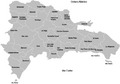
Map of the provinces of the Dominican Republic.
-
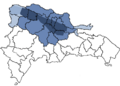
Cibao valley region.

See also
 In Spanish: Cibao para niños
