
Dajabón Province facts for kids
Quick facts for kids Dajabón |
||
| Province | ||
|
||
| Country | ||
|---|---|---|
| Development region | Cibao Noroeste (IV) | |
| Capital | Dajabón | |
| - elevation | 35 m (115 ft) | |
| - coordinates | 19°34′0″N 71°42′0″W / 19.56667°N 71.70000°W | |
| Area | 1,021.3 km² (394 sq mi) | |
| Population | 87,274 (2014) | |
| Density | 85 /km² (220 /sq mi) | |
| Province since | 1938 | |
| Subdivisions | 5 municipalities 4 municipal districts |
|
| Congresspersons | 1 Senator 2 Deputies |
|
| Timezone | EST (UTC-4) | |
| Area code | 1-809 1-829 1-849 | |
| ISO 3166-2 | DO-05 | |

Dajabón is a Dominican province located in the northwestern part of the country. It shares a border with Haiti. The capital city of the province is also called Dajabón.
The province was created in 1938 and was first named Libertador. In 1961, it was renamed Dajabón. Before becoming its own province, it was part of the Monte Cristi province.
Contents
What's in a Name?
The province gets its name from the Taíno word Dahaboon. This was the original name for the area. It was also the name of the main river in the region, the Dajabón River.
Where is Dajabón?
Dajabón province is surrounded by other provinces. To the north, it borders the Monte Cristi province. To the east, you'll find the Santiago Rodríguez province. The Elías Piña province is to the south. To the west, Dajabón shares a border with the country of Haiti.
 |
Monte Cristi | |
||
| Haiti | Santiago Rodríguez | |||
| Elías Piña |
A Look at History
For a long time, not many people lived in the Dajabón region. This was because it was on the border. First, it was between the French colony of Saint-Domingue and the Spanish colony of Santo Domingo. Later, it was between the independent countries of Haiti and the Dominican Republic.
Many battles happened here between the armies of the two parts of the island. Some important fights took place near Dajabón city during the Dominican Independence War.
In 1861, the Dominican Republic became a Spanish colony again. The Restoration War began on August 16, 1863. It started on a hill near the small village of Capotillo. The Spanish army left the country in 1865.
After this war, more people moved to the area, and new towns were formed.
When Dajabón became a province in 1938, it had three main towns, called municipalities: Dajabón, Loma de Cabrera, and Restauración. Later, Partido became a municipality in 1996. El Pino became another municipality in 2002.
The smaller local areas, called municipal districts, were created later:
- 2002: Manuel Bueno
- 2005: Cañongo and Capotillo
- 2006: Santiago de la Cruz
How Many People Live Here?
In 2014, the last time a national count was done, there were about 87,274 people living in Dajabón province. About 38,225 of these people lived in towns and cities. This means the province has about 85.5 people per square kilometer.
Dajabón province has about 0.92% of the total population of the Dominican Republic. It is the 14th most populated province out of 31.
As of As of 2016[update], it is estimated that 65,519 people live in the province.
The largest city in the province is Dajabón. In 2010, it had a population of 25,245 people.
Geography of Dajabón
The Dajabón province covers an area of about 1,021.3 km2 (394.3 sq mi). This is about 2.1% of the total area of the Dominican Republic. It is the 23rd largest province in the country. The city of Dajabón, which is the capital, is about 47 m (154 ft) above sea level.
The Cordillera Central, a mountain range, is in the southern part of the province. The northern part is mostly flat with many grassy areas called savannas. This flat area is part of the Yaque del Norte Valley.
There are two main roads in the province:
- One road goes from north to south. It starts in Monte Cristi province and passes through Dajabón, Loma de Cabrera, and Restauración. Then it continues into Elías Piña province. In some places, this road is right on the border with Haiti.
- The second main road starts in Santiago de la Cruz and goes east. It passes through Partido and El Pino. Then it goes through Santiago Rodríguez and Valverde provinces. It ends at the Carretera Duarte, which is a very important national road. This road connects Santo Domingo to Monte Cristi.
Rivers
The most important river in the province is the Dajabón River. It is also known as Masacre. This river forms part of the border between the Dominican Republic and Haiti, from the city of Dajabón to where it meets the sea. Other rivers in the province are smaller. They flow into the Dajabón River or the Artibonite River.
Climate
The climate in Dajabón province is tropical. This means it is hot for most of the year. However, it can be cooler in the mountain areas.
Towns and Districts
Dajabón province has 5 main towns, called municipalities. It also has 4 smaller areas called municipal districts (M.D.). Here are the municipalities and their municipal districts:
| Municipality (code) | Municipal Districts (code) | Population (2010) |
Area (km2) |
Density | Altitude (m) |
|---|---|---|---|---|---|
| Dajabón (050101) | 25,245 | 220.8 | 114.3 | 38 | |
| Cañongo (050102) | 2,826 | 40.2 | 70.3 | 23 | |
| Dajabón (050100) | 28,071 | 261.0 | 107.6 | ||
| Loma de Cabrera (050201) | 10,893 | 140.0 | 77.8 | 206 | |
| Capotillo (050202) | 2,112 | 57.1 | 37.0 | 200 | |
| Santiago de la Cruz (050203) | 2,619 | 48.9 | 53.6 | 280 | |
| Loma de Cabrera (050200) | 15,624 | 246.0 | 63.5 | ||
| Partido (050301) | 6,951 | 149.8 | 46.4 | 198 | |
| Partido (050300) | 6,951 | 149.8 | 46.4 | ||
| Restauración (050401) | 7,274 | 276.6 | 26.3 | 664 | |
| Restauración (050400) | 7,274 | 276.6 | 26.3 | ||
| El Pino (050501) | 4,236 | 43.9 | 96.5 | 214 | |
| Manuel Bueno (050502) | 1,799 | 44.0 | 40.9 | 309 | |
| El Pino (050500) | 6,035 | 87.9 | 68.7 | ||
| Dajabón province (050000) | 63,955 | 1,021.3 | 62.6 | ||
Economy and Trade
Like other provinces along the border with Haiti, Dajabón doesn't have a lot of big industries. Trade with Haiti is very important, especially in the city of Dajabón.
In the mountains, people grow coffee and beans. In the northern, flatter parts of the province, rice and bananas are important crops. Raising cattle (like cows) is also a big part of the economy around the city of Dajabón.
Related pages
Images for kids
-
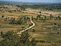
Landscape around the city of Dajabón.
-
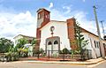
Dajabon Dominican Republic provincial town of Restauracion.
-
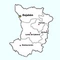
Municipalities of Dajabón Province.


See also
 In Spanish: Provincia de Dajabón para niños
