
Santiago Rodríguez Province facts for kids
Quick facts for kids Santiago Rodríguez |
||
| Province | ||
|
||
| Country | ||
|---|---|---|
| Development region | Cibao Noroeste (IV) | |
| Capital | San Ignacio de Sabaneta | |
| - elevation | 127 m (417 ft) | |
| - coordinates | 19°29′0″N 71°21′0″W / 19.48333°N 71.35000°W | |
| Area | 1,147.5 km² (443 sq mi) | |
| Population | 99,044 (2014) | |
| Density | 86 /km² (223 /sq mi) | |
| Province since | 1948 | |
| Subdivisions | 3 municipalities 0 municipal districts |
|
| Congresspersons | 1 Senator 2 Deputies |
|
| Timezone | EST (UTC-4) | |
| Area code | 1-809 1-829 1-849 | |
| ISO 3166-2 | DO-26 | |

Santiago Rodríguez is a province in the Dominican Republic. It is located in the northwestern part of the country. The capital city of this province is San Ignacio de Sabaneta. This province was officially created in 1948.
Contents
Who Was Santiago Rodríguez?
The province is named after Santiago Rodríguez. He was an important officer in the Dominican army. He fought during the Dominican-Haitian War. He also helped to found the city of Sabaneta. Santiago Rodríguez was a key military leader at the start of the Restoration War (1863-1865).
History of the Province
The main town, San Ignacio de Sabaneta, was started in 1844. It became a municipality of the Santiago province in 1854. Later, in 1879, it joined the Monte Cristi Province. Finally, in 1948, it became its own province.
Another town, Monción, was a municipality of Montecristi since 1907. In 1996, Villa Los Almácigos also became a municipality.
Where is Santiago Rodríguez Located?
Santiago Rodríguez is in a region called Línea Noroeste, which means "Northwestern Line."
- To the north, it shares borders with the Monte Cristi and Valverde provinces.
- To the east, it borders the Santiago province.
- To the south, you'll find the San Juan and Elías Piña provinces.
- To the west, it borders the Dajabón province.
Population Facts
In 2014, the last time a national count was done, there were about 99,044 people living in Santiago Rodríguez province. About 27,559 of these people lived in towns and cities.
The province's population density was about 86.3 people per square kilometer. This province has about 1.05% of the total population of the Dominican Republic. It is the 30th most populated province out of 31 provinces and the National District.
As of As of 2016[update], the estimated total population for the province is 1,015,397 people.
The biggest city in the province is San Ignacio de Sabaneta. It is the capital. In 2014, its city population was 15,648 people.
Geography and Landscape
The Santiago Rodríguez province covers a total area of about 1,147.5 km2 (443.1 sq mi). This means it makes up about 2.4% of the Dominican Republic's total area. It is the 22nd largest province in the country.
The capital city, San Ignacio de Sabaneta, is about 127 m (417 ft) above sea level.
The southern part of the province has the Cordillera Central, which is a large mountain chain. In the northern half, you'll find the Sierra Samba (also called Sierra Zamba), which is a chain of smaller hills.
The main rivers in the province are the Guayubín and Mao rivers. Both of these are tributaries that flow into the larger Yaque del Norte river.
Climate
The climate in Santiago Rodríguez province is tropical. This means it is hot for most of the year. However, it can be cooler in the mountain areas.
Municipalities
The province has 3 municipalities. It does not have any municipal districts.
- San Ignacio de Sabaneta (the capital)
- Villa Los Almácigos
- Monción

Economy
The most important economic activity in Santiago Rodríguez province is farming. People grow crops and raise animals here.
Images for kids
-

Santiago Rodríguez
-
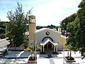
Church of San Antonio, Moncion, Dominican Republic.


See also
 In Spanish: Provincia de Santiago Rodríguez para niños
