
San Juan Province (Dominican Republic) facts for kids
Quick facts for kids San Juan |
||
| Province | ||
|
||
| Country | ||
|---|---|---|
| Development region | El Valle (VII) | |
| Capital | San Juan de la Maguana | |
| - elevation | 415 m (1,362 ft) | |
| - coordinates | 18°48′36″N 71°13′48″W / 18.81000°N 71.23000°W | |
| Area | 3,363.8 km² (1,299 sq mi) | |
| Population | 317,293 (2014) | |
| Density | 94 /km² (243 /sq mi) | |
| Province since | 1938 | |
| Subdivisions | 6 municipalities 17 municipal districts |
|
| Congresspersons | 1 Senator 5 Deputies |
|
| Timezone | EST (UTC-4) | |
| Area code | 1-809 1-829 1-849 | |
| ISO 3166-2 | DO-22 | |

San Juan is a Dominican province located in the western part of the country. Its main city, also called its capital city, is San Juan de la Maguana.
Contents
What's in a Name? The Story of San Juan
The province gets its name from its capital city, San Juan de la Maguana. The name "San Juan" is a shorter way of saying "San Juan Bautista," which means "Saint John the Baptist" in Spanish.
A Look Back: History of San Juan
For a long time, the area that is now San Juan province was part of Azua province. In 1938, a leader named Rafael Trujillo created this new province. He first named it "Benefactor." At that time, it included the towns of Las Matas de Farfán and El Cercado.
Over the years, more towns became official municipalities. Bohechío joined in 1974, Vallejuelo in 1978, and Juan de Herrera in 1992. Later, many smaller areas became "municipal districts." These are like smaller local government areas within the municipalities. For example, Matayaya became a municipal district in 1998. More districts were added between 2000 and 2007, helping to organize the province even better.
Where is San Juan Located?
The San Juan province is surrounded by other provinces. To the north, you'll find Santiago Rodríguez and Santiago provinces. To the east, it borders Azua province and a small part of La Vega. To the south, it touches Baoruco province. Finally, to the west, it shares a border with Elías Piña province.
 |
Santiago Rodríguez | Santiago | |
|
| Elías Piña | Azua | |||
| Baoruco |
People of San Juan: Population Facts
According to the last national count in 2014, there were about 317,293 people living in San Juan province. About 139,620 of these people lived in towns and cities. This means the province has about 94.3 people per square kilometer.
San Juan province holds about 3.36% of the total population of the Dominican Republic. It is the 11th most populated province out of 31, plus the National District. As of As of 2016[update], the estimated total population for the province is 226,484 people.
The biggest city in the province is San Juan de la Maguana. It is the capital and had about 71,494 people living in its urban area in 2014.
Exploring San Juan's Geography
San Juan province covers a total area of about 3,363.8 km2 (1,298.8 sq mi). This makes up about 7% of the Dominican Republic's total area. It is actually the largest province in the country by size!
The capital city, San Juan de la Maguana, is located about 418 m (1,371 ft) above sea level. This means it's quite a bit higher than coastal areas.
Mountains of San Juan
The Cordillera Central (which means "Central Mountain Chain") is a large mountain range in the northern part of the province. In the southern half, you'll find the Sierra de Neiba. The area between these two mountain ranges is known as the San Juan valley. The original Taíno people called this valley Maguana, which means "small valley."
The highest mountain in the province is Pico Duarte. It stands at 3,087 meters tall. This impressive peak is the highest mountain in the entire West Indies. It is located right on the border with Santiago province.
Rivers Flowing Through San Juan
The two most important rivers in the province are the San Juan River and the Yaque del Sur River. These rivers are vital for the local environment and communities.
San Juan's Climate
The climate in San Juan province is generally tropical. This means it is warm or hot for most of the year. However, it can be cooler in the higher mountain areas.
How San Juan is Organized: Municipalities
The province of San Juan is divided into 6 main municipalities. Within these municipalities, there are also 17 smaller areas called municipal districts (M.D.).

Here is a table showing the municipalities and their municipal districts, along with their populations and areas:
| Municipality (code) |
Municipal Districts (code) | Population (2010) |
Area (km2) |
Density | Altitude (m) |
|---|---|---|---|---|---|
| San Juan de la Maguana (220101) | 78,313 | 248.6 | 315.0 | 418 | |
| Pedro Corto (220102) | 6,891 | 146.3 | 47.1 | 506 | |
| Sabaneta (220103) | 5,621 | 480.4 | 11.7 | 706 | |
| Sabana Alta (220104) | 3,241 | 31.4 | 103.2 | 368 | |
| El Rosario (220105) | 7,426 | 204.9 | 36.2 | 381 | |
| Hato del Padre (220106) | 5,811 | 58.8 | 98.8 | 470 | |
| Guanito (220107) | 3,670 | 83.3 | 44.1 | 384 | |
| La Jagua (220108) | 3,855 | 69.2 | 55.7 | 592 | |
| Las Maguanas-Hato Nuevo (220109) | 5,192 | 72.1 | 72.0 | 523 | |
| Las Charcas de María Nova (220110) | 3,166 | 86.8 | 36.5 | 545 | |
| Las Zanjas (220111) | 8,991 | 246.0 | 36.5 | 79 | |
| San Juan de la Maguana (220100) | 132,177 | 1,728.0 | 76.5 | ||
| Bohechío (220201) | 2,394 | 1.5 | 1,596.0 | 519 | |
| Arroyo Cano (220202) | 3,109 | 61.3 | 50.7 | 625 | |
| Yaque (220203) | 4,182 | 343.3 | 12.2 | 512 | |
| Bohechío (220200) | 9,685 | 406.1 | 23.8 | ||
| El Cercado (220301) | 13,611 | 169.6 | 80.3 | 825 | |
| Derrumbadero (220302) | 4,918 | 62.8 | 78.3 | 915 | |
| Batista (220303) | 2,314 | 45.6 | 50.7 | 976 | |
| El Cercado (220300)) | 20,843 | 278.0 | 75.0 | ||
| Juan de Herrera (220401) | 8,235 | 46.5 | 177.1 | 514 | |
| Jínova (220402) | 4,827 | 46.4 | 104.0 | 478 | |
| Juan de Herrera (220400)) | 13,062 | 92.9 | 140.6 | ||
| Las Matas de Farfán (220501) | 34,481 | 350.3 | 98.4 | 445 | |
| Matayaya (220502) | 4,267 | 115.8 | 36.8 | 409 | |
| Carrera de Yeguas (220503) | 5,415 | 170.9 | 31.7 | 490 | |
| Las Matas de Farfán (220500)) | 44,163 | 637.1 | 69.3 | ||
| Vallejuelo (220601) | 9,725 | 151.5 | 64.2 | 643 | |
| Jorjillo (220602) | 2,678 | 70.2 | 38.1 | 829 | |
| Vallejuelo (220600)) | 12,403 | 221.7 | 55.9 | ||
| San Juan (220000) | 317,293 | 3,363.8 | 94.3 | ||
What San Juan Produces: Economy
The main way people make a living in San Juan province is through farming. Farmers here grow many important crops. Some of the most common products include rice, maize (corn), peanuts, sorghum, and different kinds of beans.
Images for kids
-
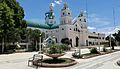
San Juan de la Maguana, Dominican Republic cathedral church.
-

Vallejuelo town entrance.
-

San Juan, Dominican Republic people.
-

Vallejuelo.


See also
 In Spanish: Provincia de San Juan (República Dominicana) para niños
