
Azua Province facts for kids
Quick facts for kids Azua |
||
| Province | ||
 Azua city hall
|
||
|
||
| Country | ||
|---|---|---|
| Development region | Valdesia (V) | |
| Capital | Azua de Compostela | |
| - elevation | 83 m (272 ft) | |
| - coordinates | 18°27′00″N 70°44′00″W / 18.45000°N 70.73333°W | |
| Lowest point | Caribbean Sea | |
| - elevation | 0 m (0 ft) | |
| Area | 2,682.5 km² (1,036 sq mi) | |
| Population | 298,246 (2014) | |
| Density | 111 /km² (287 /sq mi) | |
| Province since | 1844 | |
| Subdivisions | 10 municipalities 22 municipal districts |
|
| Congresspersons | 1 Senator 4 Deputies |
|
| Timezone | EST (UTC-4) | |
| Area code | 1-809 1-829 1-849 | |
| ISO 3166-2 | DO-02 | |

Azua is a Dominican province. It is located in the southern part of the country. The province stretches along the Caribbean coast. Its capital is Azua de Compostela.
After the Dominican independence from Haiti, Azua became one of the country's first five provinces in 1844. At that time, a large part of the southwestern region, including some areas now in Haiti, belonged to Azua.
Contents
What's in a Name?
The province gets its name from its capital city, Azua de Compostela. The word Azua was the original Taíno name for the area where the city was founded.
Where is Azua Located?
Azua province is surrounded by other provinces. To the northeast, it borders La Vega. To the east, you'll find San José de Ocoa and Peravia. The Caribbean Sea is to the south. To the west, it shares borders with Barahona and Baoruco. Finally, to the northwest, it meets the San Juan province.
 |
San Juan | La Vega province | |
|
| Baoruco | San José de Ocoa | |||
| Barahona | Caribbean Sea | Peravia |
A Look at Azua's History
People have lived in the Azua region for a very long time. Most early settlements were along the coast. When the Spanish arrived, only Taíno people lived here.
During colonial times, Azua de Compostela was a very important city on the Hispaniola island. This was because it had many factories that produced sugar. Hernán Cortés, a famous conquistador who explored Mexico, even lived here for a while.
After the Dominican Republic gained independence in 1844, many important battles took place here. These battles were between the Haitian and Dominican armies. Sadly, Azua de Compostela was burned down several times by the Haitian armies during these conflicts.
Over the years, new towns and districts were added to the province. Padre Las Casas became a municipality in 1942. Later, more municipalities were created, including Peralta (1978), Las Charcas (2001), Las Yayas de Viajama (2001), Estebanía (2001), Sabana Yegua (2003), Pueblo Viejo (2003), Tábara Arriba (2004), and Guayabal (2004).
The province also has many smaller areas called municipal districts. These were created at different times, starting in 2000.
How Many People Live in Azua?
In 2014, the last time a national count was done, there were about 298,246 people living in Azua province. About 165,703 of these people lived in towns and cities. This means the province has about 117.8 people per square kilometer.
Azua's population makes up about 3.16% of the total population of the Dominican Republic. It is the 23rd most populated province out of 31, plus the National District.
As of As of 2016[update], the estimated total population of the province is 219,856 people.
The largest city in the province is Azua de Compostela. It is the capital and had an urban population of 59,319 people in 2014.
Azua's Geography
The Azua province covers a total area of about 2,682.5 km2 (1,035.7 sq mi). This is about 5.6% of the total area of the Dominican Republic. It is the 5th largest province in the country. The capital city, Azua de Compostela, is about 83 m (272 ft) above sea level.
Most of Azua province is a very dry valley, known as the Azua Valley or Azua Plain. Because it's so dry, you'll often see cacti and other plants that thrive in dry areas.
The Cordillera Central, which is a large "Central mountain range", runs along the northern part of the province. To the east, the Sierra de Ocoa mountains separate Azua from the Peravia province. To the west, you'll find the Sierra Martín García and Sierra de Neiba mountain ranges.
The most important river in Azua is the Yaque del Sur. It has smaller rivers that flow into it, like Las Cuevas and Grande or Del Medio. Other important rivers include the Ocoa, Jura, and Vía. The Vía River even flows through the city of Azua de Compostela.
The main road in the province is the Carretera Sánchez (Sánchez National Road). It runs through the southern part of Azua, connecting Santo Domingo to the western part of the country, all the way to the border with Haiti. Other roads are smaller and connect the different towns and districts to this main road or to Azua de Compostela.
The Azua port is a small port located in the municipal district of Puerto Viejo.
Towns and Districts
The Azua province has 10 main towns, called municipalities. It also has 22 smaller areas called municipal districts (M.D.). Here is a list of the municipalities and their municipal districts:

| Municipality (code) | Municipal Districts (code) | Population (2010) |
Area (km2) |
Density | Altitude (m) |
|---|---|---|---|---|---|
| Azua de Compostela (020101) | 59,319 | 14.4 | 4,119.4 | 22 | |
| Barro Arriba (020102) | 5,262 | 35.8 | 147.0 | 172 | |
| Las Barías-La Estancia (020103) | 6,882 | 13.5 | 509.8 | 37 | |
| Los Jovillos (020104) | 5,962 | 46.9 | 127.1 | 44 | |
| Puerto Viejo (020105) | 2,194 | 56.1 | 39.1 | 6 | |
| Barreras (020106) | 2,364 | 97.8 | 24.2 | 129 | |
| Doña Emma Balaguer Vda. Vallejo (020107) | 2,759 | 8.2 | 336.5 | 43 | |
| Clavellina (020108) | 2,672 | 44.6 | 59.9 | 42 | |
| Las Lomas (020109) | 3,931 | 99.0 | 39.7 | 582 | |
| Azua de Compostela (020100) | 91,345 | 416.3 | 219.4 | ||
| Las Charcas (020201) | 8,191 | 187.6 | 43.7 | 137 | |
| Palmar de Ocoa (020202) | 3,052 | 59.4 | 51.4 | 10 | |
| Las Charcas (020200)) | 11,243 | 247.0 | 45.5 | ||
| Las Yayas de Viajama (020301) | 6,358 | 91.1 | 69.8 | 226 | |
| Villarpando (020302) | 7,160 | 154.8 | 46.3 | 357 | |
| Hato Nuevo Cortés (020303) | 4,102 | 185.2 | 22.1 | 237 | |
| Las Yayas de Viajama (020300) | 17,620 | 431.1 | 40.9 | ||
| Padre Las Casas (020401) | 8,487 | 128.0 | 66.3 | 1,030 | |
| Las Lagunas (020402) | 4,290 | 247.9 | 17.3 | 904 | |
| La Siembra (020403) | 1,538 | 37.6 | 40.9 | 907 | |
| Monte Bonito (020404) | 3,291 | 114.3 | 28.8 | 1,107 | |
| Los Fríos (020405) | 2,435 | 46.1 | 52.8 | 1,061 | |
| Padre Las Casas (020400) | 20,041 | 573.9 | 34.9 | ||
| Peralta (020501) | 15,257 | 129.4 | 117.9 | 1,184 | |
| Peralta (020500) | 15,257 | 129.4 | 117.9 | ||
| Sabana Yegua (020601) | 10,313 | 1.6 | 6,445.6 | 130 | |
| Proyecto 4 (020602) | 3,584 | 13.3 | 269.5 | 43 | |
| Ganadero (020603) | 2,240 | 3.2 | 700.0 | 52 | |
| Proyecto 2-C (020604) | 2,883 | 95.7 | 30.1 | 84 | |
| Sabana Yegua (020600) | 19,020 | 113.8 | 167.1 | ||
| Pueblo Viejo (020701) | 7,191 | 34.5 | 208.4 | 15 | |
| El Rosario (020702) | 4,044 | 13.6 | 297.4 | 13 | |
| Pueblo Viejo (020700) | 11,235 | 48.1 | 233.6 | ||
| Tábara Arriba (020801) | 3,066 | 17.0 | 180.4 | 316 | |
| Tábara Abajo (020802) | 5,423 | 165.0 | 32.9 | 131 | |
| Amiama Gómez (020803) | 2,765 | 15.4 | 179.5 | 373 | |
| Los Toros (020804) | 6,393 | 77.3 | 82.7 | 235 | |
| Tábara Arriba (020800) | 17,647 | 274.7 | 64.2 | ||
| Guayabal (020901) | 5,263 | 235.6 | 22.3 | 727 | |
| Guayabal (020900) | 5,263 | 235.6 | 22.3 | ||
| Estebanía (020911) | 5,640 | 212.7 | 26.5 | 81 | |
| Estebanía (02910) | 5,640 | 212.7 | 26.5 | ||
| Azua province (020000) | 214,311 | 2,682.5 | 79.9 | ||
What Does Azua Produce?
The main way people make a living in Azua province is through farming. In the valley areas, important crops include bananas, plantains, vegetables, and fruits like mango. Higher up in the northern mountains, coffee and beans are important products.
Fishing is also a key activity along the Caribbean coast.
Related Pages
Images for kids
-
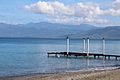
Palmar de Ocoa in Azua, Dominican Republic.

See also
 In Spanish: Provincia de Azua para niños
