
Santo Domingo facts for kids
Quick facts for kids
Santo Domingo
|
||
|---|---|---|
| Santo Domingo de Guzmán | ||

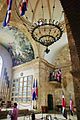
From top to bottom, from left to right: Panoramic Image of the City, Fortaleza Ozama, Parque a Colón, Autonomous University of Santo Domingo (UASD), Obelisk of George Washington Avenue (the Malecón), The National Palace of the Dominican Republic, Las Américas International Airport.
|
||
|
||
| Motto(s):
"Ciudad Primada de América"
("First City of America") |
||

Santo Domingo
Location in the Dominican Republic

Santo Domingo
Location in Caribbean

Santo Domingo
Location in North America
|
||
| Country | ||
| District | National District | |
| Founded | 5 August 1496 (530 years ago) | |
| Founder | Bartholomew Columbus | |
| Named for | Saint Dominic de Guzmán | |
| Area | ||
| • Total | 1,502 km2 (580 sq mi) | |
| • Metro | 2,770.00 km2 (1,069.50 sq mi) | |
| Elevation | 14 m (46 ft) | |
| Population
(November 2022)
|
||
| • Total | 1,029,110 | |
| • Density | 685.16/km2 (1,774.6/sq mi) | |
| • Urban | 1,029,110 | |
| • Metro | 4,274,651 | |
| Demonym(s) | Spanish: Capitaleño (fem. Capitaleña) | |
| Metro area GDP (PPP, constant 2015 values) | ||
| • Year | 2023 | |
| • Total | $73.7 billion | |
| • Per capita | $20,900 | |
| Time zone | UTC-04:00 (Atlantic Standard Time) | |
| • Summer (DST) | (Not Observed) | |
| Postal codes |
10100–10699 (Distrito Nacional)
|
|
| Area codes | 809, 829, 849 | |
| Website | ||
| Official name: Colonial City of Santo Domingo | ||
| Type: | Cultural | |
| Criteria: | ii, iv, vi | |
| Designated: | 1990 (14th session) | |
| Reference #: | 526 | |
| Region: | Latin America and the Caribbean | |
.svg)
Santo Domingo is the capital and largest city of the Dominican Republic. It is also the biggest city in the Caribbean region by population. As of 2022, the city and its immediate area, called the Distrito Nacional, had over 1 million people. When you include the wider metropolitan area, the total population is almost 3.8 million. The city is located in the Distrito Nacional, which is surrounded by Santo Domingo Province.
The Spanish founded Santo Domingo in 1496. It was first built on the east bank of the Ozama River. Later, in 1502, Nicolás de Ovando moved it to the west bank. This makes Santo Domingo the oldest continuously inhabited European settlement in the Americas. It was also the first place where the Spanish colonial government ruled in the New World. The city is home to the first university, cathedral, castle, monastery, and fortress in the Americas.
The historic part of the city, known as the Colonial Zone, is a World Heritage Site recognized by UNESCO. For a period between 1936 and 1961, Santo Domingo was called Ciudad Trujillo. This name was given by the Dominican Republic's leader, Rafael Trujillo, after himself. After he was no longer in power, the city went back to its original name.
Santo Domingo is the main center for culture, money, politics, business, and industry in the Dominican Republic. Most of the country's important businesses are located here. It also serves as the country's main seaport. Large ships can use the city's harbor at the mouth of the Ozama River, handling both passengers and cargo.
Contents
- History of Santo Domingo
- Geography and Climate
- Cityscape and Architecture
- Economy and Business
- Culture and Arts
- Media and Communication
- Parks and Green Spaces
- Education in Santo Domingo
- Transportation in Santo Domingo
- Sports in Santo Domingo
- International Connections
- Images for kids
- People from Santo Domingo
- See also
History of Santo Domingo

Before Christopher Columbus arrived in 1492, the island was home to the native Taíno people. They called the island Kiskeya or Ayiti. Columbus later named it Hispaniola. This island included the land that is now Republic of Haiti. At that time, the island had five main areas, each ruled by a chief called a cacique.
Santo Domingo became the oldest European city in the Americas. The Spanish first settled on the island in 1493. The city was officially founded on August 5, 1498, by Bartholomew Columbus. He first named it La Nueva Isabela, after an earlier settlement. In 1495, it was renamed "Santo Domingo" to honor Saint Dominic.
Santo Domingo became known as the "Gateway to the Caribbean." Many important expeditions started from here. These included trips that led to the colonization of Puerto Rico by Juan Ponce de León and Cuba by Diego Velázquez de Cuéllar. Also, Hernando Cortes's conquest of Mexico and Vasco Núñez de Balboa's discovery of the Pacific Ocean began from Santo Domingo.

In June 1502, a strong hurricane destroyed Santo Domingo. The new Governor, Nicolás de Ovando, had the city rebuilt. He chose a new location on the other side of the Ozama River. Today, you can still see the original layout of the city and parts of its old walls in the Colonial Zone. This area is a World Heritage Site by UNESCO.
In 1509, Diego Columbus, Christopher Columbus's son, arrived and took over as Viceroy. In 1521, the first major slave uprising in the Americas happened in Santo Domingo. Enslaved Africans started a revolt on Diego Columbus's sugar farm.
In 1586, a privateer named Sir Francis Drake captured the city. He held it for ransom. Drake's successful capture showed that Spain's control over Hispaniola was weakening. In 1697, the Treaty of Ryswick officially recognized France's control over the western part of the island, which is now Haiti.
From 1795 to 1822, Santo Domingo changed hands many times. It was given to France in 1795. Haitian rebels briefly captured it in 1801. France took it back in 1802. In 1805, Haiti tried to invade again but failed. Spain reclaimed the city in 1809. In 1821, Santo Domingo became the capital of an independent nation called the Republic of Spanish Haiti. However, Haiti annexed the nation just two months later.
On February 27, 1844, Santo Domingo became the capital of a free nation once more. This happened when the country gained independence from Haiti, led by Juan Pablo Duarte. The city was then fought over by different political groups for many years. The country also had to fight several battles with Haiti. These battles, like the Battle of 19 March and Battle of 30 March, are even mentioned in the national anthem. Dominican victories in these fights stopped the Haitian army from reaching Santo Domingo.
In 1861, Spain returned to control the country. This was part of a deal with the Dominican leader Pedro Santana. However, the Dominican Restoration War began in 1863. By 1865, Spain's Queen Isabella II pulled her soldiers out of the island.
Over the next decades, Santo Domingo and the Dominican Republic went through many changes in power. In 1916, the United States military was present in the Dominican Republic for the first time. This happened when different leaders were fighting for power in the city.

In 1930, Hurricane San Zenón hit the city. It caused huge damage and killed many people. After the city was rebuilt, it was officially named Ciudad Trujillo. This was because of the leader Rafael Trujillo, who ruled from 1930. After he was no longer in power in 1961, the city's name was changed back to Santo Domingo.
In 1962, Juan Bosch was elected president. He was removed from power seven months later. This led to a civil war in the capital. Francisco Caamaño led a group fighting to bring back democracy. This led to the second time the U.S. military was present in 1965. U.S. troops fought in the streets of Santo Domingo. The fighting ended on August 31, 1965.
The year 1992 marked 500 years since Christopher Columbus's voyages to the Americas. The Columbus Lighthouse was built in Santo Domingo to celebrate this event.
Geography and Climate

The Ozama River flows for about 148 kilometers before it reaches the Caribbean Sea. Santo Domingo's location on this river was very important for its economy and trade during colonial times. The country's busiest port is located on the Ozama River.
Santo Domingo's Weather
The temperature in Santo Domingo does not change much throughout the year. This is because of the tropical trade winds. These winds help to keep the heat and humidity from getting too extreme. Santo Domingo has a tropical rainforest or tropical monsoon climate. This means it gets a lot of rain, even in its driest months.
The coolest months are from December to March. During this time, days are warm with less humidity, and nights are cool. The hottest months are from July to September. Santo Domingo gets about 1445 millimeters of rain each year.
Like many cities in the Caribbean, Santo Domingo can be affected by hurricanes. Hurricane Georges caused a lot of damage in September 1998. The lowest temperature ever recorded was 11.0°C (51.8°F). The highest was 39.5°C (103.1°F).


| Climate data for Santo Domingo (1991–2020, extremes 1909–present) | |||||||||||||
|---|---|---|---|---|---|---|---|---|---|---|---|---|---|
| Month | Jan | Feb | Mar | Apr | May | Jun | Jul | Aug | Sep | Oct | Nov | Dec | Year |
| Record high °C (°F) | 34.4 (93.9) |
33.9 (93.0) |
36.0 (96.8) |
37.0 (98.6) |
39.5 (103.1) |
37.2 (99.0) |
37.8 (100.0) |
38.8 (101.8) |
36.7 (98.1) |
38.8 (101.8) |
35.0 (95.0) |
33.5 (92.3) |
39.5 (103.1) |
| Mean daily maximum °C (°F) | 30.0 (86.0) |
30.0 (86.0) |
30.5 (86.9) |
30.9 (87.6) |
31.3 (88.3) |
31.9 (89.4) |
32.2 (90.0) |
32.3 (90.1) |
32.4 (90.3) |
32.0 (89.6) |
31.3 (88.3) |
30.6 (87.1) |
31.3 (88.3) |
| Daily mean °C (°F) | 25.6 (78.1) |
25.6 (78.1) |
26.1 (79.0) |
26.7 (80.1) |
27.4 (81.3) |
28.0 (82.4) |
28.2 (82.8) |
28.3 (82.9) |
28.2 (82.8) |
27.9 (82.2) |
27.1 (80.8) |
26.2 (79.2) |
27.1 (80.8) |
| Mean daily minimum °C (°F) | 21.2 (70.2) |
21.2 (70.2) |
21.7 (71.1) |
22.5 (72.5) |
23.5 (74.3) |
24.2 (75.6) |
24.2 (75.6) |
24.3 (75.7) |
24.1 (75.4) |
23.8 (74.8) |
22.9 (73.2) |
21.9 (71.4) |
23.0 (73.4) |
| Record low °C (°F) | 11.0 (51.8) |
11.0 (51.8) |
13.3 (55.9) |
15.5 (59.9) |
16.5 (61.7) |
18.6 (65.5) |
18.2 (64.8) |
18.0 (64.4) |
18.0 (64.4) |
17.0 (62.6) |
17.0 (62.6) |
13.0 (55.4) |
11.0 (51.8) |
| Average precipitation mm (inches) | 68.1 (2.68) |
59.1 (2.33) |
54.1 (2.13) |
86.3 (3.40) |
151.3 (5.96) |
119.0 (4.69) |
156.7 (6.17) |
195.0 (7.68) |
191.7 (7.55) |
176.9 (6.96) |
147.5 (5.81) |
76.5 (3.01) |
1,482.2 (58.35) |
| Average rainy days (≥ 1.0 mm) | 8.3 | 6.8 | 7.0 | 6.5 | 10.5 | 9.3 | 10.8 | 11.5 | 12.1 | 12.5 | 10.7 | 9.1 | 115.1 |
| Average relative humidity (%) | 82.0 | 81.1 | 80.1 | 79.4 | 82.2 | 82.2 | 82.2 | 83.3 | 84.0 | 84.8 | 84.0 | 82.6 | 82.3 |
| Mean monthly sunshine hours | 239.7 | 229.6 | 253.4 | 248.8 | 233.9 | 232.3 | 225.9 | 231.6 | 219.9 | 230.7 | 227.5 | 224.1 | 2,797.4 |
| Source 1: NOAA, ONAMET (humidity, rain days, sunshine 1971–2000) | |||||||||||||
| Source 2: Diario Libre (May record high, and record lows for January and February), Meteo Climat (record highs and lows) | |||||||||||||
Cityscape and Architecture


Famous Buildings and Landmarks

Many of Santo Domingo's most famous landmarks are in the Colonial Zone. This area is a UNESCO World Heritage Site since 1990. The Colonial Zone is next to the Río Ozama. It has many buildings from the early 1500s. These include grand houses and churches that show the architectural style of the late Middle Ages. The Church and Convent of los Dominicos is the oldest Catholic building in the Americas that is still used. It was also the home of the first university in the Americas.
Some of the city's most important historical buildings are:
- The Catedral Santa María La Menor: This is the first cathedral built in the Americas.
- The Alcázar de Colón: This was the first castle in the Americas. It was once the home of Don Diego Colón, Christopher Columbus's son.
- The Monasterio de San Francisco: These are the ruins of the first monastery in the Americas.
- The Museo de las Casas Reales: This large complex includes the former Palace of the Governors. It also housed the building of the former Royal Audiencia of Santo Domingo.
- The Fortaleza Ozama: This is one of the remaining parts of the Walls of Santo Domingo. It is the oldest military building of European origin in the Americas.
- The Pantéon Nacional: This building used to be a Jesuit church. Now it holds the remains of many famous Dominicans.
- The Dominican Convent: This was the first convent in the Americas.
At the north end of Calle Las Damas, you will find the Plaza de España. It has been restored and expanded. It is next to Las Atarazanas, which used to be a naval yard and is now a museum. There are also many small shops and restaurants here. This area was the first European business center in the Americas. It is still a busy place today.
The Alcázar de Colón was once the palace of the Columbus family. It is now a museum. It shows furniture and decorations from that time. The building was first built in 1510. It was restored to its current look in 1952.
A large investment was made in the Port of the Ozama River. This port is next to the Colonial City. The goal is to make Santo Domingo a stop for luxury cruise ships. It will also include a private marina.
-
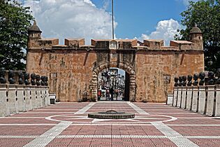
Puerta del Conde, built between 1543-1655, was the main entrance to the colonial fortified city of Santo Domingo
-
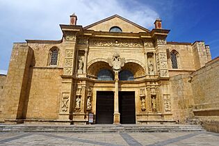
Gothic style Basilica Cathedral of Santa María la Menor, was the first cathedral built in the Americas
-
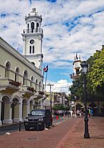
The City Hall of Santo Domingo, building built between 1504 to the early 19th century, but its tower was built in 1913
-
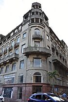
Edificio Baquero
-
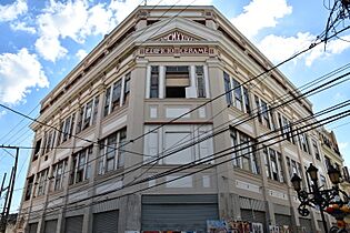
Edificio Cerame


City Neighborhoods

Santo Domingo is divided into areas called sectores, which are like small urban towns. The city mayor's office directly serves all these areas.
There are different types of sectores:
- Ciudad (city): These are the original, older parts of town. Many of them date back to colonial times.
- Ensanche (meaning "widening"): These are usually the more "modern" parts of the city.
- Villa (village): These are the areas on the edge of the old city and the current National District. They were originally separate villages.
Economy and Business

Santo Domingo is the main center for money and business in the Dominican Republic. Most of the country's wealth is here. It is also where the national government's main offices are located. Many national and international companies have their main or regional offices in Santo Domingo. The city attracts many global businesses like Ikea because of its location and stable economy.
The city's setup is good for most business operations. A key reason for the city's growth is its telecommunications system. Santo Domingo has a modern and wide-reaching system that was opened up to more competition in the late 1990s. This has brought in a lot of foreign investment. This has also attracted many call centers in recent years. Santo Domingo has great internet and phone systems. It also has many people who speak both Spanish and English.
You can see the city's economic growth in how many tall buildings are being built. There are many new residential towers, shopping malls, and elevated highways. The metro system is also expanding. All of this shows an increase in business activity.
Santo Domingo has a growing middle class. However, there are still areas with a lot of poverty. These areas are mostly in the northeast part of the city. Areas with a lot of new development include the Poligono Central. This area is known for its mixed buildings and busy nightlife.
Some other highly developed areas include Serralles, Naco, and Piantini. Most of the middle class lives in these areas. Bella Vista and La Esperilla are growing very fast with large new projects. Gazcue is an older area known for its buildings from the 1930s to the 1960s.
Culture and Arts
The performing arts are very important in Santo Domingo. The city has its own symphony orchestra. It also has a chamber orchestra, an opera company, and a ballet company. There is a folkloric dance company and a national theater. Many smaller groups also perform. The Plaza of Culture is a main center for these activities. However, concerts, ballet, and other shows happen all over the city. Casa de Teatro is a place where new artists, actors, and musicians meet. It hosts art and literature shows. It also offers classes in painting, drama, and dancing. They have monthly contests for poetry and short stories.


Santo Domingo has many museums. A lot of them are in the Colonial Zone. In the Colonial Zone, you can find:
- The Museum of Alcázar: This is in Diego Colon's palace.
- The Museum of the Casas Reales: This museum has items from the colonial period. It also has a collection of old weapons.
- The Naval Museum of the Atarazanas: This is in the old naval yards.
- The Museo de la Catedral.
- The Museo Memorial de la Resistencia Dominicana: This museum shows the fight for freedom during past governments.
- The Museo Duarte: This museum is about the hero of Dominican independence.
- The World of Ambar Museum.
Plaza de la Cultura also has the city's most important cultural places. These include the Teatro Nacional (National Theater) and various museums. The Palacio Nacional is where the President of the Dominican Republic works. The Palacio de Bellas Artes (Palace of Fine Arts) is a beautiful building. It is the permanent home of the country's National Symphony Orchestra.
Another attraction is the Centro Olímpico Juan Pablo Duarte. This is a sports complex in the center of Santo Domingo. It was used for the 2003 Pan American Games.
In the Plaza de la Cultura, you can find:
- The Museum of the Dominican Man: This museum has items from the ancient Taíno civilization.
- The National Museum of History and Geography.
- The Museum of Natural History.
- The Museum of Modern Art.
Other museums include the Museo Bellapart. This museum has a large private collection of Dominican paintings and sculptures from the 1800s and 1900s. The Museo Prehispanico has a major private collection of ancient Taíno art.
Media and Communication
Telecommunications in the Dominican Republic include radio, television, phones, and the Internet. Santo Domingo has 59 television stations. It has the most television signals in the country. Cable television channels are also available from companies like Aster and Cable TV Dominicana. In Santo Domingo, there are 100 different AM radio stations and 44 FM radio stations.
Parks and Green Spaces
The city has many parks, and some are quite large. Santo Domingo is surrounded by the Santo Domingo Greenbelt. Mirador Norte Park is in the north of the city. Mirador Sur Park is in the southwest. Mirador del Este is on the east bank of the Ozama River. It is where the Columbus Lighthouse is located. Independencia Park and Colón Park are in the Colonial Zone. The Zoo Parque Zoológico Nacional is home to many different plants and animals.

Other notable parks include:
- Parque Enriquillo
- Parque Independencia
- Parque Metropolitano Las Praderas
- El Malecón
- Jardín Botánico Nacional
- Parque Zoológico Nacional
- Barrio Chino de Santo Domingo (Chinatown)
- Parque Núñez de Cáceres
- Parque Iberoamérica
- Mirador Sur
Education in Santo Domingo
Santo Domingo has eighteen universities. This is the most of any city in the Dominican Republic. The Universidad Autónoma de Santo Domingo (UASD) was founded in 1538. It is the oldest university in the Americas. It is also the only public university in the city. Santo Domingo has the highest percentage of people with a college degree in the country.
Other universities include:
- Universidad Adventista Dominicana (UNAD)
- Universidad APEC (UNAPEC)
- Instituto Tecnológico de Santo Domingo (INTEC)
- Universidad del Caribe (UNICARIBE)
- Universidad Iberoamericana (UNIBE) (UNIBE)
- Universidad Católica Santo Domingo (UCSD)
- Universidad de la Tercera Edad (UTE)
- Universidad Tecnológica de Santiago (UTESA)
- Universidad Nacional Pedro Henríquez Ureña (UNPHU)
- Instituto de Ciencias Exactas (INCE)
- Universidad Organización y Método (O&M)
- Universidad Interamericana (UNICA)
- Universidad Eugenio María de Hostos (UNIREMOS)
- Universidad Francisco Henríquez y Carvajal (UFHEC)
- Universidad Instituto Cultural Domínico Americano (UNICDA)
- Pontificia Universidad Católica Madre y Maestra (PUCMM)
- Universidad de Psicologia Industrial Dominicana (UPID)
Transportation in Santo Domingo

Santo Domingo has a metro system with both underground and elevated tracks. It is the largest metro system in the Caribbean and Central America. The Santo Domingo Metro is part of a big plan to improve transportation in the city and the country. The first line was built to help with traffic on Máximo Gómez and Hermanas Mirabal Avenue. The second line opened in 2013. It helps with traffic along the Duarte-Kennedy-Centenario Corridor from west to east. As of 2013, the metro has these two lines. Four more lines are planned for the future, making a total of six. In 2012, over 30 million passengers used the Santo Domingo Metro. More than 300,000 people ride the 31-kilometer system every day.
In 2018, a 5-kilometer Teleférico de Santo Domingo (cable car) was opened. It helps people in the poorer areas in the east and north of the city. It also connects to the metro. More than 12,000 people use the cable car daily.
Santo Domingo has two airports. Aeropuerto Internacional La Isabela was built in the early 2000s. It is in the northern part of the city, close to the center. It mostly handles domestic and charter flights. The main international airport for the city is Santo Domingo Las Americas. It has flights to North, Central, and South America, and also to Europe.
The Port of Santo Domingo is on the Ozama River. Its location in the center of the Caribbean is great for planning ship routes. It has good support, road, and airport connections in the Santo Domingo area. This makes it easy to get to and from the port. The port is good for both starting and stopping cruise trips.
The port is being renovated as part of a big project. The goal is to connect the port area with the Colonial Zone. This will help make Santo Domingo a place for luxury cruise ships, yachts, and high-end tourism.
Santo Domingo is the end point for four of the five national highways. Highway DR-2 connects the city to the southwest. Highway DR-1 connects it to the northwest, including Santiago de los Caballeros. Highway DR-3 connects Santo Domingo directly to the east. This includes cities like San Pedro de Macorís and La Romana. It also connects to major tourist spots like Punta Cana and Bávaro. It connects to the Samaná Province in the northeast via the Samana Highway.
Within the city, common ways to get around are motoconchos (motorcycle taxis). There are also guaguas/voladoras (public buses) and carros públicos/conchos (shared taxis). The Santo Domingo Metro is the best quality public transport in the Caribbean and Central America. It has two lines that cross the city.
Main Avenues in Santo Domingo
Expreso John F. Kennedy: This major road crosses the National District from east to west in the north-central part. It has ten lanes in total, five on each side. The two middle lanes are express lanes to help traffic move faster. It also has several overpasses and tunnels.
Avenida 27 de Febrero: This is the main road that crosses the National District from east to west in the central part of Santo Domingo. It starts at the Juan Bosch bridge and goes across the whole city. It ends at the roundabout at the Plaza de la Bandera. This road has ten lanes in total, five on each side. The four middle lanes are express lanes. It also has special lanes for buses.
Avenida Simón Bolívar: This road goes from Independence Park to Winston Churchill Avenue. It has two lanes, both going one-way from east to west.
Avenida Independencia: This road goes from the intersection with Avenida Gregorio Luperón to Independence Park. It has four lanes (two in each direction) from Luperón to Avenida Italia. From Avenida Italia to Independence Park, it becomes one-way eastbound with two lanes.
Avenida George Washington: People often call this road "El Malecón." It is Santo Domingo's waterfront road, running along the Caribbean Sea. It goes from Palo Hincado Street to Abraham Lincoln Avenue. This road has four lanes (two in each direction). Along this road, you will find the city's most exclusive hotels and casinos. The Malecón Center, a tall building with businesses and homes, is also here. The Obelisk and Eugenio María de Hostos' Park are also on this road. The Santo Domingo Carnival parade takes place on this boulevard.
Avenida Winston Churchill: This road goes from Kennedy Avenue to Avenida 27 de Febrero. After that, it continues as Avenida Jimenez Moya to the Centro de los Heroes and then to the boardwalk. This road is known for its palm trees planted on the sidewalks. It has six lanes (three in each direction) and a large, tree-lined median. This median is known as Boulevard de la Churchill. The Boulevard of the Stars is also located here.
Avenida Abraham Lincoln: This road goes from Kennedy Avenue to the seawall. It has six lanes (three in each direction) and a median with palm trees, good for jogging. It passes through the city's main shopping and entertainment area.
Avenida José Ortega y Gasset: This road goes from Paseo de los Reyes Católicos Avenue to 27 de Febrero. It has four lanes, two in each direction. The Centro Olímpico Juan Pablo Duarte sports complex and the Hospital General de la Plaza de la Salud medical complex are along this road.
Avenida Tiradentes: This road goes from the jetty in the south, past the university Universidad Autónoma de Santo Domingo. It continues north past 27 de Febrero and John F. Kennedy avenues. It goes past the city's baseball stadium Estadio Quisqueya until it reaches the Parque Zoológico Nacional (National Zoo).
Avenida Gregorio Luperón: This road goes from Kennedy Avenue to Highway 30 May on the western edge of Santo Domingo. It has eight lanes, four in each direction, and a landscaped median. Attractions on this road include the Gallístico Center Herrera Industrial Zone and the Plaza de la Bandera.
Avenida Máximo Gómez y Báez: This is the city's main south-north road. It goes from the Malecón to the Presidente Peynado bridge. It has four lanes, two in each direction. Important buildings and places along this road include the National Cemetery and Plaza de la Cultura. Plaza de la Cultura has the National Theatre and the Palace of Fine Arts. There are also two universities (UNAPEC and UTESA) and the headquarters of the People's Bank.
Avenida Juan Pablo Duarte: This road goes from the intersection of Paseo and Martyrs of the Catholic Monarchs to Calle Padre Billini in the Colonial Zone. It has three lanes going north-south. It becomes one lane when it enters the Colonial Zone. This road is a main shopping area for people with lower incomes. It has department stores, restaurants, and shops with affordable goods and services. On "Duarte" (as it's called), you can find the New Market, Enriquillo Park, Duarte Commercial Square, and Santo Domingo's Chinatown.
Avenida Nicolás de Ovando y Cáceres: This road is in the northern part of Santo Domingo. It starts at the Cristo Rey roundabout and ends in the Simón Bolívar area. This road is known for its many businesses that sell car parts.
Sports in Santo Domingo
Baseball Teams

Baseball is the most popular sport in the Dominican Republic. It was brought to the country by the United States Marines. Santo Domingo is home to two of the six teams in the Dominican Professional Baseball League.
- Tigres del Licey: This team was founded in 1907. They have won 24 national championships since 1951. It is the oldest national team and has won 11 Caribbean Series titles.
- Leones del Escogido: This team was founded in 1921. They have won 16 national championships since 1951. They are the third team with the most championships. The team has also won 4 titles in the Caribbean Series.
Both of these teams play at the Estadio Quisqueya baseball stadium. In 2007, the stadium was rebuilt. This made it have more seats and improved the field.
Basketball Teams
Santo Domingo has a Basketball Tournament called Superior each year. Several teams from different areas and social clubs of the city take part.
Some of the teams in the tournament include:
- El Millón
- Rafael Barias
- Los Prados
- Mauricio Báez
- Mejoramiento social (BAMESO)
- Huellas del Siglo
- San Carlos
- San Lázaro
The city hosted the 2005 FIBA Americas Championship. This event was played at the Palacio de los Deportes Virgilio Travieso Soto.
Sports Clubs
- Club Arroyo Hondo
- Club Casa de España
- Club de Villa Francisca
- Club Los Prados
- Club Mauricio Báez
- Club Naco
- Club Paraíso
- Club San Carlos
- Club San Lázaro
- Club Santo Domingo
- Club Libanés Sirio Palestino
International Connections
Sister Cities
Santo Domingo is connected with other cities around the world as sister cities.
 Bogotá, Colombia
 Buenos Aires, Argentina
 Caracas, Venezuela
 Catbalogan, Philippines
 Curitiba, Brazil
 Guadalajara, Mexico
 Haifa, Israel
 Havana, Cuba
 Hunan province, China
 La Muela, Spain
- Madrid, Spain
- Manaus, Brazil (2009)
 Paris, France
- Pontevedra, Spain
 Providence, Rhode Island, United States
- Rosario, Argentina
 Quito, Ecuador
- Santa Cruz de Tenerife, Spain
- Santiago, Philippines
 Taipei, Taiwan
 Seoul, South Korea
- Busan, South Korea
Santo Domingo also has four sister cities chosen by Sister Cities International:
- St. Augustine, Florida, United States
- Miami-Dade County, Florida, United States
- Miami, United States
- New York, United States
Images for kids
-
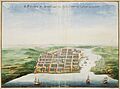
Santo Domingo city as depicted by Johannes Vingboons in 1665. Nationaal Archief.
-
Edificio Diez
-
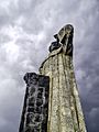
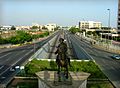
Statue of Antonio de Montesinos
-
John F. Kennedy Avenue, Santo Domingo
-
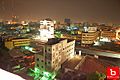
Santo Domingo at night
-
Anacaona Avenue in Santo Domingo. Mirador del Sur park
-
Church of Nuestra Señora de Las Mercedes
-
National pantheon
-
Calle Arzobispo Meriño


People from Santo Domingo
- JM Balbuena (born 1984), an author, filmmaker, and business person.
- Famous Dominican singer Juan Luis Guerra-Seijas was born on June 7, 1957, in Santo Domingo.
See also
 In Spanish: Santo Domingo para niños
