
Ozama River facts for kids
Quick facts for kids Ozama |
|
| River | |
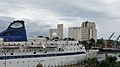
 The River Ozama in Santo Domingo
|
|
| Country | Dominican Republic |
|---|---|
| Provinces | Monte Plata, Santo Domingo |
| Municipalities | Peralvillo, Monte Plata, Santo Domingo Este, Santo Domingo Norte, Distrito Nacional |
| Tributaries | |
| - left | Mijo, Boyá, Yabacao |
| - right | Río Verde, Yamasá, Guanuma, La Isabela River |
| Source | |
| - location | Loma Siete Cabezas, Sierra de Yamasá, Dominican Republic |
| - elevation | 856 m (2,808 ft) |
| Mouth | Caribbean Sea |
| - location | Santo Domingo, Dominican Republic |
| - elevation | 0 m (0 ft) |
| - coordinates | 18°28′N 69°53′W / 18.467°N 69.883°W |
| Length | 148 km (92 mi) |
| Basin | 2,685 km² (1,037 sq mi) |
The Ozama River is an important river in the Dominican Republic. It flows through the eastern part of the "Caribbean Coastal Plain." This river is 148 km long, making it the fourth longest river in the country.
Its watershed (the area of land where all the water drains into the river) covers 2,685 square kilometers. This is also the fourth largest watershed in the Dominican Republic. Because there's a lot of rainfall in its watershed all year round, the Ozama River always has a good flow of water.
Contents
What's in a Name?
The name "Ozama" comes from the Taíno people, who were the original inhabitants of the island. An early writer, Bartolomé de Las Casas, used to spell it Hozama.
In his time, the letter "H" was pronounced like the "H" in English words such as "house." Over time, the "H" disappeared, and the name became "Ozama" as we know it today.
Where the River Flows
The Ozama River starts in a mountain called Loma Siete Cabezas, which means "Seven Heads Mountain." This mountain is the highest point in the Sierra de Yamasá mountain range.
First, the river flows east through the Monte Plata Province. Then, it slowly turns southeast. For a while, it forms the border between the Santo Domingo Province and the Monte Plata Province.
Near the town of San Luis, another river called the Yabacao joins the Ozama. After this, the Ozama turns southwest. Finally, when it reaches the big city of Santo Domingo, the river flows south and empties into the Caribbean Sea.
The most important rivers that flow into the Ozama (called tributaries) are the Yabacao, Isabela, and Savita (or Sabita) rivers.
Cities Along the Ozama
The biggest city located on the banks of the Ozama River is the Greater Santo Domingo. This area includes the main city of Santo Domingo and parts of Santo Domingo Este and Santo Domingo Norte.
The river actually divides the old city of Santo Domingo into three parts. Before 2001, all three parts were considered one city. Now, only the western part is called Santo Domingo. The eastern part is its own city, Santo Domingo Este, and the northern part is Santo Domingo Norte.
River Environment and Use
The Ozama River flows through an area that gets a lot of rain. This means its water isn't usually needed for irrigation (watering crops). However, the water often carries a lot of solid materials, so it's not used for homes.
Near the mouth of the river, water from the Caribbean Sea flows several km upstream. This happens because the riverbed (the bottom of the river) is lower than the sea level. This mix of fresh and salty water creates a special environment.
In the past, there were many mangroves (special plants that can grow in salty water) along the riverbanks. You can still find some mangroves near La Victoria, close to where the river meets the sea.
Sadly, the water quality of the Ozama River has been greatly affected. Factories, ships, and the large number of people living near the river's mouth have caused a lot of pollution.
The river is not deep enough for very large ships, except right near its mouth. In the past, when the country was a Spanish colony, and even after it became independent, people used flat boats to travel along the river and move goods.
The Ozama in History
The city of Santo Domingo was first built in the 16th century on the left side of the river's mouth. But it was soon moved to the right side and became the capital city of the Spanish colony.
Sugarcane was a very important crop grown in the lands around the Ozama River and its tributary, the Isabela. The river was used to transport the sugar to the port of Santo Domingo.
In the 19th and 20th centuries, sugarcane continued to be the most important crop near the Ozama River. Raising Cattle was also important because there was plenty of grass for them to eat.
For the second half of the 20th century, Santo Domingo's port, located near the mouth of the Ozama River, became the most important port in the country. Today, this port is mainly used for tourist ships.
The Ozama in Art
The Ozama River has often appeared in art, especially in poetry. It has become a symbol of the Dominican Republic itself. Many poets wrote poems about the river when they were living outside the country for political reasons. They used the river to represent their longing to return home.
For example, José Joaquín Puello, a Dominican poet from the 19th century, wrote several poems where the Ozama River symbolized the country. Two of his famous poems are Ecos del destierro ("Distant sounds from the exile") and La vuelta al hogar ("Back to home").
Images for kids
-
Port in Ozama river.

See also
 In Spanish: Río Ozama para niños
