
Santo Domingo Province facts for kids
Santo Domingo is a large and important province in the Dominican Republic. It's located in the southern part of the country, right on the beautiful Caribbean coast. The capital city of this province is Santo Domingo Este. It's a busy and exciting place with lots of people and activities!
Quick facts for kids Santo Domingo |
||
| Province | ||
 Faro a Colón, Santo Domingo Este
|
||
|
||
| Country | ||
|---|---|---|
| Development region | Ozama (X) | |
| Capital | Santo Domingo Este | |
| - elevation | 35 m (115 ft) | |
| - coordinates | 18°29′36″N 69°52′00″W / 18.49333°N 69.86667°W | |
| Lowest point | ||
| - location | Caribbean Sea | |
| - elevation | 0 m (0 ft) | |
| Area | 1,302.2 km² (503 sq mi) | |
| Population | 3,263,053 (2014) | |
| Density | 2,506 /km² (6,491 /sq mi) | |
| Province since | 2001 | |
| Subdivisions | 7 municipalities 8 municipal districts |
|
| Congresspersons | 1 Senator 36 Deputies |
|
| Timezone | EST (UTC-4) | |
| Area code | 1-809 1-829 1-849 | |
| ISO 3166-2 | DO-32 | |

Contents
What's in a Name? The Story of Santo Domingo
The Santo Domingo province gets its name from the famous city of Santo Domingo. This city has always been the most important capital of the entire country.
A Look Back: History of the Province
This province is quite new! It was officially created on October 16, 2001. Before that, most of its land was part of the Distrito Nacional, which means "National District." It was like a special area around the capital city.
When it became a province, it started with four main areas called municipalities: Santo Domingo Este, Santo Domingo Oeste, Santo Domingo Norte, and Boca Chica. Later, more municipalities were added: San Antonio de Guerra in 2004, and Pedro Brand and Los Alcarrizos in 2005.
The province also has smaller areas called municipal districts. These were added over time:
- In 2001: La Victoria
- In 2004: Hato Viejo, San Luis, and La Caleta
- In 2005: Palmarejo-Villa Linda, Pantoja, La Guáyiga, and La Cuaba
Where is Santo Domingo Province Located?
The Santo Domingo province is surrounded by other interesting places. To the north, it borders the Monte Plata province. To the east, you'll find the San Pedro de Macorís province. The beautiful Caribbean Sea is to its south, and the San Cristóbal province is to its west.
 |
Monte Plata | |
||
| San Cristóbal | San Pedro de Macorís | |||
| Caribbean Sea |
People and Population
Santo Domingo is the most populated province in the Dominican Republic! In the last national count (2014), there were about 3,263,053 people living here. A huge number of these people, about 2,084,651, live in the towns and cities.
This means that Santo Domingo province has the largest population out of all 31 provinces and the National District. As of 2016, it's estimated that over 2.7 million people live in the province.
The biggest city area in the province is Santo Domingo Este. It's the capital and had over 851,853 people living there in 2014.
Geography and Landscape
The Santo Domingo province covers a total area of about 1,302.2 square kilometers (502.8 square miles). This makes it the 16th largest province in the Dominican Republic.
The capital city, Santo Domingo Este, is about 35 meters (115 feet) above sea level.
Most of the Santo Domingo province is part of a large flat area called the "Caribbean Coastal Plain." This means there aren't many mountains here, just some small hills.
Two important rivers flow through or near the province. The Haina River forms the western border of the province. The Ozama River and its smaller branch, La Isabela, separate the province from the Distrito Nacional.
Climate: What's the Weather Like?
The climate in Santo Domingo province is tropical. This means it's usually warm or hot for most of the year, perfect for enjoying the coast!
How the Province is Organized: Municipalities
The Santo Domingo province is divided into 7 main areas called municipalities. Within these municipalities, there are also 8 smaller areas known as municipal districts.

Economy: How People Make a Living
Santo Domingo province is a very important place for the country's economy. It has a lot of industries and businesses. Many companies operate here, making it a hub for economic activity.
Tourism is also a big part of the economy, especially in Boca Chica. This area has a beautiful beach with soft white sand, which attracts many visitors.
Images for kids
-
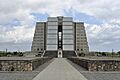
Faro a Colón, Santo Domingo Este
-
Coat of Arms of Santo Domingo Province
-
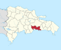
Location of the Santo Domingo Province
-
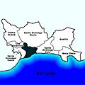
Municipalities of Santo Domingo Province

See also
 In Spanish: Provincia de Santo Domingo para niños
