
San Cristóbal Province facts for kids
Quick facts for kids San Cristóbal |
||
| Province | ||
|
||
| Country | ||
|---|---|---|
| Development region | Valdesia (V) | |
| Capital | San Cristóbal | |
| - elevation | 49 m (161 ft) | |
| - coordinates | 18°25′12″N 70°06′36″W / 18.42000°N 70.11000°W | |
| Lowest point | Caribbean Sea | |
| - elevation | 0 m (0 ft) | |
| Area | 1,240.6 km² (479 sq mi) | |
| Population | 640,066 (2014) | |
| Density | 516 /km² (1,336 /sq mi) | |
| Province since | 1932 | |
| Subdivisions | 8 municipalities 6 municipal districts |
|
| Congresspersons | 1 Senator 11 Deputies |
|
| Timezone | EST (UTC-4) | |
| Area code | 1-809 1-829 1-849 | |
| ISO 3166-2 | DO-21 | |

San Cristóbal is a province in the Dominican Republic. It is located on the country's south coast. The capital city of the province is also called San Cristóbal.
Contents
About the Name
The province is named after its capital city, San Cristóbal. However, when it was first created, it had a different name: Trujillo. This name honored Rafael Trujillo, a former leader of the country who was born in the city. Later, the name was changed back to San Cristóbal.
History of San Cristóbal Province
The San Cristóbal province was formed in 1932. It included several towns like San Cristóbal, Baní, and Monte Plata. San Cristóbal city became its capital.
In 1934, the province's name was changed to Provincia Trujillo. It included many of the same towns. Then, in 1961, the name was changed again to its current name, Provincia San Cristóbal.
Over the years, some parts of San Cristóbal province became new provinces. For example, when Monte Plata province was created in 1982, San Cristóbal province became smaller. New towns and areas have also joined the province over time.
Where is San Cristóbal Located?
San Cristóbal province is in the southern part of the Dominican Republic.
- To the north, it borders the Monseñor Nouel province.
- To the northeast, it borders the Monte Plata province.
- To the east, it borders the Santo Domingo province.
- To the west, it borders the Peravia and San José de Ocoa provinces.
- The Caribbean Sea is to the south of the province.
Population of San Cristóbal
According to the last national count in 2014, about 640,066 people lived in San Cristóbal province. A large number of these people, 295,539, lived in towns and cities.
The province has many people living in it. It is the 4th most populated province in the Dominican Republic. As of As of 2016[update], the estimated total population was 611,677 people.
The biggest city in the province is San Cristóbal. In 2014, about 138,455 people lived in the city area.
Geography and Rivers
San Cristóbal province covers an area of about 1,240.6 square kilometers (479 square miles). This makes it the 19th largest province in the Dominican Republic.
The capital city, San Cristóbal, is about 49 meters (161 feet) above sea level.
Important rivers in the province include:
- The Haina River, which forms part of the province's eastern border.
- The Nigua River, which flows through the capital city.
- The Nizao River, which forms part of the province's western border.
Towns and Districts
The province of San Cristóbal is divided into 8 main towns, called municipalities. It also has 6 smaller areas called municipal districts.

| Municipality | Population (2010) |
Area (km2) |
Altitude (m) |
|---|---|---|---|
| San Cristóbal | 232,769 | 212.6 | 49 |
| Sabana Grande de Palenque | 15,466 | 30.0 | 19 |
| Bajos de Haina | 124,193 | 39.7 | 2 |
| Cambita Garabitos | 31,057 | 172.8 | 182 |
| Villa Altagracia | 84,312 | 426.2 | 198 |
| Yaguate | 42,325 | 122.3 | 54 |
| San Gregorio de Nigua | 30,268 | 51.1 | 8 |
| Los Cacaos | 9,540 | 185.9 | 555 |
Images for kids
-
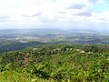
Fuerte Resoli in San Cristobal, Dominican Republic
-
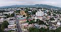
City of San Cristobal.
-
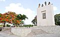
San Cristobal, Dominican Republic park.


See also
 In Spanish: Provincia de San Cristóbal para niños
