
San José de Ocoa Province facts for kids
Quick facts for kids San José de Ocoa |
|
| Province | |
| Country | |
|---|---|
| Development region | Valdesia (V) |
| Capital | San José de Ocoa |
| - elevation | 513 m (1,683 ft) |
| - coordinates | 18°33′N 70°30′W / 18.550°N 70.500°W |
| Area | 853.4 km² (329 sq mi) |
| Population | 97,640 (2014) |
| Density | 114 /km² (295 /sq mi) |
| Province since | 2000 |
| Subdivisions | 3 municipalities 4 municipal districts |
| Congresspersons | 1 Senator 2 Deputies |
| Timezone | EST (UTC-4) |
| Area code | 1-809 1-829 1-849 |
| ISO 3166-2 | DO-31 |
San José de Ocoa is a Dominican province located on the southern side of the Cordillera Central (which means "Central mountain range"). Its capital city is also called San José de Ocoa.
This province was officially created on September 6, 2000, and began operating on January 1, 2001. Before becoming a province, it was a municipality within the Peravia province.
Contents
What's in a Name?
The province gets its name from its capital city, San José de Ocoa. The word Ocoa comes from the Taíno language, which was spoken by the native people of the island. It means "a place with many mountains."
A Look Back: History of San José de Ocoa
The region of San José de Ocoa has a long and interesting history. One of the first people to write about this area was Bartolomé de Las Casas. He mentioned a place called Maniey, which is now known as Maniel. In the Taíno language, Maniey or Maniel meant "a place where there are peanuts."
For a long time, the high mountains of this region were mostly visited by monteros. These were men who hunted wild cows and pigs. Later, some maroons came to live here. Maroons were enslaved people who had escaped and built their own communities.
Early Settlements
The first known settlement by maroons in this region began in the early 1500s. It was called Maniel Viejo de Ocoa. This settlement lasted until around 1666 or 1667. Many people in the settlement became sick and died from diseases like smallpox and measles. There were also military actions to capture the maroons.
A second settlement was founded around 1802. It was known as Maniel de los Lorenzos ("Lorenzos' Maniel"). It was named after the Lorenzo family, who were its founders. This settlement was located at El Canal, which is north of the city of San José de Ocoa.
Soon after, families from Baní, a city to the south, started moving into the region. They built their homes in what is now the city of San José de Ocoa.
Battles for Independence
During the Dominican War of Independence in 1844, two important battles took place in this region: the battles of El Memiso and El Pinar. Dominican soldiers won both of these battles. This victory stopped the Haitian soldiers from reaching Santo Domingo, the capital, and forced them to return to Haiti.
Becoming a Province
In December 1858, San José de Ocoa became a municipality within the old province of Santo Domingo. Later, in 1895, it became a municipality of the Azua province. When the Peravia province was created, San José de Ocoa became one of its municipalities.
Finally, on September 6, 2000, San José de Ocoa was made a new province. It was formed from the northern part of the Peravia province. It included the municipalities of San José de Ocoa, Rancho Arriba, and Sabana Larga, along with the municipal district of La Ciénaga.
In the following years, more municipal districts were added: Nizao-Las Auyamas and El Pinar in 2004, and El Naranjal in 2006.
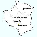
Where is San José de Ocoa Located?
San José de Ocoa province is surrounded by other provinces.
- To the north, it borders the Monseñor Nouel and La Vega provinces.
- To the east, it borders San Cristóbal.
- To the south, it borders the Peravia province.
- To the west, it borders Azua province.
 |
La Vega | Monseñor Nouel | |
|
| Azua | San Cristóbal | |||
| Peravia |
People and Population
According to the last national census in 2014, there were 97,640 people living in San José de Ocoa province. About 37,466 of these people (which is 38.4% of the total) live in towns and cities.
The population density of the province was 114.4 people per square kilometer. This province is the 29th most populated province in the Dominican Republic.
As of As of 2016[update], the estimated total population of the province is 56,565 people.
The largest city in the province is San José de Ocoa, which is also its capital. In 2014, its urban population was 22,383 inhabitants.
Geography and Rivers
The San José de Ocoa province covers a total area of 853.4 km2 (329.5 sq mi). This makes it the 26th largest province in the Dominican Republic.
The capital city, San José de Ocoa, is located at an altitude of 513 m (1,683 ft) above sea level.
The most important river in the province is the Ocoa river. It flows through the province from north to south.
How the Province is Divided: Municipalities
The province of San José de Ocoa is divided into 3 main municipalities and 4 smaller municipal districts.

| Municipality (code) |
Municipal Districts (code) | Population (2010) |
Area (km2) |
Density | Altitude (m) |
|---|---|---|---|---|---|
| San José de Ocoa (310101) | 25,710 | 82.4 | 312.0 | 513 | |
| La Ciénaga (310102) | 4,128 | 126.5 | 32.6 | 739 | |
| Nizao - Las Auyamas (310103) | 2,791 | 92.7 | 30.1 | 589 | |
| El Pinar (310104) | 3,736 | 154.7 | 24.1 | 638 | |
| El Naranjal (310105) | 3,086 | 28.5 | 108.3 | 661 | |
| San José de Ocoa (310100) | 39,451 | 484.8 | 81.4 | ||
| Sabana Larga (310201) | 9,794 | 163.6 | 59.9 | 623 | |
| Sabana Larga (310200) | 9,794 | 163.6 | 59.9 | ||
| Rancho Arriba (310301) | 10,299 | 205.0 | 50.2 | 687 | |
| Rancho Arriba (310300) | 10,299 | 205.0 | 50.2 | ||
| San José de Ocoa (310000) | 97,640 | 853.4 | 114.4 | ||
Economy: What Do People Do Here?
The main way people make a living in San José de Ocoa province is through farming. The most important crops grown here are coffee, beans, and potatoes. Farmers also grow other vegetables like cabbage and carrots. You can also find tropical fruits such as avocado and mango growing in the area.
Images for kids
-
Municipalities of the Province.

See also
 In Spanish: Provincia de San José de Ocoa para niños
