
Santiago de los Caballeros facts for kids
Quick facts for kids
Santiago
|
||
|---|---|---|
|
City
|
||
| Santiago de los Caballeros | ||
|
|
||
|
||
| Nickname(s):
Ciudad Corazón
|
||
| Motto(s):
"La Ciudad Corazón", "Primer Santiago de América"
("The Heartland City", "First Santiago of the Americas") |
||

Santiago
Location in the Dominican Republic
|
||
| Country | ||
| Province | Santiago | |
| Municipality | Santiago de los Caballeros | |
| Founded | 1495 | |
| Area | ||
| • Total | 524.01 km2 (202.32 sq mi) | |
| Elevation | 175 m (574 ft) | |
| Population
(2022 census)
|
||
| • Total | 1,074,684 | |
| • Density | 2,050.885/km2 (5,311.77/sq mi) | |
| • Demonym | Spanish: Santiaguero; Santiagueño | |
| GDP (PPP, constant 2015 values) | ||
| • Year | 2023 | |
| • Total | $16.0 billion | |
| • Per capita | $23,200 | |
| Time zone | UTC-4 (Atlantic Standard Time) | |
| Climate | Am | |
| Municipal districts | 5 | |
| Website | [1] | |


Santiago de los Caballeros (which means Saint James of the Knights), often called just Santiago, is the second-largest city in the Dominican Republic. It's also the fourth-largest city in the Caribbean by population. Santiago is the capital of Santiago Province. It is the biggest city in the Cibao region of the country.
Santiago is special because it's the largest Caribbean city that isn't a capital city. It's also the biggest major city in the Caribbean islands that isn't on the coast. In 2022, about 1,074,684 people lived there. Santiago is about 155 km (96 mi) northwest of the capital city, Santo Domingo. It sits at an average height of 178 m (584 ft) above sea level.
The city was started in 1495 when Europeans first settled in the New World. This makes it the "first Santiago of the Americas." Today, Santiago is a major center for culture, politics, industry, and money in the Dominican Republic. Because it's in the very fertile Cibao Valley, it has strong farming. It's also a top exporter of rum, textiles, and cigars. Santiago is lovingly known as "La Ciudad Corazón," which means "the Heartland City."
Santiago de los Caballeros has always been an important city in the Dominican War of Independence. The city's name, "Saint James of the Knights," comes from the Hidalgos de la Isabela. These were a group of knights who moved from La Isabela to live in Santiago. Sometimes, people call the city Santiago de los 30 Caballeros, meaning "Saint James of the 30 Knights."
Contents
- History of Santiago
- Santiago's Geography and Climate
- Santiago's Economy and Growth
- Arts and Culture in Santiago
- Sports in Santiago
- Education in Santiago
- Transportation in Santiago
- Interesting Sites in Santiago
- Recreation and Fun in Santiago
- Famous People from Santiago de los Caballeros
- Sister Cities of Santiago
- Images for kids
- See also
History of Santiago
The city's name, "Saint James of the Knights," honors the Hidalgos de la Isabela. These knights came from La Isabela to settle in Santiago. The first settlement was in San Francisco de Jacagua, founded in 1495. But an earthquake destroyed it, so the city moved to its current spot in 1506.

In 1508, King Ferdinand gave Santiago the Royal Privilege of Concession de Armas. This included a special symbol on its shield. Another earthquake hit the city on December 2, 1562, causing great damage. The people who survived moved to land near the Yaque del Norte River. This is where the city stands today.
French rule during the Peace of Basel (1795) left its mark on Santiago. But the city was given back to Spain in 1814 by the Peace of Paris. In the 1800s, Santiago began to grow with modern city planning. The Palace Hall, built from 1892 to 1895 by a Belgian architect named Louis Bogaert, shows European design. Many beautiful homes in European styles were built in the late 1800s. These buildings form the historic center of Santiago.
Santiago's Geography and Climate

Santiago de los Caballeros is located in the middle of the Cibao Valley. This area is known for being one of the most fertile lands on the island. The city sits on hilly ground in the Central Region of the Dominican Republic. The Yaque del Norte River flows through Santiago. The city is nestled between two major mountain ranges: the Cordillera Central and the Cordillera Septentrional. These ranges help form the Cibao Valley.
City Districts
Santiago is divided into several areas, including its main city core and districts:
| Division | Status | Area in km² | Population (2022) | Population Density |
|---|---|---|---|---|
| Hato del Yaque | District | 37.96 | 34,458 | 907.6 |
| La Canela | District | 93.49 | 20,214 | 216.2 |
| Pedro García | District | 52.51 | 3,361 | 64.0 |
| San Francisco de Jacagua | District | 82.74 | 47,223 | 570.7 |
| Santiago | Municipal Core | 148.3 | 561,005 | 3,783 |
| Santiago Oeste | District | 16.67 | 105,487 | 6,329 |
Santiago's Climate
Santiago has a tropical monsoon climate (Am). This means it's generally warm and humid. The temperature doesn't change much throughout the year. This is because of the tropical trade winds, which help keep the weather mild. December and January are the coolest months, while July and August are the warmest.
Because Santiago is in the Caribbean and at 183 m (600 ft) above sea level, it often has cloudy conditions. The whole country can be affected by Atlantic hurricanes. However, Santiago is more protected from hurricanes. Its location in the Cibao Valley helps shield it.
| Climate data for Santiago de los Caballeros (1991–2020) | |||||||||||||
|---|---|---|---|---|---|---|---|---|---|---|---|---|---|
| Month | Jan | Feb | Mar | Apr | May | Jun | Jul | Aug | Sep | Oct | Nov | Dec | Year |
| Mean daily maximum °C (°F) | 28.9 (84.0) |
29.7 (85.5) |
30.7 (87.3) |
31.3 (88.3) |
31.9 (89.4) |
33.1 (91.6) |
33.2 (91.8) |
33.5 (92.3) |
33.3 (91.9) |
32.6 (90.7) |
30.6 (87.1) |
29.3 (84.7) |
31.5 (88.7) |
| Daily mean °C (°F) | 23.8 (74.8) |
24.4 (75.9) |
25.1 (77.2) |
26.0 (78.8) |
26.9 (80.4) |
27.9 (82.2) |
28.1 (82.6) |
28.2 (82.8) |
27.9 (82.2) |
27.3 (81.1) |
25.7 (78.3) |
24.3 (75.7) |
26.3 (79.3) |
| Mean daily minimum °C (°F) | 18.8 (65.8) |
19.1 (66.4) |
19.5 (67.1) |
20.7 (69.3) |
21.8 (71.2) |
22.8 (73.0) |
22.9 (73.2) |
22.9 (73.2) |
22.4 (72.3) |
22.0 (71.6) |
20.7 (69.3) |
19.3 (66.7) |
21.1 (70.0) |
| Average precipitation mm (inches) | 69.4 (2.73) |
42.1 (1.66) |
73.5 (2.89) |
121.2 (4.77) |
140.4 (5.53) |
67.4 (2.65) |
73.4 (2.89) |
76.8 (3.02) |
94.7 (3.73) |
118.2 (4.65) |
107.7 (4.24) |
81.4 (3.20) |
1,066.1 (41.97) |
| Source: NOAA | |||||||||||||
| Climate data for Santiago de los Caballeros (1971-2000) | |||||||||||||
|---|---|---|---|---|---|---|---|---|---|---|---|---|---|
| Month | Jan | Feb | Mar | Apr | May | Jun | Jul | Aug | Sep | Oct | Nov | Dec | Year |
| Record high °C (°F) | 34.4 (93.9) |
34.7 (94.5) |
35.8 (96.4) |
36.0 (96.8) |
36.0 (96.8) |
36.7 (98.1) |
36.6 (97.9) |
38.2 (100.8) |
37.6 (99.7) |
36.5 (97.7) |
39.8 (103.6) |
34.7 (94.5) |
39.8 (103.6) |
| Mean daily maximum °C (°F) | 28.9 (84.0) |
29.4 (84.9) |
30.4 (86.7) |
31.1 (88.0) |
31.9 (89.4) |
32.9 (91.2) |
33.1 (91.6) |
33.2 (91.8) |
33.1 (91.6) |
32.4 (90.3) |
30.5 (86.9) |
28.9 (84.0) |
31.3 (88.4) |
| Daily mean °C (°F) | 23.7 (74.7) |
24.0 (75.2) |
24.8 (76.6) |
25.6 (78.1) |
26.6 (79.9) |
27.6 (81.7) |
27.8 (82.0) |
27.8 (82.0) |
27.6 (81.7) |
27.0 (80.6) |
25.5 (77.9) |
23.9 (75.0) |
26.0 (78.8) |
| Mean daily minimum °C (°F) | 18.5 (65.3) |
18.7 (65.7) |
19.3 (66.7) |
20.2 (68.4) |
21.4 (70.5) |
22.4 (72.3) |
22.4 (72.3) |
22.4 (72.3) |
22.0 (71.6) |
21.6 (70.9) |
20.5 (68.9) |
19.0 (66.2) |
20.7 (69.3) |
| Record low °C (°F) | 11.2 (52.2) |
12.2 (54.0) |
12.5 (54.5) |
12.7 (54.9) |
16.3 (61.3) |
18.5 (65.3) |
17.0 (62.6) |
17.6 (63.7) |
18.6 (65.5) |
17.5 (63.5) |
15.0 (59.0) |
12.1 (53.8) |
11.2 (52.2) |
| Average rainfall mm (inches) | 55.0 (2.17) |
42.3 (1.67) |
61.9 (2.44) |
109.3 (4.30) |
133.1 (5.24) |
63.7 (2.51) |
48.1 (1.89) |
71.9 (2.83) |
85.3 (3.36) |
112.4 (4.43) |
94.4 (3.72) |
68.2 (2.69) |
945.6 (37.25) |
| Average rainy days (≥ 1.0 mm) | 8.0 | 6.5 | 6.0 | 8.0 | 9.6 | 5.3 | 6.8 | 7.4 | 7.9 | 9.3 | 9.6 | 9.6 | 94 |
| Average relative humidity (%) | 77.2 | 75.1 | 71.6 | 71.5 | 73.5 | 71.0 | 70.5 | 71.5 | 73.4 | 75.4 | 78.4 | 78.5 | 74.0 |
| Mean monthly sunshine hours | 224.1 | 202.2 | 245.2 | 236.9 | 242.7 | 245.9 | 255.1 | 262.8 | 234.5 | 235.4 | 212.2 | 205.1 | 2,802.1 |
| Source: ONAMET | |||||||||||||
| Climate data for Santiago de los Caballeros (1961-1990) | |||||||||||||
|---|---|---|---|---|---|---|---|---|---|---|---|---|---|
| Month | Jan | Feb | Mar | Apr | May | Jun | Jul | Aug | Sep | Oct | Nov | Dec | Year |
| Record high °C (°F) | 34.4 (93.9) |
34.4 (93.9) |
37.2 (99.0) |
38.4 (101.1) |
36.2 (97.2) |
37.4 (99.3) |
36.2 (97.2) |
39.0 (102.2) |
41.0 (105.8) |
37.0 (98.6) |
36.8 (98.2) |
34.7 (94.5) |
41.0 (105.8) |
| Mean daily maximum °C (°F) | 28.8 (83.8) |
29.4 (84.9) |
30.4 (86.7) |
31.2 (88.2) |
31.8 (89.2) |
32.9 (91.2) |
33.0 (91.4) |
33.2 (91.8) |
33.3 (91.9) |
32.4 (90.3) |
30.3 (86.5) |
28.7 (83.7) |
31.3 (88.3) |
| Daily mean °C (°F) | 23.5 (74.3) |
23.8 (74.8) |
24.7 (76.5) |
25.5 (77.9) |
26.5 (79.7) |
27.4 (81.3) |
27.5 (81.5) |
27.7 (81.9) |
27.6 (81.7) |
26.9 (80.4) |
25.2 (77.4) |
23.7 (74.7) |
25.8 (78.4) |
| Mean daily minimum °C (°F) | 18.2 (64.8) |
18.4 (65.1) |
19.0 (66.2) |
19.9 (67.8) |
21.2 (70.2) |
22.1 (71.8) |
22.2 (72.0) |
22.2 (72.0) |
21.9 (71.4) |
21.5 (70.7) |
20.2 (68.4) |
18.7 (65.7) |
20.5 (68.9) |
| Record low °C (°F) | 11.2 (52.2) |
12.2 (54.0) |
12.0 (53.6) |
12.7 (54.9) |
16.3 (61.3) |
18.5 (65.3) |
17.0 (62.6) |
17.6 (63.7) |
18.6 (65.5) |
17.5 (63.5) |
15.0 (59.0) |
12.0 (53.6) |
11.2 (52.2) |
| Average rainfall mm (inches) | 49.8 (1.96) |
47.7 (1.88) |
59.2 (2.33) |
104.4 (4.11) |
151.2 (5.95) |
67.6 (2.66) |
56.4 (2.22) |
73.1 (2.88) |
96.8 (3.81) |
109.7 (4.32) |
125.6 (4.94) |
80.2 (3.16) |
1,021.7 (40.22) |
| Average rainy days (≥ 1.0 mm) | 7.4 | 6.2 | 5.7 | 7.9 | 10.5 | 5.6 | 7.2 | 8.0 | 8.1 | 8.7 | 10.7 | 9.8 | 95.8 |
| Average relative humidity (%) | 77.8 | 75.9 | 72.6 | 72.5 | 74.8 | 72.4 | 71.9 | 72.6 | 74.0 | 76.1 | 79.1 | 79.6 | 74.9 |
| Mean monthly sunshine hours | 224 | 202 | 245 | 237 | 243 | 246 | 255 | 263 | 235 | 235 | 212 | 205 | 2,802 |
| Source 1: NOAA, Acqweather (sun) | |||||||||||||
| Source 2: Temperature Extreme Records | |||||||||||||
Santiago's Economy and Growth
Santiago's economy mainly depends on selling and making products. It also benefits from special "free zones" where goods are produced. The city has many major stores, supermarkets, restaurants, and banks. You can also find several shopping centers and international companies here.
As the second-largest city in the Dominican Republic, Santiago produces a big part of the country's wealth. It also has one of the highest average incomes per person. Many people in Santiago belong to the middle class. Services like wireless phones, cable TV, and internet are also important for the local economy. Tourism also plays a smaller role in the city's economy.

Santiago, like other cities in the Cibao valley, has always benefited from the rich soil. This makes Santiago de los Caballeros a key area for farming and raising animals. The city's factories are also very active. About 15% of the country's industries are in Santiago. In 2004, 308 manufacturing companies employed over 14,000 people. These companies make everything from cigars, coffee, and drinks to concrete and wood products.
The Mercado Modelo on Calle del Sol is a great place to shop. It has many stores selling handmade crafts and local items.
City Growth and Development
Santiago has been growing and developing very quickly recently. It has become a very important city for the country's progress. In 2022, Santiago had about 771,748 people. This makes it the second most populated city in the Dominican Republic. It's also one of the largest cities in the Caribbean, after Santo Domingo, Havana, and Port-au-Prince. Santiago is the largest city that is not a capital, though it used to be one.
Arts and Culture in Santiago
Santiago's Architecture

The Victorian era was a golden age for architecture in Santiago. Many homes were built in this European style. These buildings now form the historic center of the city. The beautiful neo-classical gothic Cathedral of Santiago was built in 1895. It was designed by Onofre de Lora, an architect from Santiago.
The Hermanos Patiño Bridge is the city's largest and oldest bridge. It connects the north and south parts of Santiago. Its construction began in 1944 under Rafael Leónidas Trujillo. It opened in 1962, a year after Trujillo's death. The bridge is named after five brothers who died trying to end Trujillo's harsh rule. Their father also died in 1931 in an earlier attempt against Trujillo.
On a hill overlooking Santiago stands the city's tallest structure. It's a 67 m (220 ft) tall marble monument called the Monumento de Santiago. Building the monument started in 1944, ordered by dictator Rafael Trujillo. After Trujillo was killed in 1961, the monument was renamed. It became the Monumento a los Héroes de la Restauración ("Monument to the Heroes of the Restoration"). This honors the Dominican Restoration War of 1863, when the Dominican Republic became independent from Spain again.
Museums to Explore


Santiago has several interesting museums:
- The Museo Folklórico Yoryi Morel shows Santiago's Carnival culture. It displays costumes worn by lechones (a type of character) from Santiago Province during Carnival. The museum is named after the famous Santiago painter Yoryi Morel.
- The Museo del Tabaco (Tobacco Museum) teaches about how tobacco is made. It also shows how tobacco farms have shaped the city's history.
- The Museo Histórico Fortaleza San Luis (Historic San Luis Fort Museum) used to be a city prison.
- The Museo de los Héroes de la Restauración (Restoration Heroes Museum) is being built. It will show pictures from the Restoration War battles (1863–1865).
- The Centro León displays Caribbean and Dominican culture. It also shows the natural history of the Dominican Republic and the history of the native Taíno people.
Sports in Santiago
Just like the rest of the country, people in Santiago love baseball. They especially look forward to the Dominican winter season to cheer for their local team, the Águilas Cibaeñas. Besides baseball, professional basketball is also played in Santiago. The Asociación de Baloncesto de Santiago de los Treinta Caballeros (ABASACA) organizes these events.
Santiago de Los Caballeros is the most successful city in the Dominican Republic for sports teams. The Águilas Cibaeñas baseball team is the most successful not just in the Dominican Republic, but in the entire Caribbean. This team has won 22 National Championships and 6 Caribbean titles. This success creates a huge rivalry between Águilas Cibaeñas and Tigres del Licey. Licey is the most popular winter league baseball team in the world, with Águilas Cibaeñas a close second.
Santiago's main baseball team is Las Aguilas Cibaeñas. Its main basketball team is Los Metros de Santiago.
Santiago has two major stadiums:
- The Estadio Cibao, home of the Aguilas Cibaeñas.
- The Gran Arena del Cibao, home of Los Metros De Santiago.
The Female Volleyball Team has won two bronze medals in the professional Dominican Volleyball League.
In early 2015, the Liga Dominicana de Fútbol (Dominican Football League) officially started. Santiago was the first city in the country to have a stadium certified by FIFA. This stadium was built at the Pontificia Universidad Catolica Madre y Maestra campus. It became the home of the city's first major soccer team, Cibao FC, from the Liga Dominicana de Fútbol.
Education in Santiago

Santiago is home to several universities. These include the well-known Pontificia Universidad Católica Madre y Maestra (PUCMM) and Universidad Tecnológica de Santiago (UTESA). Other universities in Santiago are: Universidad Organización & Método (O&M), Universidad Abierta para Adultos (UAPA), Universidad Nacional Evangélica, and a campus of the Universidad Autónoma de Santo Domingo.
Santiago also has a Binational Center called the Centro Cultural Domínico-Americano (CCDA). It was founded in 1962 by Dominicans and Americans living in Santiago. At first, the CCDA offered English language courses. Later, a library was opened. It also provided overhead projectors and documentary films, sponsored by the American Embassy.
The CCDA is located on Estrella Sadhalá Avenue. Its current facilities opened on July 23, 1962. For over 50 years, the CCDA has taught English, painting, and other hands-on activities.
Transportation in Santiago

In Santiago, you can find share taxis, often called carros públicos or conchos. There are also private bus owners who create their own routes based on what people need.
The city has private bus companies for travel to other cities. Some of these companies include Dioni, Metro, Caribe Tours, Transporte Espinal, and Aetra Bus.

The Autopista Juan Pablo Duarte highway, also known as DR-1, goes through the city center. This highway directly connects Santiago to Santo Domingo. Other smaller highways link Santiago to Puerto Plata, Samaná, and the northwestern part of the country.
The Cibao International Airport mainly serves Dominicans living in the United States and other Caribbean islands. These include Cuba, the Turks and Caicos Islands, and Puerto Rico, as well as Panama. The city's old airport, the Santiago Municipal Airport, closed in March 2002. The current airport has regular flights to places like San Juan, Port-au-Prince, New York City, Miami, and Santo Domingo.
On March 30, 2022, President Luis Abinader officially started building Santiago's first rapid transit system. This Monorail project will be the first of its kind in the Caribbean and Central America. It is expected to be finished by the end of 2024.
Interesting Sites in Santiago
- Estadio Cibao
- Estadio Cibao FC
- Gran Arena del Cibao Dr. Oscar Gobaira
- Monumento de Santiago


- Gran Cibao Hotel – This is an 11-story hotel, the largest in the Cibao region. It has been a project on hold for several years.
- Parque Central de Santiago – Santiago's business leaders support this project. They see it as a way to add more green spaces for relaxation in the city.
Recreation and Fun in Santiago
Here are some places for fun and relaxation in Santiago:
- Centro Español: Located on Panamericana Avenue, this place is very popular in the summer. Many activities happen here, like swimming, basketball, baseball, softball, football, golf, and table games. They also have summer camps for children. Only registered members can enter.
- Gurabito Country Club: Another popular club on Panamericana Avenue. It offers sports like baseball and basketball. Parties with Dominican artists and pool parties are held here regularly. Access is for members only.
- Mundo Acuático: Also on Hispanoamericana Avenue, this is a water theme park. It used to be called Kaskada Park. This park is open to everyone.
Famous People from Santiago de los Caballeros
Actors, Artists, Musicians, Writers
- Johnny Pacheco – musician
- Fernando Cabrera – poet, visual artist and songwriter
- Aisha Syed Castro – violinist
- Laura García-Godoy – actress
- Eddy Herrera – Merengue singer
- Krisspy – Merengue singer
- Clara Ledesma – painter
- Ñico Lora – Merengue musician
- La Materialista – rapper and actress
- Manny Pérez – actor
- Frank Perozo – actor
- Mu-Kien Adriana Sang – historian, essayist, analyst, political scientist, and academic
- Luis Vargas – Bachata singer
- Julio Vega Batlle – author and diplomat
- Miguel Vila Luna – architect and painter
- Natti Natasha – musician
- Clarissa Molina – actress
Athletes
- Edward Cabrera – baseball player for the Miami Marlins
- Luis Felipe Lopez – 1st Dominican born player drafted in the 1st round of the 1998 NBA Draft
- Reyes Moronta – baseball pitcher for the San Francisco Giants
- Francisco Peña – baseball player for the New York Mets; son of Tony Peña and brother of Tony Peña Jr.
- Ramón Peña – former baseball relief pitcher and member of the famous baseball Pena family
- Tony Peña Jr. – baseball player
- Jhonny Peralta – baseball player
- Hipólito Pichardo – former baseball player for the Kansas City Royals, Boston Red Sox and the Houston Astros
- Luis Polonia – baseball player
- Luis Pujols – former baseball player
- José Cabrera – MLB player for the Houston Astros, Atlanta Braves and the Milwaukee Brewers
- José Lima – baseball player
- Ángel Berroa – baseball player
- Jose Reyes – baseball player for the New York Mets
- Joaquín Benoit – baseball player
- Rafael Belliard – baseball player and cousin of Washington Nationals 2B Ronnie Belliard
- Carlos Almanzar – baseball player
- Bill Castro–MLB player for the Milwaukee Brewers, New York Yankees, and the Kansas City Royals; pitching coach of the Milwaukee Brewers
- Carlos Gómez – baseball player for the Texas Rangers
- Leonardo Cruz – boxer
- Kelvin Cáceres – baseball player
- Bernie Castro – baseball player
- Winston Llenas – former baseball player
- Al Alburquerque – baseball player
- Víctor Díaz – baseball player for the Baltimore Orioles
- Leo Garcia – former baseball player
- Robinson Checo – former baseball player
- Rudy Hernández – former baseball player
- Victor Martinez – IFBB bodybuilder, runner-up many years for Mr. Olympia
- Marcos Diplan – Major League Baseball pitcher
- Victor Estrella Burgos – tennis player, first Dominican to win an ATP tournament, first Dominican on the ATP top 100
- Luis Silverio – former baseball player who is now a coach
- Alfredo Simón – baseball player for the Baltimore Orioles
- Julián Tavárez – baseball player
- Carlos Triunfel – baseball for the Seattle Mariners organization
- Carlos Villanueva – MLB player for the Toronto Blue Jays
- Ramon Antonio Nery – boxer
- Christopher Morel - baseball player for the Chicago Cubs
Politicians
- Joaquín Balaguer – former Dominican President
- Salvador Jorge Blanco – former Dominican President, lawyer and writer
- Rafael Filiberto Bonnelly – former Dominican President, lawyer, scholar and diplomat
- Ulises Francisco Espaillat – former Dominican President, and author
- Rafael Estrella Ureña – former Dominican President
- Antonio Guzmán Fernández – former Dominican President
- Hipólito Mejía – former Dominican President
- Raquel Peña de Antuña - current Dominican Vice President
- Francisco Augusto Lora – former Dominican Vice President, Ambassador to Washington, USA, lawyer
- Abel Martínez – current mayor of Santiago, lawyer
Other Notable People
- Miguel Cocco – businessman
- Martha Heredia – Latin American Idol winner
- Clarissa Molina – Miss Dominican Republic 2015 - Nuestra Bellaza Latina VIP 2016
- Mons. Agripino Núñez Collado – former head of Pontificia Universidad Católica Madre y Maestra
- Ercilia Pepín - teacher, feminist, and equal rights activist
- Rosa Smester Marrero – educator and feminist writer, who started a hospice and school in the city.
- Amelia Vega – Miss Dominican Republic 2002, Miss Universe 2003
Sister Cities of Santiago
Santiago has special connections with other cities around the world, called sister cities:
 Fort Myers, Florida (United States)
 Havana (Cuba)
 Santiago de Compostela (Spain)
 San Juan, Puerto Rico (United States)
- Mayagüez, Puerto Rico (United States)
Images for kids
-
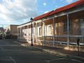
Houses in Santiago's Old Historic Center
-
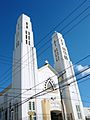
Nuestra Señora de la Altagracia Catholic Church
-
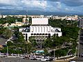
Gran Teatro del Cibao
-
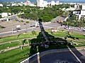
A view of the Northeastern section of Santiago
-

Gran arena del cibao


See also
 In Spanish: Santiago (República Dominicana) para niños
