
Yaque del Norte River facts for kids
Quick facts for kids Yaque del Norte |
|
| River | |
| Country | Dominican Republic |
|---|---|
| Provinces | La Vega, Santiago, Valverde, Santiago Rodríguez, Monte Cristi |
| Tributaries | |
| - left | Guayubín |
| - right | Jimenoa |
| Cities | Jarabacoa, Santiago, Mao, Guayubín, Castañuela, Monte Cristi |
| Primary source | Río Los Guanos |
| - location | Pico del Yaque, Cordillera Central, Dominican Republic |
| - elevation | 2,580 m (8,465 ft) |
| Secondary source | Río Los Tablones |
| Source confluence | |
| - location | La Ciénaga, Cordillera Central, Dominican Republic |
| - elevation | 900 m (2,953 ft) |
| Mouth | Montecristi Bay |
| - location | Monte Cristi, Dominican Republic |
| - elevation | 0 m (0 ft) |
| - coordinates | 19°50′16″N 71°40′58″W / 19.83778°N 71.68278°W |
| Length | 296 km (184 mi) |
| Basin | 7,044 km² (2,720 sq mi) |
| Discharge | for Palo Verde |
| - average | 97.0 m³/s (3,426 cu ft/s) |
The Yaque del Norte is the longest river in the Dominican Republic. It is also the second longest river on the Hispaniola island, after the Artibonite.
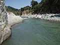
This important river is 296 km long. It flows to the northwest and empties into the Montecristi Bay, which is part of the Atlantic Ocean.
Contents
Name and History
What's in a Name?
The word Yaque or Yaqui comes from the Taíno people. They were the first people living on the Caribbean islands. They used this word for two main rivers. One river, the longest, flows north towards the Atlantic Ocean. This is the Yaque del Norte, meaning "Northern Yaque." The other river flows south to the Caribbean Sea and is called the Yaque del Sur, or "Southern Yaque."
Columbus and the River
When Christopher Columbus first visited America in 1492, he saw the mouth of this river. He called it Río de Oro, which means "Gold River." He gave it this name because he found many small pieces of gold there.
Later, during his second visit, he saw the river in a different spot. He called it Río de las Cañas, meaning "River of Canes." This was because many tall grasses, like sugar cane, were growing along the river's edges. However, neither of these names stuck. People have always called it Yaque, or Yaque del Norte.
Forts Along the River
Columbus also built three forts near the river. These forts were named Esperanza, Magdalena, and Santiago. The first two forts were later left empty. The Santiago fort was moved to a new place and renamed Santiago de los Caballeros. This city was later moved again, still near the river but not in its first spot.
River's Journey
Where the River Starts
The source of the Yaque del Norte is high up in the mountains. It starts at an elevation of 2,580 m. This spot is on the Pico del Yaque mountain, in the middle of the Cordillera Central mountain range.
At this very beginning, the river is called Los Guanos or Río de la Derecha (meaning "River to the Right"). The name Yaque del Norte is used only when this small river joins another small river. This second river is called Los Tablones or Río de la Izquierda (meaning "River to the Left"). They meet in a place called Manabao, west of Jarabacoa, at an elevation of 900 m.
Its Path to the Sea
From Manabao, the river flows east. It goes through the northwestern part of La Vega province. When it reaches Jarabacoa, it turns north towards Santiago. The River Jimenoa joins the Yaque del Norte at Jarabacoa. This is the only important tributary that joins it from the right side.
In Santiago de los Caballeros, the river turns northwest again. It then flows through the Yaque del Norte Valley. This valley is the western part of the Cibao Valley.
The river's mouth is in Montecristi Bay. This is just south of the city of San Fernando de Monte Cristi, on the Atlantic Ocean.
Other Rivers Joining In
The most important tributaries that join the Yaque del Norte from its left side are the rivers Bao, Ámina, Mao, and Guayubín.
Cities Along the Yaque del Norte
The city of Santiago de los Caballeros is the biggest Dominican city located close to the river. The Yaque del Norte also flows near other cities. These include Jarabacoa, Mao, Guayubín, Castañuela, and Monte Cristi.
River's Importance and Uses
River Basin and Water Flow
The Yaque del Norte has a very large watershed. This is the area of land where all the rain and water drain into the river. Its watershed covers 7,044 km². This makes it the largest watershed in the Dominican Republic. It is also the second largest on the island of Hispaniola.
The river's discharge is about 97.0 cubic metres per second. This is the volume of water that flows through a part of the river each second. This measurement is taken at Palo Verde, southeast of San Fernando de Monte Cristi.
How People Use the River
The water from the Yaque del Norte is very important for irrigation. This means using the water to help grow crops. It is mainly used in the valley that stretches from Santiago to Monte Cristi, known as the Yaque del Norte Valley. This valley is very dry, so without the river's water, it would be hard to grow anything. Some of the most important crops grown here with irrigation are rice, bananas, and vegetables like tomato.
Near Jarabacoa, the river is also used for fun water sports. People enjoy activities with canoes and small boats there.
There are several dams built along the river. These dams help to create electricity. They also store water for irrigation and help prevent flooding when there is too much rain.
Images for kids
-
Yaque Del Norte River

See also
 In Spanish: Río Yaque del Norte para niños
