
Santiago Province (Dominican Republic) facts for kids
Quick facts for kids Santiago |
|
| Province | |
 Skyline of Santiago de los Caballeros
|
|
| Country | |
|---|---|
| Development region | Cibao Norte (I) |
| Capital | Santiago de los Caballeros |
| - elevation | 199 m (653 ft) |
| - coordinates | 19°28′48″N 70°41′24″W / 19.48000°N 70.69000°W |
| Area | 2,806.3 km² (1,084 sq mi) |
| Population | 1,503,362 (2014) |
| Density | 536 /km² (1,388 /sq mi) |
| Province since | 1844 |
| Subdivisions | 9 municipalities 16 municipal districts |
| Congresspersons | 1 Senator 18 Deputies |
| Timezone | EST (UTC-4) |
| Area code | 1-809 1-829 1-849 |
| ISO 3166-2 | DO-25 |
Santiago is a Dominican province located in the north-central part of the country. Its capital city is Santiago de los Caballeros. This city is the second largest in the Dominican Republic. The province gets its name from this important city.
The province is in the eastern part of the Yaque del Norte Valley. The Yaque del Norte River flows through this area. The Yaque del Norte Valley is also known as Línea Noroeste, which means "Northwestern Line". It is the western section of the larger Cibao Valley.
Contents
History of Santiago Province
The Santiago province has been a very important administrative area for a long time. It was important even during colonial times. Because it was a key center, its capital city was taken over by French and Haitian armies that came from the northwest border.
How Santiago Province Was Formed
Santiago was one of the first five provinces created by the Dominican Constitution in 1844. Its original territory covered a large area in the northwest. This included parts of the north coast, from Monte Cristi and Dajabón in the west to Moca in the east. Moca later became part of the La Vega province in 1854.
Changes to Santiago's Borders
Over the years, several new provinces were created from parts of Santiago's original territory.
- Puerto Plata was formed in 1865.
- Monte Cristi was created in 1879.
- Dajabón was formed in 1938.
- Santiago Rodríguez was created in 1950.
- Finally, Valverde was formed in 1959.
Growth of Municipalities and Districts
San José de las Matas has been a municipality in the province since 1844. Other municipalities were created later:
- Jánico in 1881
- Tamboril in 1907
- Bisonó in 1961
- Licey al Medio in 1984
- Villa González in 1991
- Puñal in 2006
- Sabana Iglesia in 2007
The municipal districts were also created over time:
- 1983: Pedro García
- 1993: Baitoa
- 1997: La Canela
- 1998: Juncalito and El Rubio
- 2001: San Francisco de Jacagua and Palmar Arriba
- 2002: El Limón
- 2003: Hato del Yaque, Las Placetas and La Cuesta
- 2004: El Caimito
- 2005: Las Palomas
- 2006: Canca la Piedra, Guayabal and Canabacoa
Where is Santiago Province Located?
The Santiago province shares borders with several other provinces.
- To the northwest, it borders Valverde.
- To the north, it borders Puerto Plata.
- To the east, it borders Espaillat and La Vega provinces.
- To the south, it borders San Juan.
- To the west, it borders Santiago Rodríguez.
 |
Valverde | Puerto Plata | |
|
| Santiago Rodríguez | Espaillat | |||
| San Juan | La Vega |
Population of Santiago Province
In 2014, the last national census counted 1,503,362 people living in Santiago province. About 728,484 of these people lived in towns and cities. The population density was about 535.7 people per square kilometer.
Santiago's population makes up about 15.92% of the total population of the Dominican Republic. It is the 3rd most populated province out of 31 provinces and the National District.
As of 2016, the estimated population of the province is 1,015,397 people.
The largest city in the province is Santiago de los Caballeros. This city is the capital and had an urban population of 550,753 people in 2014.
Geography of Santiago Province
The Santiago province covers a total area of 2,806.3 km2 (1,083.5 sq mi). This is about 5.8% of the total area of the Dominican Republic. It is the 3rd largest province in the country.
The capital city, Santiago de los Caballeros, is located 199 m (653 ft) above sea level.
Main Geographic Regions
The province of Santiago has three main geographic regions:
- The Cordillera Septentrional (Northern mountain range) in the north.
- The Yaque del Norte Valley in the center.
- The Cordillera Central (Central mountain range) in the south.
The Northern Mountains
The Cordillera Septentrional mountain range runs across the northern part of the province. The highest mountain in this range is Pico Diego de Ocampo. It is 1,249 m (4,098 ft) high and is located on the border with the Puerto Plata province. This mountain range is covered with rainforests. This is because it rains a lot there. The trade winds, which come from the northeast (from the Atlantic Ocean), bring a lot of water that falls on these mountains.
The Yaque del Norte Valley
South of the Cordillera Septentrional is the Yaque del Norte Valley. From the city of Santiago de los Caballeros to the west, this valley is very dry. The trade winds cannot go over the Cordillera Septentrional, so it does not rain enough in the valley. However, people in this area use the water from the Yaque del Norte river for farming.
The Central Mountains
The Cordillera Central is in the southern half of the province. The highest mountains in the country, the island, and the Caribbean are found here. These are on the border with the San Juan province. Pico Duarte is one of them, standing at 3,098 m (10,164 ft). Other peaks are also above 3,000 m (9,800 ft). This mountain range is covered with pine forests. However, near rivers, you can find rainforests.
Important Rivers
The most important river in the province is the Yaque del Norte River. It flows through the province from south to north, then turns to the northwest. All other rivers in the province are tributaries (smaller rivers that flow into a larger one) of the Yaque del Norte. The only exception is the Licey river, which comes from the Cordillera Septentrional and flows east. The Licey river is a tributary of the Yuna river.
Climate in Santiago
The province has a tropical climate. This means it is hot for most of the year. However, it is cooler in the mountains.
Municipalities and Districts
Santiago province has 9 municipalities and 16 municipal districts (M.D.).

| Municipality (code) |
Municipal Districts (code) | Population (2010) |
Area (km2) |
Density | Altitude (m) |
|---|---|---|---|---|---|
| Santiago de los Caballeros (250101) | 591,985 | 165.0 | 3,587.8 | 199 | |
| Pedro García (250102) | 4,006 | 52.6 | 76.2 | 454 | |
| Baitoa (250103) | 11,778 | 42.9 | 274.5 | 248 | |
| La Canela (250104) | 17,067 | 93.4 | 182.7 | 175 | |
| San Francisco de Jacagua (250105) | 36,902 | 82.3 | 448.4 | 217 | |
| Hato del Yaque (250106) | 29,524 | 38.0 | 776.9 | 176 | |
| Santiago (250100) | 691,262 | 474.1 | 1,458.1 | ||
| Bisonó (250201) | 42,092 | 92.6 | 454.6 | 129 | |
| Bisonó (250200) | 42,092 | 92.6 | 454.6 | ||
| Santo Tomás de Jánico (250301) | 7,672 | 125.7 | 61.0 | 417 | |
| Juncalito (250302) | 4,215 | 178.1 | 23.7 | 895 | |
| El Caimito (250303) | 5,106 | 99.4 | 51.4 | 370 | |
| Jánico (250300)) | 16,993 | 403.2 | 42.1 | ||
| Licey al Medio (250401) | 13,147 | 14.7 | 894.4 | 199 | |
| Las Palomas (250402) | 12,392 | 12.3 | 1,007.5 | 188 | |
| Licey al Medio (250400)) | 25,539 | 27.0 | 945.9 | ||
| San José de las Matas (250501) | 23,850 | 675.1 | 35.3 | 541 | |
| El Rubio (250502) | 7,201 | 584.6 | 12.3 | 503 | |
| La Cuesta (250503) | 3,622 | 111.7 | 32.4 | 433 | |
| Las Placetas (250504) | 3,955 | 147.5 | 26.8 | 832 | |
| San José de las Matas (250500)) | 38,628 | 1,518.8 | 25.4 | ||
| Tamboril (250601) | 39,700 | 45.0 | 882.2 | 266 | |
| Canca La Piedra (250602) | 11,995 | 25.6 | 468.6 | 270 | |
| Tamboril (250600)) | 51,695 | 70.6 | 732.2 | ||
| Villa González (250701) | 27,304 | 56.0 | 487.6 | 164 | |
| Palmar Arriba (250702) | 6,365 | 12.5 | 509.2 | 203 | |
| El Limón (250703) | 3,680 | 32.3 | 113.9 | 399 | |
| Villa González (250700)) | 37,349 | 100.8 | 370.5 | ||
| Puñal (250801) | 23,856 | 23.9 | 998.2 | 167 | |
| Guayabal (250802) | 11,509 | 29.0 | 396.9 | 197 | |
| Canabacoa (250803) | 11,151 | 7.8 | 1,429.6 | 191 | |
| Puñal (250800)) | 46,516 | 60.8 | 765.1 | ||
| Sabana Iglesia (250901) | 13,348 | 58.3 | 229.0 | 252 | |
| Sabana Iglesia (250900)) | 13,348 | 60.8 | 229.0 | ||
| Santiago (250000) | 1,503,362 | 2,806.3 | 535.7 | ||
Economy of Santiago Province
The economy of Santiago province mainly relies on farming and industry. Since the province does not have a coast, tourism is not as important as in other parts of the country.
Santiago is the second largest economic center in the Dominican Republic. It is only smaller than the Greater Santo Domingo area. This area includes the Distrito Nacional and the Santo Domingo Province. Santiago has a lot of commerce and many industries. These include textiles, food, and cement. Most of these industries are in Santiago de los Caballeros and Tamboril. The tobacco industry is also very important in Villa Bisonó.
Farming and Agriculture
Farming is a very important part of the province's economy.
- Poultry (chickens) and pigs are raised in Licey al Medio.
- Cattle (cows) are raised in the south-central and western parts of the province.
- Coffee is grown in the mountains.
- Plantain and cassava are grown in Licey al Medio.
- Rice, fruits, and vegetables are grown in the western part of the province.
- Tobacco is grown in all the lowlands of the province. The best types are grown around the cities of Bisonó and Villa González.
Images for kids
-
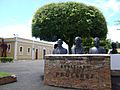
Fortaleza San Luis.
-

Santiago de los Caballeros, Dominican Republic.
-
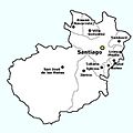
Municipalities of the Province.
-
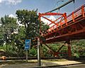
Bridge in Santiago, Dominican Republic.


See also
 In Spanish: Provincia de Santiago (República Dominicana) para niños
