
Puerto Plata Province facts for kids
Quick facts for kids Puerto Plata |
||
| Province | ||
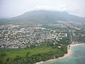
 Aerial view of the city of Puerto Plata
|
||
|
||
| Country | ||
|---|---|---|
| Development region | Cibao Norte (I) | |
| Capital | Puerto Plata | |
| - elevation | 44 m (144 ft) | |
| - coordinates | 19°48′0″N 70°41′0″W / 19.80000°N 70.68333°W | |
| Lowest point | Atlantic Ocean | |
| - elevation | 0 m (0 ft) | |
| Area | 1,805.6 km² (697 sq mi) | |
| Population | 470,839 (2014) | |
| Density | 261 /km² (676 /sq mi) | |
| Province since | 1865 | |
| Subdivisions | 9 municipalities 12 municipal districts |
|
| Congresspersons | 1 Senator 6 Deputies |
|
| Timezone | EST (UTC-4) | |
| Area code | 1-809 1-829 1-849 | |
| ISO 3166-2 | DO-18 | |

The Puerto Plata Province is a province in the northern part of the Dominican Republic. It's a very popular place for tourists, especially because of its many beautiful beaches. The main city and capital of the province is San Felipe de Puerto Plata.
Contents
About Puerto Plata
How Puerto Plata Got Its Name
The province is named after its capital city, Puerto Plata. When Christopher Columbus first visited the northern coast of the Hispaniola island in 1493, he saw a mountain with clouds on its top. He called it Monte de Plata, which means "Mountain of Silver". The town later built at the foot of this mountain was named Puerto de Plata, meaning "Port of Silver". Over time, the name was shortened to just Puerto Plata.
A Look at History
The first European town in the Americas, La Isabela, was founded by Columbus in January 1493 near where Puerto Plata city is today. The city of Puerto Plata itself was founded in 1502.
In 1605, several towns, including Puerto Plata, were destroyed by the governor, Antonio de Osorio. This happened because there was a lot of trade happening that was against the rules. People from these towns had to move closer to the capital city. These movements helped form new towns like Monte Plata and Bayaguana.
Puerto Plata became a special administrative area, similar to a province, in 1865. Before that, it was part of the Santiago province. In 1907, the Dominican Constitution officially made it a province. It included the municipalities of Puerto Plata, Altamira, Blanco, and Bajabonico.
Over the years, more municipalities and municipal districts were added. For example, Sosúa and Los Hidalgos became municipalities in 1978. Villa Isabela, Guananico, and Villa Montellano also became municipalities later.
Where is Puerto Plata?
The Puerto Plata province is located along the northern coast of the island.
- To the north, it borders the Atlantic Ocean.
- To the east, it's next to the Espaillat province.
- To the south, you'll find the Santiago and Valverde provinces.
- To the west, it shares a border with the Monte Cristi province.
 |
Atlantic Ocean | |
||
| Monte Cristi | Espaillat | |||
| Valverde | Santiago |
People of Puerto Plata
In 2014, the last time a national census (a count of all people) was done, there were 470,839 people living in the Puerto Plata province. About 187,767 of these people lived in towns and cities. This means the province has about 260.8 people per square kilometer.
The province is the 6th most populated province in the Dominican Republic. As of As of 2016[update], the estimated population was 329,482 people.
The largest city in the province is San Felipe de Puerto Plata. In 2014, its city population was 118,496 people. Most of the people living in Puerto Plata are of mixed heritage.
Geography and Nature
The Puerto Plata province covers an area of about 1,805.6 km2 (697.1 sq mi). This makes it the 10th largest province in the Dominican Republic.
The Cordillera Septentrional, which means "Northern mountain range", runs through the southern part of the province. Another mountain range, Sierra Atravesada, stretches from the Cordillera Septentrional towards the coast. The famous mountain "Isabel de Torres", which Columbus called "Monte de Plata", is close to the city of San Felipe de Puerto Plata.
Because the mountains are close to the coast, the rivers in this province are not very long. The most important rivers are the Bajabonico, Yásica, and Camú del Norte. The city of San Felipe de Puerto Plata is about 44 m (144 ft) above sea level.
Local Government
The province is divided into nine municipalities and 12 municipal districts. These are like smaller local government areas.

What Drives the Economy?
Puerto Plata has several important ways that people make a living:
- Tourism: Many visitors come to the beautiful coastal areas.
- Farming: Agriculture is important, with people growing various crops.
- Industry: There are factories that produce goods like food products and rum.
Gallery


.jpg)

Images for kids
-
Puerto Plata
See also
 In Spanish: Provincia de Puerto Plata para niños
