
Monte Cristi Province facts for kids
Quick facts for kids Monte Cristi |
||
| Province | ||
 Beach in El Morro, Monte Cristi
|
||
|
||
| Country | ||
|---|---|---|
| Development region | Cibao Noroeste (IV) | |
| Capital | Monte Cristi | |
| - elevation | 16 m (52 ft) | |
| - coordinates | 19°51′0″N 71°39′0″W / 19.85000°N 71.65000°W | |
| Lowest point | Atlantic Ocean | |
| - location | 0 | |
| Area | 1,885.8 km² (728 sq mi) | |
| Population | 150,833 (2014) | |
| Density | 80 /km² (207 /sq mi) | |
| Province since | 1879 | |
| Subdivisions | 6 municipalities 4 municipal districts |
|
| Congresspersons | 1 Senator 2 Deputies |
|
| Timezone | EST (UTC-4) | |
| Area code | 1-809 1-829 1-849 | |
| ISO 3166-2 | DO-15 | |

Monte Cristi is a special area called a province in the north-west part of the Dominican Republic. Think of a province like a big county or state. Its main city is San Fernando de Monte Cristi, often just called Monte Cristi. You might also see its name spelled as Montecristi.
Contents
The Name of Monte Cristi
When Christopher Columbus first explored the northern coast of the Hispaniola island, he saw a unique mountain on January 4, 1493. This mountain looked like a dromedary (a type of camel). He named it Monte Cristo or Monte Christi, which means "Mountain of Christ". Today, this mountain is known as El Morro. It's very close to the city of San Fernando de Monte Cristi.
A Brief History of Monte Cristi
Nicolás de Ovando started a small fishing village where Monte Cristi is now. Later, in 1533, Juan de Bolaños brought 60 families from the Canary Islands to live there. In 1545, 30 more families joined them.
However, in 1606, the Spanish Crown ordered the town to be destroyed. The people living there, along with those from Puerto Plata, were moved away from the northern coast. They were relocated to form a new town called Monte Plata.
But Monte Cristi was not forgotten! In 1751, King Ferdinand VI of Spain ordered the town to be rebuilt.
Monte Cristi became a "Maritime District" in 1879. This was a special type of administrative area, similar to a province, but it's not used anymore. In 1907, the Dominican Constitution officially made it a full province. Before that, it was part of the Santiago province.
Over the years, other towns in the province grew. Guayubín became a municipality in 1855, and Villa Vásquez in 1938. Pepillo Salcedo became a municipality in 1949, Castañuelas in 1974, and Las Matas de Santa Cruz in 1985. Smaller areas like Villa Elisa and Hatillo Palma became municipal districts in 1997. Cana Chapetón followed in 1999, and Palo Verde in 2002.
Where is Monte Cristi Located?
The Monte Cristi province is in the north-west of the Dominican Republic. It has some interesting neighbors!
- To the north and west, it borders the Atlantic Ocean.
- To the east, you'll find the Puerto Plata and Valverde provinces.
- To the south, it's next to the Dajabón and Santiago Rodríguez provinces.
 |
Atlantic Ocean | Puerto Plata | |
|
| Atlantic Ocean | Valverde | |||
| Dajabón | Santiago Rodríguez |
Population of Monte Cristi Province
In 2014, which was the last time a national count was done, there were about 150,833 people living in Monte Cristi province. A large part of these people, about 58,224, lived in the towns and cities.
The province is not very crowded. Its population density was about 80.0 people per square kilometer. This means there's plenty of space!
Monte Cristi's population is about 1.6% of the total population of the Dominican Republic. Out of all the provinces, Monte Cristi is the 21st most populated.
As of As of 2016[update], it was estimated that the province had about 114,624 people living there.
The biggest city in the province is Monte Cristi itself. It's the capital city. In 2014, about 24,644 people lived in Monte Cristi city.
Geography and Landscape
The Monte Cristi province covers a total area of about 1,885.8 km2 (728.1 sq mi). This makes it the 9th largest province in the Dominican Republic. It takes up about 3.9% of the country's total land area.
The capital city, San Fernando de Monte Cristi, is about 16 m (52 ft) above sea level. This means it's very close to the ocean's surface.
Monte Cristi province is located in the north-western part of the Cibao Valley. This area is also known as the Yaque del Norte Valley or Línea Noroeste. It's a very dry place because it doesn't get much rain.
The most important river here is the Yaque del Norte. It's the longest river in the Dominican Republic! Other rivers like Guayubín and Maguaca flow into the Yaque del Norte. These smaller rivers are called tributaries.
Along the northern coast of the province, there's a mountain range called the Cordillera Septentrional (which means "Northern mountain range"). These aren't super tall mountains, but rather low hills. At the very end of this mountain range, you'll find the famous "El Morro" mountain. It forms a unique headland or a small peninsula that sticks out into the sea.
Climate of Monte Cristi
The climate in Monte Cristi province is tropical. This means it's hot for most of the year.
Local Government: Municipalities and Districts
Monte Cristi province is divided into six main areas called municipalities. Within these municipalities, there are also four smaller areas called municipal districts (M.D.).

| Municipality (code) |
Municipal Districts (code) | Population (2010) |
Area (km2) |
Density | Altitude (m) |
|---|---|---|---|---|---|
| San Fernando de Monte Cristi (150101) | 24,644 | 517.4 | 47.6 | 16 | |
| Monte Cristi (150100) | 24,644 | 517.4 | 47.6 | ||
| Castañuelas (150201) | 9,468 | 50.6 | 187.1 | 21 | |
| Palo Verde (150202) | 5,453 | 36.1 | 151.1 | 17 | |
| Castañuelas (150200) | 14,921 | 86.8 | 171.9 | ||
| Guayubín (150301) | 12,464 | 263.3 | 47.3 | 39 | |
| Villa Elisa (150302) | 7,430 | 215.4 | 34.5 | 87 | |
| Hatillo Palma (150303) | 8,802 | 133.3 | 66.0 | 71 | |
| Cana Chapetón (150304) | 7,227 | 222.0 | 32.6 | 60 | |
| Guayubín (150300) | 35,923 | 834.0 | 43.1 | ||
| Las Matas de Santa Cruz (150401) | 10,559 | 71.9 | 146.9 | 46 | |
| Las Matas de Santa Cruz (150400) | 10,559 | 71.9 | 146.9 | ||
| Pepillo Salcedo (150501) | 9,136 | 151.2 | 60.4 | 11 | |
| Pepillo Salcedo (150500) | 9,136 | 151.2 | 60.4 | ||
| Villa Vásquez (150601) | 14,424 | 224.6 | 64.2 | 40 | |
| Villa Vásquez (150600) | 14,424 | 224.6 | 64.2 | ||
| Monte Cristi (150000) | 150,833 | 1885.8 | 80.0 | ||
Economy and What People Do
The main way people earn a living in Monte Cristi province is through farming. They grow important crops like bananas and rice.
Fishing is also a big deal, especially in the capital city of San Fernando de Monte Cristi. Another important activity there is producing salt.
Images for kids
-
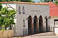
Montecristi town museum.
-
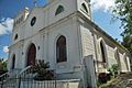
Church of Montecristi, Dominican Republic.
-
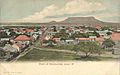
Montecristi in 1906.
-
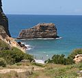
Morro de Montecristi.
-
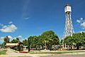
Clock-tower of Montecristi.


See also
 In Spanish: Provincia de Monte Cristi para niños
