
Pico Duarte facts for kids
Quick facts for kids Pico Duarte |
|
|---|---|

View from La Pelona summit, 1996
|
|
| Highest point | |
| Elevation | 3,101 m (10,174 ft) |
| Prominence | 3,098 m (10,164 ft) |
| Listing |
|
| Geography | |

Pico Duarte
Location in the Dominican Republic
|
|
| Location | San Juan Province, |
| Parent range | Cordillera Central |
| Climbing | |
| First ascent | 1851 by Robert H. Schomburgk |
| Easiest route | Hike |
Pico Duarte is the tallest mountain in the Dominican Republic. It is also the highest point on the island of Hispaniola and in the entire Caribbean region. This amazing peak stands about 3,101 m (10,174 ft) above sea level.
Because of its height, Hispaniola ranks as the 16th island in the world with the highest peak. Pico Duarte is part of the Cordillera Central mountain range. This range stretches across the Dominican Republic and into Haiti. In Haiti, it is known as the Massif du Nord.
Contents
History of Pico Duarte
Early Explorations and Naming
The first recorded climb of Pico Duarte was in 1851. A German man named Sir Robert Hermann Schomburgk made this climb. He was a British consul, which means he was a government official representing his country. Schomburgk named the mountain "Monte Tina." He thought it was about 3,140 metres (10,300 ft) tall.
Later, in 1912, a priest named Father Miguel Fuertes climbed a nearby peak, La Rucilla. He believed La Rucilla was taller than Monte Tina. However, a year later, a Swedish botanist named Erik Leonard Ekman agreed with Schomburgk's measurements. Ekman called the two main peaks "Pelona Grande" and "Pelona Chica." These names mean "Big Bald One" and "Small Bald One."
Changing Names and Honors
During the time of Rafael Trujillo, a former leader of the Dominican Republic, the taller peak was called "Pico Trujillo." After Trujillo's death, the mountain was renamed Pico Duarte. This was done to honor Juan Pablo Duarte. He was one of the important founding fathers of the Dominican Republic.
At the very top of Pico Duarte, there is a bronze statue of Juan Pablo Duarte. It sits on a stone base. Next to it, a flagpole proudly flies the Dominican flag. There is also a cross at the summit.
Geography of the Mountain
Measuring the Height
For many years, people debated the exact height of Pico Duarte. In the mid-1990s, it was thought to be 3,175 metres (10,417 ft) high. Then, in 2003, a researcher used GPS technology to measure it. The new measurement was 3,098 metres (10,164 ft).
Dominican government groups officially record the height as 3,087 metres (10,128 ft). Many hikers have confirmed this using their own GPS devices. The most recent measurement in 2021 used advanced GSSM technology. This showed the altitude to be 3,101.1 meters, with only a small margin of error.
Pico Duarte and La Pelona
Pico Duarte is only a few meters taller than its twin peak, La Pelona. La Pelona stands at about 3,097 metres (10,161 ft). A low area between the two peaks separates them. This area is called a col. It is about 1.5 kilometres (0.93 mi) wide.
The official name for this col is Valle del Baíto. However, many people unofficially call it Valle de Lilís. The average height of this pass is about 2,950 metres (9,680 ft).
Nature on Pico Duarte
Climate and Forests
The area around Pico Duarte has a unique climate for a Caribbean island. It has cool temperatures all year round. During winter nights, temperatures can even drop below freezing.
The mountain and its surroundings are covered in pino de cuaba or Pinus occidentalis pine forests. These pine trees often host other plants called epiphytes. Epiphytes, like guajaca (Tillandsia species), grow on other plants but do not harm them. There are also parasitic plants, such as Dendropemon pycnophyllus, which get nutrients from the pines.
Meadows and Understory Plants
Some parts of the area, like the Valle de Lilís, do not have trees. These are meadows filled with tussock-like pajones (Danthonia domingensis). Below the main trees, you can find many shrubs. These include Lyonia heptamera, Myrica picardae, and Myrsine coriacea. Other shrubs are Ilex tuerkheimii, Garrya fadyenii, and Baccharis myrsinites. All these plants are used to the acidic soil found in this region.
Animals of the Mountain
Many interesting animals live around Pico Duarte. Reptiles include the Panolopus marcanoi, which is found only here. Birds you might see are the Hispaniolan palm crow and the Antillean siskin. Other birds include the rufous-throated solitaire and the Hispaniolan crossbill. The number of Hispaniolan crossbills depends on how many pine cones are available. The Hispaniolan trogon is also found here.
At lower heights, you might spot the Hispaniolan amazon parrot or the scaly-naped pigeon. The rare golden swallow can also be seen. Two mammals found only on Hispaniola live in the lower broadleaf forests. These are the Hispaniolan solenodon, which is mostly active at night, and the Hispaniolan hutia. Both are rarely seen, and the hutia is considered endangered. You might also see Wild boar, which are descendants of animals brought to the island long ago.
Wildfire Impact
In 2003, a wildfire changed a large part of the eastern side of the mountain. By 2008, the hillside of burned trees was starting to grow back. Thousands of charred trees still stand, but many local grasses and small plants are now growing there.
Climbing Pico Duarte
Trails and Routes
There are several trails that lead to the summit of Pico Duarte. The easiest way to start your climb is from the town of La Ciénaga, near Jarabacoa. This trail is about 23.1 km (14.4 mi) long to the summit. You will climb about 1,977 metres (6,486 ft) in total height.
About 5 kilometres (3.1 mi) from the summit, there is a shelter called La Comparticion. Many travel agencies can help you plan trips from La Ciénaga. They often use mules to carry food, sleeping bags, and supplies for your overnight stay at the shelter.
Water and Safety Tips
Along the trail, you will find a few fresh water springs marked as "potable" (safe to drink). However, it is always a good idea to use water filters or purifying tablets. Most hikers choose this route.
Longer Expeditions
Another starting point is northwest of the town of San Juan de la Maguana. Trips from here usually last four days and three nights. They can end at the La Ciénaga trailhead or return to the starting point. Local Dominicans organize these trips. They cook food and help campers along the way.
You will spend each night in shelters. Because of the long distance, riding a mule is highly recommended. This route is less traveled, so you might not see other hikers until you join the trail from La Ciénaga.
Visitor Numbers
According to park officials in La Ciénaga, about 1,000 hikers visit Pico Duarte in December and January. These are popular months. During other times of the year, only about 10 to 15 people hike the mountain each day.
See also
 In Spanish: Pico Duarte para niños
Images for kids
-
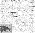
Topographical map of the Pico Duarte massif and its location in the Dominican Republic
-
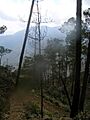
Approaching the peak of Pico Duarte.
-
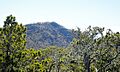
Hispaniolan pine forests on Pico Duarte


