
Geography of the Dominican Republic facts for kids
| Geography of the Dominican Republic |
|
 |
|
| Continent | Americas |
| Region | Caribbean |
| Coordinates | 18°52' N 70°29' W |
| Area | Ranked 127 48,671 km² |
| Coastline | 1,288 km |
| Borders | 388 km |
| Highest point | Pico Duarte 3,098 m |
| Lowest point | Lake Enriquillo -46 m |
| Longest river | Yaque del Norte |
| Largest lake | Lake Enriquillo |
The Dominican Republic (which is República Dominicana in Spanish) is a beautiful country located in the Caribbean region. It shares an island called Hispaniola with its neighbor, Haiti. The Dominican Republic covers the eastern five-eighths of the island, while Haiti takes up the western three-eighths. The border between these two countries is about 388 kilometers long.
This country has a total area of 48,671 square kilometers. Most of this area (48,215 km²) is on the main island of Hispaniola. The rest is made up of smaller Dominican islands, covering about 159 km². From east to west, the country stretches about 390 km. From north to south, it is about 265 km wide.
The Dominican Republic is surrounded by water on three sides. The Atlantic Ocean is to the north, and the Caribbean Sea is to the south. To the west, it borders Haiti. To the southeast, across a channel about 130 km wide, is Puerto Rico. The country's capital, Santo Domingo, is located on the southern coast.
Contents
What is the Climate Like in the Dominican Republic?
The Dominican Republic has a tropical climate, which means it's generally warm all year round. However, the weather can change depending on how high up you are (your elevation) and because of special winds called trade winds. These winds blow from the northeast, coming from the Atlantic Ocean, throughout the year.
The average yearly temperature is about 25°C (77°F). Temperatures don't change much from one season to another. However, different regions of the country can have different average temperatures. For example, in the center of the Cordillera Central mountains, it might be around 21°C (70°F). But on the coastal plains, it can be as warm as 28°C (82°F). It's rare for temperatures to go above 32°C (90°F). In the highest mountains, temperatures can drop below 0°C (32°F) during winter. In Santo Domingo, the average temperature is 25°C (77°F) in January and 30°C (86°F) in July.
The rainy season usually lasts from May to November. On average, the country gets about 1,346 millimeters (53 inches) of rainfall each year. Some areas, like the northeastern mountains, can get a lot more rain (2,500 mm or more). But other places, like the southwestern valleys, are much drier, receiving only about 500 mm (20 inches). The western valleys near the Haitian border and the far northwestern and southeastern parts of the country are also very dry.
From June to November, especially from August to October, tropical storms and hurricanes are common. These powerful storms can cause a lot of damage across the country.
Exploring the Islands of the Dominican Republic
Besides the main island of Hispaniola, the Dominican Republic includes several smaller islands and cays. Here are some of the largest and most interesting ones:
- Saona Island: This island is located near the southeastern coast of Hispaniola in the Caribbean Sea. It covers an area of 117 square kilometers. Its original Taíno name was Iai or Adamanay. When Christopher Columbus discovered it, he named it Savona, after an Italian city. Over time, the "v" was dropped, and it became Saona.
- Beata Island: You can find Beata Island off the southern coast of Hispaniola, also in the Caribbean Sea. It's smaller, with an area of 27 square kilometers. We don't know its original Taíno name. Columbus named this island Madama Beata.
- Catalina Island: This island is very close to the southeastern coast of Hispaniola, in the Caribbean Sea. It's about 9.6 square kilometers in size. Its Taíno name was Iabanea, though some writers say it was called Toeya or Toella. Columbus discovered it and named it Santa Catalina.
Some other small cays include the Cayos Siete Hermanos (which means "Seven Brothers Cays"), located near the northwestern coast, and the cays found in Samaná Bay.
Dominican Republic's Mountains and Valleys

The Dominican Republic is a very mountainous country! In fact, the highest peaks in the entire Caribbean region are found here. The main mountain chains generally run from northwest to southeast. Between these mountain ranges, you'll find valleys that also follow the same general direction.
Let's explore the main mountain ranges and valleys from north to south:
- Cordillera Septentrional (Northern Range): This mountain range runs parallel to the northern coast. It extends northwest towards Tortuga Island (north of Haiti) and southeast to the Samaná Peninsula, where it's called the Sierra de Samaná. Its highest mountain is Diego de Ocampo, near the city of Santiago, which is 1,249 meters tall. There are several small plains between this range and the Atlantic Ocean. The rivers here are short and mostly flow north.
- Cibao Valley: This is the largest and most important valley in the country. It's a long valley that stretches from Northern Haiti (where it's called Plaine du Nord) all the way to Samaná Bay. It can be divided into two main parts: the northwestern part is the Yaque del Norte Valley (also known as Línea Noroeste), and the eastern part is the Yuna Valley (or Vega Real, meaning Royal Valley). The Vega Real has some of the best soils in the country, and many people live there.
- Cordillera Central (Central Range): This range is also sometimes called Sierra del Cibao and in Haiti, it's known as the Massif du Nord. With its very high mountains, it effectively divides the country into two halves. The highest mountains in the West Indies are found here, including Pico Duarte, which stands at 3,098 meters (10,164 feet) tall, and other peaks over 3,000 meters. Near the center of the island, this range turns southward and is called Sierra de Ocoa, ending near the city of Azua de Compostela on the Caribbean coast. Another branch, the Cordillera Oriental (Eastern Range) or Sierra del Seibo, is separated from the main chain by a region called Los Haitises. This eastern range runs from west to east and is located south of Samaná Bay.
- San Juan Valley and Plain of Azua: These are large valleys located south of the Cordillera Central. Their altitudes range from 0 to 600 meters.
- Sierra de Neiba: Mount Neiba is the highest mountain in this range, reaching 2,279 meters. An extension of the Sierra de Neiba to the southeast is the Sierra Martín García, with its highest point, Loma Busú, at 1,350 meters.
- Hoya de Enriquillo or Neiba Valley: This is a very unique valley that runs from west to east. It has a low altitude, averaging about 50 meters, with some parts even below sea level! It's home to a large salt lake called Enriquillo Lake.
- Sierra de Bahoruco: In Haiti, this southern group of mountains is called Massif de la Selle. The geology (the study of rocks and how the Earth is formed) of these mountains is quite different from the rest of the island.
- Llano Costero del Caribe (Caribbean Coastal Plain): This large prairie is located in the southeast of the island and the Dominican Republic, east of Santo Domingo.
Rivers and Lakes of the Dominican Republic
The Dominican Republic has many important rivers and lakes. Here are the 8 longest rivers:
- Yaque del Norte: This is the longest river in the Dominican Republic, stretching 296 km. It starts in the Cordillera Central mountains and flows through the Yaque del Norte Valley all the way to the Atlantic Ocean. Its watershed (the area of land where all the water drains into this river) covers 7,044 km².
- Yuna River: The Yuna is 209 km long. It also begins in the Cordillera Central and flows east through the Vega Real to Samaná Bay. Its watershed is 5,498 km².
- Yaque del Sur River: This river is 183 km long and also starts in the Cordillera Central. It flows south into the Caribbean Sea. Its watershed covers 4,972 km².
- Ozama: The Ozama River is 148 km long. Its source is in the Sierra de Yamasá, which is part of the Cordillera Central. It flows into the Caribbean Sea. The city of Santo Domingo is built on both sides of this river. Its watershed is 2,685 km².
- Camú River: This river is 137 km long. It starts in the Cordillera Central and flows into the Yuna River. Its watershed is 2,655 km².
- Nizao River: The Nizao River is 133 km long. It begins in the Cordillera Central and flows south into the Caribbean Sea. Its watershed covers 974 km².
- San Juan River: This river is 121 km long. It starts in the Cordillera Central and flows south through the San Juan Valley. It's the main tributary (a smaller river that flows into a larger one) of the Yaque del Sur River. Its watershed is 2,005 km².
- Mao River: The Mao River is 105 km long. It starts in the Cordillera Central and flows north into the Yaque del Norte River. Its watershed covers 864 km².
The Artibonite River is actually the longest river on the entire island of Hispaniola, but only 68 km of it are within the Dominican Republic.
The biggest lake on Hispaniola, and in the entire Caribbean, is Lake Enriquillo. It's located in the Hoya de Enriquillo valley and has an area of 265 km². There are three small islands within the lake. What's really interesting is that it's about 40 meters (131 feet) below sea level, and it's a saltwater lake with even more salt than the ocean!
Other notable lakes include Rincón (which has fresh water and an area of 28.2 km²), Oviedo (which has brackish water, meaning it's a mix of fresh and salt, and an area of 28 km²), Redonda, and Limón.
Images for kids
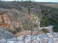
-
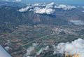
Cordillera Central
-
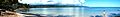
A beach in the Samana province
-
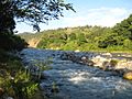
Yaque del Norte river.
-
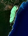
Oviedo Lake in Pedernales.
-
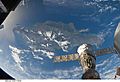
Satellite view of Dominican Republic.
-
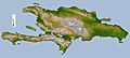
Topography map of Hispaniola
-
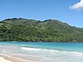
Tropical rainforest climate in Samana.
-
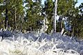
Frosted alpine forest in Constanza.
-
Semi-arid climate in Pedernales.
-
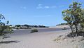
Desert sand dunes of Bani.


_Saman%C3%A1,_DR.JPG)

.JPG)

See also
 In Spanish: Geografía de la República Dominicana para niños
