
Pedernales Province facts for kids
Quick facts for kids Pedernales |
||
| Province | ||
 Bahia de las Aguilas beach, Pedernales
|
||
|
||
| Country | ||
|---|---|---|
| Development region | Enriquillo (VI) | |
| Capital | Pedernales | |
| - elevation | 22 m (72 ft) | |
| - coordinates | 18°2′0″N 71°45′0″W / 18.03333°N 71.75000°W | |
| Lowest point | Caribbean Sea | |
| - elevation | 0 m (0 ft) | |
| Area | 2,080.5 km² (803 sq mi) | |
| Population | 52,165 (2014) | |
| Density | 25 /km² (65 /sq mi) | |
| Province since | 1957 | |
| Subdivisions | 2 municipalities 2 municipal districts |
|
| Congresspersons | 1 Senator 2 Deputies |
|
| Timezone | EST (UTC-4) | |
| Area code | 1-809 1-829 1-849 | |
| ISO 3166-2 | DO-16 | |

Pedernales is a Dominican province located in the southwestern part of the country. It shares a border with Haiti. The capital city of the province is also called Pedernales.
This province was officially created on December 16, 1957. Before becoming a province, Pedernales was a municipality within the Barahona province.
Contents
What's in a Name? The Meaning of Pedernales
The province gets its name from the Pedernales River. This river forms the southern part of the border between Haiti and the Dominican Republic. The river itself was named "Pedernales" because the mineral called flint (which is pedernal in Spanish) is very common in this area.
A Glimpse into Pedernales' Past
Long ago, some native groups lived near the coast and the Pedernales River. However, not many people have lived in this region throughout history. This is mainly because it is a very dry area.
During his second trip to America, Christopher Columbus saw and named parts of the island. This included the Beata and Alto Velo islands, which are now part of Pedernales province.
Until the 20th century, most people living here were Haitians. Many places still have French names. During the Dominican-Haitian War (1844-1856), Haitian soldiers sometimes crossed this region. This was because there were no Dominican soldiers guarding it. The only battle in this area happened near the El Can bay on January 6, 1856.
Since colonial times, this territory was part of the Azua province. It then became part of the Barahona province in 1881. The province of Pedernales was created in 1957. Its main towns were Pedernales, the capital, and Oviedo.
Later, Juancho became a municipal district in 1998. José Francisco Peña Gómez Oviedo became another municipal district in 2005.
Where is Pedernales Located?
The Pedernales province is in the southwest of the Dominican Republic. To the north, it shares a border with the Independencia province. To the northeast, it borders Barahona. The Caribbean Sea is to its east, south, and west. To the far west, Pedernales borders the Republic of Haiti.
 |
Haiti | Independencia | Barahona | |
| Caribbean Sea | Caribbean Sea | |||
| Caribbean Sea |
How Many People Live in Pedernales?
In 2014, the last time a national census was taken, there were 52,165 people living in Pedernales province. About 20,345 of them lived in towns and cities. The population density was about 25.1 people per square kilometer.
The province's population is a small part of the country's total. Pedernales is the 32nd most populated province (out of 31 provinces plus the National District). This means it has the fewest people and the lowest population density.
As of As of 2016[update], the estimated population for the province was 33,755 people.
The largest city in the province is Pedernales. It is the capital city. In 2014, its urban population was 13,077 people.
Exploring Pedernales' Geography
The Pedernales province covers a total area of 2,080.5 km2 (803.3 sq mi). This is about 4.3% of the Dominican Republic's total area. It is the 7th largest province in the country.
The province is part of the Barahona Peninsula. The Sierra de Bahoruco (Bahoruco mountain range) is in the northern half of the province. Its highest point is Loma del Toro, which is 2,367 m (7,766 ft) above sea level. This mountain is on the border with the Independencia province.
The rest of the province has savannas and plains made of limestone rocks. The savannas are near the coast. Examples include the Sansón Savanna in Oviedo and the Pedernales Savanna around the city of Pedernales.
Several small islands are part of the province. The most important ones are Beata and Alto Velo.
The city of Pedernales, the provincial capital, is 22 m (72 ft) above sea level.
The only major river is the Pedernales River. Its smaller branch is called Mulito. The Pedernales River forms the border between the Dominican Republic and Haiti.
There are also several lagoons. A lagoon is a small lake located near the sea. These lagoons have brackish water, meaning it's a mix of fresh and salt water. The most important one is Laguna de Oviedo. It is on the eastern coast near the town of Oviedo and covers an area of 28 km2 (11 sq mi). On the western coast, Laguna Salada is the most important lagoon, with an area of 1.8 km2 (0.7 sq mi).
What is the Climate Like?
The climate in Pedernales province is tropical. This means it is hot for most of the year. However, it is cooler in the mountains. The savannas and plains are very dry, with long periods of drought. But in the high mountains, rain is more common.
Understanding Pedernales' Municipalities
The province of Pedernales has two main municipalities. It also has two municipal districts (M.D.).

| Municipality (code) |
Municipal Districts (code) | Population (2010) |
Area (km2) |
Density | Altitude (m) |
|---|---|---|---|---|---|
| Pedernales (160101) | 14,590 | 883.8 | 16.5 | 22 | |
| José Francisco Peña Gómez (160102) | 9,701 | 237.1 | 40.9 | 845 | |
| Pedernales (160100) | 24,291 | 1,120.9 | 21.7 | ||
| Oviedo (160201) | 3,544 | 806.4 | 4.4 | 33 | |
| Juancho (160202) | 3,752 | 153.2 | 24.5 | 12 | |
| Oviedo (160200)) | 7,296 | 959.6 | 7.6 | ||
| Pedernales (160000) | 52,165 | 2,080.5 | 25.1 | ||
What is the Economy of Pedernales Like?
Like other provinces along the border in the Dominican Republic, Pedernales has limited economic growth. Trading with Haiti is important, especially in the capital city. In the mountains, coffee and beans are key products. Farmers in the Sierra de Bahoruco also grow potatoes, cabbage, and other vegetables.
Fishing is another important activity in the province. This is mainly done near the Beata Island. Fishermen catch lobster, conch, and various kinds of fish.
The province has beautiful beaches on its western coast, such as Bahía de las Águilas ("Eagles Bay"). Because of these beaches, tourism is becoming a significant economic activity. Pedernales is also home to two of the country's largest national parks: the Jaragua National Park and the Sierra de Bahoruco National Park.
The province's development was once driven by the mining of bauxite, which is a type of aluminium ore. However, since 1984, the focus has shifted. Now, they mainly mine limestone to send to other countries and for a local cement factory.
Images for kids
-
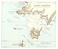
Historical map of Pedernales area.
-
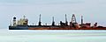
Bauxite mining in Cabo Rojo.
-
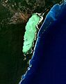
Lago de Oviedo in Jaragua National Park.
-
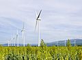
Juancho, Pedernales wind farm.
.jpg)


See also
 In Spanish: Provincia de Pedernales para niños
