
Independencia Province facts for kids
Quick facts for kids Independencia |
||
| Province | ||
|
||
| Country | ||
|---|---|---|
| Development region | Enriquillo (VI) | |
| Capital | Jimaní | |
| - elevation | 31 m (102 ft) | |
| - coordinates | 18°29′24″N 71°51′0″W / 18.49000°N 71.85000°W | |
| Area | 2,007.4 km² (775 sq mi) | |
| Population | 74,583 (2014) | |
| Density | 37 /km² (96 /sq mi) | |
| Province since | 1948 | |
| Subdivisions | 6 municipalities 6 municipal districts |
|
| Congresspersons | 1 Senator 2 Deputies |
|
| Timezone | EST (UTC-4) | |
| Area code | 1-809 1-829 1-849 | |
| ISO 3166-2 | DO-10 | |

Independencia (which means Independence in English) is a Dominican province. It is located in the western part of the country. This province shares a border with Haiti. Its main city and capital is Jimaní.
Contents
Where is Independencia Province?
The Independencia province has neighbors all around it. To the north, it borders the Elías Piña and Bahoruco provinces. To the east, you'll find the Barahona province. The Pedernales province is to its south. On its western side, Independencia shares a border with the country of Haiti.
 |
Elías Piña | Baoruco | |
|
| Haiti | Barahona | |||
| Pedernales |
History of Independencia Province
Independencia became a province on December 29, 1948. However, it officially started operating as a province on January 1, 1950. Before this, it was part of the Bahoruco province. The name "Independencia" was chosen to remember the Dominican Republic's independence from Haiti. This important event happened on February 27, 1844.
When the province was first created, it included the towns (called municipalities) of Jimaní, Duvergé, and La Descubierta. Jimaní was chosen as the capital city. Over the years, more towns became municipalities. Postrer Río became a municipality in 1982. Cristóbal followed in 2003, and Mella in 2004. Smaller areas called municipal districts were also added. These include Guayabal (1998), El Limón (2001), La Colonia (2004), Boca de Cachón and Vengan a Ver (2005), and Batey 8 (2006).
Population of Independencia Province
In 2014, the last time a national count was done, there were 74,583 people living in Independencia province. About 42,050 of these people lived in towns and cities. This means that 56.4% of the population lived in urban areas.
The population density was 37.2 people per square kilometer. This is one of the lowest in the country. Only Pedernales province has fewer people per square kilometer. Independencia province is ranked 31st out of 31 provinces (plus the National District) in terms of population. Its population makes up about 0.79% of the country's total population.
As of As of 2016[update], it is estimated that the province has about 55,638 residents. The largest city in the province is Jimaní. It is the capital and had 10,034 people living there in 2014.
Geography of Independencia Province
Independencia province covers a total area of 2,007.4 km2 (775.1 sq mi). This means it takes up about 4.2% of the Dominican Republic's total land area. It is the 8th largest province in the country.
The southern part of the province is home to the Sierra de Bahoruco mountain range. The Sierra de Neiba mountains run through the northwestern part, along the border with the Elías Piña province. The rest of the province is part of a large valley called the Hoya de Enriquillo (also known as the Neiba Valley).
A very important natural feature in this valley is Lake Enriquillo. About half of this large lake is located within the Independencia province. The capital city, Jimaní, is about 48 m (157 ft) above sea level.
There are not many rivers in the province that flow all year round. The longest river is the Las Damas river, which is about 24 km (15 mi) long. It flows from the Sierra de Bahoruco mountains into Lake Enriquillo.
The province also has important protected areas. These include the Parque Nacional Sierra de Baoruco (Sierra de Baoruco National park) and the Parque Nacional Lago Enriquillo (Enriquillo Lake National park). These parks help protect the unique plants and animals of the region.
Climate
The climate in Independencia province is tropical. This means it is generally very hot and dry in the valley areas. However, it gets cooler as you go higher up into the mountains.
Municipalities and Districts
Independencia province is divided into 6 main towns, called municipalities. It also has 6 smaller areas called municipal districts (M.D.). These districts are part of the municipalities.

Here is a list of the municipalities and their municipal districts:
| Municipality (code) |
Municipal Districts (code) | Population (2010) |
Area (km2) |
Density | Altitude (m) |
|---|---|---|---|---|---|
| Jimaní (100101) | 10,034 | 200.6 | 50.0 | 48 | |
| El Limón (100102) | 3,381 | 144.2 | 23.4 | 29 | |
| Boca de Cachón (100103) | 3,095 | 201.8 | 15.3 | 15 | |
| Jimaní (100100) | 16,510 | 546.6 | 30.2 | ||
| Duvergé (100201) | 9,321 | 353.3 | 26.4 | 8 | |
| Vengan a Ver (100202) | 2,708 | 180.5 | 15.0 | 8 | |
| Duvergé (100200)) | 12,029 | 533.7 | 22.5 | ||
| La Descubierta (100301) | 8,310 | 215.5 | 38.6 | 41 | |
| La Descubierta (100300) | 8,310 | 215.5 | 38.6 | ||
| Postrer Río (100401) | 3,596 | 92.0 | 39.1 | 41 | |
| Guayabal (100402) | 2,072 | 72.3 | 28.7 | 337 | |
| Postrer Río (100400)) | 5,668 | 164.3 | 34.5 | ||
| Cristóbal (100501) | 2,501 | 0.6 | 4,168.3 | 17 | |
| Batey 8 (100502) | 3,930 | 158.3 | 24.8 | 19 | |
| Cristóbal (100500)) | 6,431 | 158.9 | 40.5 | ||
| Mella (100601) | 2,501 | 263.0 | 9.5 | 10 | |
| La Colonia (100602) | 1,140 | 125.5 | 9.1 | 1 | |
| Mella (100600)) | 3,641 | 388.5 | 9.4 | ||
| Independencia province (100000) | 52,589 | 2,007.4 | 26.2 | ||
Economy of Independencia Province
The main way people make a living in Independencia province is through agriculture. This means growing crops. The most important crops grown here are plantain, cassava (also known as yuca), coffee, and cacao.
Related pages
Images for kids
-
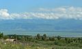
South shore of Lake Enriquillo, looking northward to the Sierra de Neiba mountains, Independencia Province, Dominican Republic (2007)

See also
 In Spanish: Provincia de Independencia para niños
