
Lake Enriquillo facts for kids
Quick facts for kids Enriquillo |
|
|---|---|
 |
|
| Location | western Dominican Republic |
| Coordinates | 18°30′N 71°35′W |
| Type | salt water lake |
| Basin countries | Dominican Republic |
| Surface area | 265 km² |
| Surface elevation | -44 m |
| Settlements | see list |

Lake Enriquillo is a large lake located in the western part of the Dominican Republic. It is very close to the border with Haiti.
Long ago, the native Taíno people called this lake Hagueygagon. Later, during the time when Europeans settled the area, it was known as Jaragua Lake.
The lake sits in a long valley called the Hoya de Enriquillo. This valley is surrounded by mountains. To the north, you'll find the "Sierra de Neiba" mountains. To the south, there are the "Sierra de Bahoruco" mountains.
Contents
About Lake Enriquillo
Lake Enriquillo covers an area of about 265 square kilometers (102 square miles). What makes it special is its elevation. The surface of the lake is about 44 meters (144 feet) below sea level. This makes it the lowest point in the entire Caribbean region!
The lake has three small islands. Their names are Isla Cabritos, Barbarita, and La Islita.
Only small rivers flow into Lake Enriquillo. Rivers coming from the Sierra de Neiba mountains usually have water all year round. However, rivers from the Sierra de Bahoruco mountains sometimes dry up.
Why is the lake salty?
Lake Enriquillo is a salt water lake. It's even saltier than the ocean! This happens because the rivers that feed the lake are small. Also, a lot of water from the lake evaporates into the air due to the warm climate. When water evaporates, the salt is left behind, making the remaining water saltier over time.
Animals and Plants
Many different kinds of birds come to Lake Enriquillo to find food. You might even spot beautiful flamingos here! The lake is also home to American crocodiles. Some fish like tilapia live in its waters too.
The area around the lake is quite dry. This means the vegetation isn't very thick. You'll mostly see cacti and small shrubs growing there.
The lake is an important natural area. It is part of the "Lago Enriquillo e Isla Cabritos National Park". It's also part of the "Jaragua - Bahoruco - Enriquillo Biosphere Reserve", which helps protect its unique environment.
Cities on the lake
Several towns and cities are located right on the coast of Lake Enriquillo, or very close by. These include:
- Villa Jaragua
- Postrer Río
- La Descubierta
- Boca de Cachón
- El Limón
- Vengan a Ver
Images for kids
-
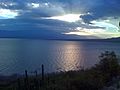
Lake Enriquillo seen from Las Caritas National Park, near La Descubierta
-
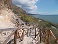
Las Caritas.
-
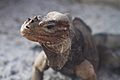
Rhinoceros iguana in Lake Enriquillo.


.jpg)
See also
 In Spanish: Lago Enriquillo para niños
