
Baoruco Province facts for kids
Quick facts for kids Baoruco |
||
| Province | ||
|
||
| Country | ||
|---|---|---|
| Development region | Enriquillo (VI) | |
| Capital | Neiba | |
| - elevation | 22 m (72 ft) | |
| - coordinates | 18°29′24″N 71°25′12″W / 18.49000°N 71.42000°W | |
| Area | 1,284.9 km² (496 sq mi) | |
| Population | 111,269 (2014) | |
| Density | 87 /km² (225 /sq mi) | |
| Province since | 1943 | |
| Subdivisions | 5 municipalities 9 municipal districts |
|
| Congresspersons | 1 Senator 2 Deputies |
|
| Timezone | EST (UTC-4) | |
| Area code | 1-809 1-829 1-849 | |
| ISO 3166-2 | DO-03 | |

Baoruco, also known as Bahoruco (but the "h" is silent!), is a Dominican province. It's located in the western part of the country, in a valley called Hoya de Enriquillo. The main city, or capital, is Neiba.
This province was created in 1943. Before that, it was part of the Barahona province. It was named Baoruco because the northern side of the Sierra de Bahoruco mountains used to be part of it. Later, when the Independencia province was formed, that mountain area became part of the new province. However, the name Baoruco stayed the same!
Contents
Where is Baoruco Located?
Baoruco province shares its borders with several other provinces. To the north, it's next to the San Juan province. To the east, you'll find the Azua and Barahona provinces. Finally, to the south and west, it borders the Independencia province.
 |
San Juan | Azua | |
|
| Independencia | Barahona | |||
| Independencia |
A Look at Baoruco's History
When Baoruco became a province in 1943, it included the municipalities of Neiba, Duvergé, La Descubierta, and Tamayo. But things changed in 1948. When the Independencia province was created, Duvergé and La Descubierta moved to that new province.
Over the years, more towns became part of Baoruco:
- Villa Jaragua joined in 1974.
- Galván became a municipality in 1997.
- Los Ríos was added in 2001.
The province also has smaller areas called municipal districts. These were created at different times:
- 1978: Uvilla
- 2001: El Palmar
- 2004: Santana, Montserrat, and Las Clavellinas
- 2005: Cabeza de Toro
- 2006: El Salado, Mena, and Santa Bárbara-El 6
Population of Baoruco
According to the last national count in 2014, about 111,269 people lived in Baoruco province. A large number, 69,360, lived in the towns and cities. This means the province has about 86.6 people per square kilometer.
Baoruco's population makes up about 1.2% of the total population of the Dominican Republic. It is the 23rd most populated province out of 31, plus the National District.
As of As of 2016[update], it's estimated that the province has around 99,607 residents. The biggest city in the province is Neiba, which is also its capital. In 2010, Neiba had a population of 27,105 people.
Geography and Landscape
Baoruco province covers a total area of about 1,284.9 km2 (496.1 sq mi). This is about 2.6% of the total area of the Dominican Republic. It ranks as the 17th largest province in the country.
The capital city, Neiba, is very close to sea level, with an altitude of only 13 m (43 ft).
The province is mostly located in the Hoya de Enriquillo valley. This valley is very dry, and some parts are even below sea level! The famous Lake Enriquillo is in this valley. About one-third of the lake's surface, including its small islands like Barbarita and Islita, belongs to Baoruco province.
In the northern part of the province, along the border with San Juan, you'll find the Sierra de Neiba mountains.
The most important river in Baoruco is the Yaque del Sur. It's one of the longest rivers in the country and forms the eastern border of the province. Its water is very important for irrigation to help crops grow. Other smaller rivers include Las Marías and Panzo.
The climate in Baoruco is tropical. It's usually very hot and dry in the valley areas. However, it gets cooler as you go up into the mountains. In the dry valley, you'll see many cacti and other plants that thrive in dry conditions. In the mountains, there are even some rainforests!
The main road in the province runs through the southern part, following the valley. Most of the important towns are located along this road.
Cities and Towns
Baoruco province has five main municipalities and nine smaller municipal districts. Here's a look at them:
| Municipality (code) | Municipal Districts (code) | Population (2010) |
Area (km2) |
Density | Altitude (m) |
|---|---|---|---|---|---|
| Neiba (030101) | 27,105 | 203.8 | 133.0 | 22 | |
| El Palmar (030102) | 9,406 | 78.5 | 119.8 | 11 | |
| Neiba (030100) | 36,511 | 282.3 | 129.3 | ||
| Galván (030201) | 13,217 | 156.0 | 84.7 | 54 | |
| El Salado (030202) | 2,485 | 125.5 | 19.8 | 5 | |
| Galván (030200) | 15,702 | 281.5 | 55.8 | ||
| Tamayo (030301) | 7,718 | 121.4 | 63.6 | 22 | |
| Uvilla (030302) | 2,991 | 2.3 | 1,300.4 | 12 | |
| Santana (030303) | 5,712 | 65.2 | 87.6 | 49 | |
| Monserrat (030304) | 3,312 | 16.5 | 200.7 | 19 | |
| Cabeza de Toro (030305) | 1,864 | 207.9 | 9.0 | 406 | |
| Mena (030306) | 2,395 | 6.8 | 352.2 | 15 | |
| Santa Bárbara-El 6 (030307) | 2,780 | 14.2 | 195.8 | 15 | |
| Tamayo (030300) | 26,772 | 434.3 | 61.6 | ||
| Villa Jaragua (030401) | 10,619 | 137.2 | 285.5 | 3 | |
| Villa Jaragua (030400) | 10,619 | 137.2 | 285.5 | ||
| Los Ríos (030501) | 5,771 | 101.0 | 57.1 | 35 | |
| Las Clavellinas (030502) | 1,938 | 48.4 | 40.0 | 177 | |
| Los Ríos (030500) | 7,709 | 149.5 | 51.6 | ||
| Baoruco province (030000) | 97,313 | 1,284.9 | 75.7 | ||
Economy and What They Produce
The main way people in Baoruco province make a living is through agriculture. This means growing crops! Some of the most important products are:
- Plantains: These are like bananas and are grown a lot in Tamayo.
- Grapes: You'll find many grape farms in Neiba and Los Ríos.
- Coffee and Beans: These are important crops grown in the Sierra de Neiba mountains.
Images for kids
-
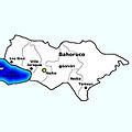
Municipalities of the Province.
-
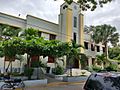
Municipal capital of Neiba.


See also
 In Spanish: Provincia de Bahoruco para niños
