
Barahona Province facts for kids
Quick facts for kids Barahona |
||
| Province | ||
|
||
| Country | ||
|---|---|---|
| Development region | Enriquillo (VI) | |
| Capital | Santa Cruz de Barahona | |
| - elevation | 47 m (154 ft) | |
| - coordinates | 18°12′30″N 71°06′0″W / 18.20833°N 71.10000°W | |
| Highest point | Loma Pie de Palo | |
| - location | Bahoruco Oriental, Sierra de Bahoruco | |
| - elevation | 1,603 m (5,259 ft) | |
| - coordinates | 18°07′34″N 71°10′00″W / 18.12599°N 71.16673°W | |
| Lowest point | Caribbean Sea | |
| - elevation | 0 m (0 ft) | |
| Area | 1,660.2 km² (641 sq mi) | |
| Population | 232,818 (2014) | |
| Density | 140 /km² (363 /sq mi) | |
| Province since | 1881 | |
| Subdivisions | 11 municipalities 11 municipal districts |
|
| Congresspersons | 1 Senator 7 Deputies |
|
| Timezone | EST (UTC-4) | |
| Area code | 1-809 1-829 1-849 | |
| ISO 3166-2 | DO-04 | |

Barahona is a province in the Dominican Republic. It is located in the southwestern part of the country. The main city and capital of Barahona is Santa Cruz de Barahona.
This area became a "Maritime District" on September 12, 1881. This was an old way to describe coastal regions. Later, in 1907, the Dominican Constitution changed these districts into provinces.
Contents
What's in a Name? The Origin of Barahona
The province gets its name from its capital city, Santa Cruz de Barahona. Barahona is a Spanish last name. It is thought that a Spanish colonist with this name once lived in the area.
Where is Barahona Located?
Barahona province is surrounded by other provinces and the sea. To its northwest is Baoruco. To the northeast, you'll find Azua. On its west side is Independencia. The Pedernales province is to the southwest and south. To the east, Barahona borders the beautiful Caribbean Sea.
 |
Baoruco | Azua province | |
|
| Independencia | Caribbean Sea | |||
| Pedernales | Pedernales |
A Look Back: Barahona's History
Barahona was once part of the larger Azua region. It became its own Maritime District on September 12, 1881. At that time, it included several towns like Santa Cruz de Barahona, Cabral, Duvergé, Enriquillo, and Neiba.
In 1907, the Dominican Constitution officially made it a province. Over time, two new provinces were formed from parts of Barahona. The Baoruco Province was created in 1943. Then, the Pedernales Province was formed in 1957.
Many towns in Barahona became official municipalities over the years. Cabral and Enriquillo have been municipalities since 1907. Other towns like Paraíso, Vicente Noble, Las Salinas, Polo, El Peñón, Fundación, La Ciénaga, and Jaquimeyes became municipalities later.
How Municipal Districts Were Formed
Smaller areas called municipal districts were also created. For example, Canoa became a district in 1996. El Cachón was added in 1999. Los Patos and Pescadería followed in 2001. Quita Coraza was created in 2003. Arroyo Dulce, Fondo Negro, Baoruco, and Palo Alto were added in 2004. La Guázara joined in 2006, and Villa Central in 2007.
People and Population in Barahona
| Population Growth | |
|---|---|
| Year | Population |
| 1920 | 48,120 |
| 1935 | 46,130 |
| 1950¹ | 62,166 |
| 1960² | 80,030 |
| 1970 | 111,162 |
| 1981 | 141,313 |
| 1993 | 164,835 |
| 2002 | 179,239 |
| 2010 | 187,105 |
| Note 1: Without Baoruco Province Note 2: Without Pedernales Province |
|
According to the last national census in 2014, Barahona province had 232,818 people. About 156,513 of these people lived in towns and cities. This means most people live in urban areas.
The population density (how many people live in each square kilometer) was about 140.2 people per square kilometer.
Barahona's population makes up about 2.46% of the country's total population. It is the 14th most populated province out of 31.
As of 2016, the estimated population for the province was 188,820 people. The largest city in the province is Santa Cruz de Barahona. In 2010, its population was 62,054 people.
Exploring Barahona's Geography
Barahona province covers an area of about 1,660.2 km2 (641.0 sq mi). This is about 3.6% of the Dominican Republic's total area. It is the 12th largest province in the country. The capital city, Santa Cruz de Barahona, is about 47 m (154 ft) above sea level.
The province has two main geographical areas. There is the valley of the Yaque del Sur river in the north. The other important area is the Sierra de Bahoruco (Bahoruco mountain range).
Most people live along the coast or near the Yaque del Sur river. This is because the Sierra de Bahoruco mountains reach the coast. Polo is the only town located high up in the mountains.
Mountains and Rivers
The eastern part of the Sierra de Neiba mountains is in the northwest of the province. The Sierra Martín García mountains form the border with the Azua Province in the northeast.
The Yaque del Sur river valley is a key farming area. Farmers use the river's water to grow crops. The main crops are plantains and sugar cane. The Rincón lake is also in this valley. Fishing is an important activity there.

The Sierra de Bahoruco covers the southern, central, and western parts of the province. The part of this mountain range in Barahona is called Bahoruco Oriental (Eastern Bahoruco). This area is special because it has rainforests. Winds from the Caribbean Sea bring a lot of rain to these mountains.
The highest mountain in Eastern Bahoruco is Pie de Palo, at 1,603 meters (about 5,259 feet). Other tall mountains include Trocha de Pey (1,476 m), La Torre (1,455 m), and Loma Remigio (1,287 m).
The most important river in the province is the Yaque del Sur. Other rivers include Nizaíto (23 km long) and Bahoruco (14 km long). The San Rafael river is only 3 km long. However, many people visit it in summer to enjoy its cool waters. Some of its water is also used by the city of Barahona.
Climate and Roads
The climate in Barahona is tropical. It is very hot and dry in the valley areas. But it is cooler in the mountains. In the dry valley, you can find cacti and other plants that like dry weather. The mountains of Bahoruco Oriental have rainforests because they get a lot of rain.
There are three important roads in the province. They all lead to the border with Haiti. One road goes from north to south through the province. It reaches Pedernales after crossing the Sierra de Bahoruco along the coast.
The other two roads go to Jimaní. They go around Lake Enriquillo. One road follows the northern side of the lake, and the other follows the southern side.
Understanding Barahona's Municipalities
Barahona province is divided into 11 municipalities and 11 municipal districts. These are like smaller local government areas. Here is a list of them:
| Municipality (code) | Municipal Districts (code) | Population (2010) |
Area (km2) |
Density | Altitude (m) |
|---|---|---|---|---|---|
| Santa Cruz de Barahona (040101) | 62,054 | 76.1 | 815.4 | 47 | |
| EL Cachón (040102) | 2,046 | 35.7 | 57.3 | 90 | |
| La Guázara (040103) | 1,892 | 52.6 | 36.0 | 458 | |
| Villa Central (040104) | 17,627 | 4.2 | 4,196.9 | 7 | |
| Santa Cruz de Barahona (040100) | 83,619 | 168.6 | 496.0 | ||
| Cabral (040201) | 14,823 | 121.6 | 121.9 | 34 | |
| Cabral (040200)) | 14,823 | 121.6 | 121.9 | ||
| Enriquillo (040301) | 10,620 | 76.3 | 139.2 | 67 | |
| Arroyo Dulce (040302) | 2,544 | 251.7 | 10.1 | 66 | |
| Enriquillo (040300) | 13,164 | 328.0 | 40.1 | ||
| Paraíso (040401) | 11,235 | 86.1 | 130.5 | 51 | |
| Los Patos (040402) | 4,155 | 50.1 | 82.9 | 1 | |
| Paraíso (040400) | 15,390 | 136.2 | 113.0 | ||
| Vicente Noble (040501) | 11,433 | 4.9 | 2,333.3 | 43 | |
| Canoa (040502) | 3,978 | 96.0 | 41.4 | 19 | |
| Quita Coraza (040503) | 2,794 | 75.4 | 37.1 | 106 | |
| Fondo Negro (040504) | 3,400 | 70.0 | 48.6 | 98 | |
| Vicente Noble (040500) | 21,605 | 246.3 | 87.7 | ||
| El Peñón (040601) | 3,970 | 41.8 | 95.0 | 13 | |
| El Peñón (040600) | 3,970 | 41.8 | 95.0 | ||
| La Ciénaga (040701) | 4,376 | 48.8 | 89.7 | 19 | |
| Baoruco (040702) | 4,736 | 68.0 | 69.6 | 19 | |
| La Ciénaga (040700) | 9,112 | 116.9 | 77.9 | ||
| Fundación (040801) | 3,414 | 17.9 | 190.7 | 6 | |
| Pescadería (040802) | 4,628 | 34.3 | 134.9 | 10 | |
| Fundación (040800) | 8,042 | 52.2 | 154.1 | ||
| Las Salinas (040901) | 4,703 | 126.6 | 37.1 | 34 | |
| Las Salinas (040900) | 4,703 | 126.6 | 37.1 | ||
| Polo (041001) | 8,186 | 206.7 | 39.6 | 713 | |
| Polo (041000) | 8,186 | 206.7 | 39.6 | ||
| Jaquimeyes (041101) | 3,530 | 105.7 | 33.4 | 17 | |
| Palo Alto (041102) | 961 | 9.5 | 101.2 | 16 | |
| Jaquimeyes (041100) | 4,491 | 115.3 | 39.0 | ||
| Barahona province (040000) | 187,105 | 1,660.2 | 112.7 | ||
Barahona's Economy: How People Make a Living
The main way people earn money in Barahona is through agriculture. In the mountains, coffee is a key crop. In the Yaque del Sur river valley, farmers mostly grow plantains and sugar cane.
Other important activities include industry in Santa Cruz de Barahona. Here, factories produce sugar and textiles (cloth). Fishing is also important along the Caribbean coast.
Related Pages
Images for kids
-
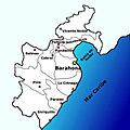
Municipalities of Barahona Province.
-
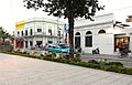
Barahona Dominican Republic downtown streets.


See also
 In Spanish: Provincia de Barahona para niños
