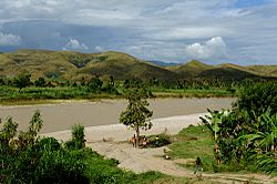
Artibonite River facts for kids
Quick facts for kids Artibonite |
|
| Artibonito, Latibonit | |
| River | |
| Countries | Dominican Republic, Haiti |
|---|---|
| Tributaries | |
| - left | Vallecito, Joca, Tocino, Macasía, Fer à Cheval |
| - right | Libón, Victorine, Guayamouc, Thomonde, Boucan Carré |
| Cities | Pedro Santana, Bánica, Mirebalais |
| Source | |
| - location | Cordillera Central, Dominican Republic |
| Mouth | |
| - location | Gulf of Gonâve, Haiti |
| - elevation | 0 m (0 ft) |
| - coordinates | 19°14′20″N 72°46′57″W / 19.23889°N 72.78250°W |
| Length | 321 km (199 mi) |
| Basin | 9,013 km² (3,480 sq mi) |
| Discharge | for Pedro Santana |
| - average | 16.6 m³/s (586 cu ft/s) |
The Artibonite River is a very important river on the island of Hispaniola. This island is shared by two countries: the Dominican Republic and Haiti. The river is also known as Artibonito in Spanish and Latibonit in Haitian Creole.
At 321 kilometers (about 200 miles) long, the Artibonite River is the longest river on the entire island. Most of its length, 253 kilometers, flows through Haiti. The remaining 68 kilometers are in the Dominican Republic.
Contents
What's in a Name?
The original people of Hispaniola, the Taínos, had their own name for this river. They called it Hatibonico.
Later, a writer named Peter Martyr d'Anghiera wrote about the river. He recorded its name as Attiboni or Attibonicus. Some people thought another river, the Guayajayuco, was the Artibonite. But the Guayajayuco is actually a smaller river that flows into the Artibonite.
Where Does the Artibonite River Flow?
The Artibonite River begins high up in the mountains. Its source is in the Cordillera Central mountain range. This is in the Dominican Republic, northeast of a place called Río Limpio.
The river then flows a long way across the island. It eventually reaches the sea in Haiti. The mouth of the river is south of La Grand Saline. Here, it empties into the Gulf of Gonâve.
The River as a Border
For some distance, the Artibonite River acts as a natural border. It separates the Dominican Republic from Haiti. This happens from the town of Pedro Santana until it meets the Macasías River. After that, it turns west and flows entirely into Haiti.
Understanding the River's Size
The area of land that drains into the Artibonite River is called its watershed. This watershed covers a huge area of 9,013 square kilometers (about 3,480 square miles). A large part of this watershed is in Haiti.
The river's discharge is how much water flows through it at a certain point. At Pedro Santana, about 16.6 cubic metres of water flow through the river every second. That's a lot of water!
What Rivers Join the Artibonite?
Smaller rivers that flow into a larger river are called tributaries. The Artibonite River has several important tributaries.
In the Dominican Republic, some of the most important ones are the Libón, Macasías, and Joca rivers. The Libón River is special because it's the only major tributary that joins the Artibonite from its right side.
How Does the Environment Affect the River?
Sadly, deforestation has caused problems for the Artibonite River. Deforestation means cutting down many trees. When trees are removed, the soil can wash away easily. This affects the quality and amount of water in the river.
There aren't many fish in the river anymore. Only tilapias are commonly caught. In the past, American crocodiles used to live in the Artibonite River. Now, these crocodiles are mostly found in the large lakes on the island.
How Do People Use the Artibonite River?
The water from the Artibonite River is very useful. In Haiti, it is used for irrigation. This means the water is directed to farms to help grow crops.
In the Dominican Republic, the river flows through high mountains. Because of this, it's not used as much for irrigation there.
An important structure on the river is the Peligre Hydroelectric Dam. This dam was built on the Artibonite River in Haiti. It helps to produce electricity for the country.
See also
 In Spanish: Río Artibonito para niños
 | Valerie Thomas |
 | Frederick McKinley Jones |
 | George Edward Alcorn Jr. |
 | Thomas Mensah |


