Pedro Santana, Dominican Republic facts for kids
Quick facts for kids
Pedro Santana
|
|
|---|---|

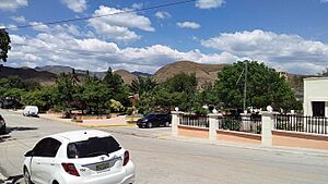
Street view of Pedro Santana, Elias Pina, Dominican Republic.
|
|
| Country | |
| Province | Elías Piña |
| Municipality since | 1952 |
| Area | |
| • Total | 575.02 km2 (222.02 sq mi) |
| Population
(2012)
|
|
| • Total | 4,875 |
| • Density | 8.4780/km2 (21.9578/sq mi) |
| Distance to – Comendador |
52 km |
| Municipalities | 1 |
Pedro Santana is a town in the Dominican Republic. It's located in the Elías Piña area, right near the border with Haiti.
This town is named after Pedro Santana, who was the very first president of the Dominican Republic. He was also an important general during the country's fight for independence.
History of Pedro Santana
For a long time, Pedro Santana was a part of the city of Banica.
Then, on March 3, 1952, a special law (Law No. 3208) was passed. This law changed Pedro Santana from just a district into its own municipality. A municipality is like a local government area.
Population Changes
In 2002, a count of the people (called a census) was done. It showed that 4,043 people lived in Pedro Santana.
- About 1,183 people lived in the town area (urban).
- About 2,860 people lived in the countryside (rural).
- There were 2,207 men and 1,836 women counted.
By 2012, the population had grown to 4,875 people.
Economy of the Town
The main way people in Pedro Santana make a living is through farming. This means that agriculture is the most important economic activity for the town.
See also
 In Spanish: Pedro Santana (municipio) para niños
 | Madam C. J. Walker |
 | Janet Emerson Bashen |
 | Annie Turnbo Malone |
 | Maggie L. Walker |


