
Mayagüez, Puerto Rico facts for kids
Quick facts for kids
Mayagüez
Municipio Autónomo de Mayagüez
Pueblo de Nuestra Señora de la Candelaria de Mayagüez
|
|||
|---|---|---|---|
| Autonomous Municipality of Mayaguez | |||
|
From top, left to right: Plaza Colón Square and cathedral; Yagüez Theater; University of Puerto Rico at Mayagüez; downtown Mayagüez; Old US Custom House; entrance portico to Próceres Park
|
|||
|
|||
| Nickname(s):
"La Sultana del Oeste", "La Ciudad de las Aguas Puras", "El Pueblo del Mangó"
|
|||
| Motto(s):
Nuevo Mundo dio Colon a Castilla y Leon
|
|||
| Anthem: "Mi patria es un oasis" | |||

Map of Puerto Rico highlighting Mayagüez Municipality
|
|||
| Sovereign state | United States | ||
| Commonwealth | Puerto Rico | ||
| Founded | September 18, 1760 | ||
| Founded by | Faustino Martínez de Matos Juan de Silva Juan de Aponte |
||
| Named for | Originally Virgin of Candelaria then local indigenous name variant. | ||
| Seat | Casa Alcaldia de Mayaguez | ||
| Barrios | |||
| Government | |||
| • Type | Mayor-council government | ||
| Area | |||
| • Municipality | 274.09 sq mi (709.89 km2) | ||
| • Land | 77.63 sq mi (201.07 km2) | ||
| • Water | 196.46 sq mi (508.82 km2) | ||
| Highest elevation | 1,577 ft (480.6 m) | ||
| Lowest elevation | 0 ft (0 m) | ||
| Population
(2020)
|
|||
| • Municipality | 73,077 | ||
| • Rank | 9th in Puerto Rico | ||
| • Density | 266.617/sq mi (102.9413/km2) | ||
| • Metro | 97,605 (MSA) | ||
| • CSA | 222,705 | ||
| Demonym(s) | Mayagüezanos | ||
| Time zone | UTC−4 (AST) | ||
| ZIP Codes |
00680, 00681, 00682
|
||
| Area code(s) | 787/939 | ||
| Major routes | |||
| GNIS feature ID | 1611495 | ||


Mayagüez (Spanish pronunciation: [maʝaˈɣwes], locally [maʝaˈweʔ]) is the ninth-largest city in Puerto Rico. It is located on the western coast of the island. Mayagüez was founded on September 18, 1760.
The city is also known by several nicknames. These include "La Sultana del Oeste" (The Sultaness of the West), "Ciudad de las Aguas Puras" (City of Pure Waters), and "Ciudad del Mangó" (Mango City). In 1894, the Spanish Crown gave it the special title of "Excellent City of Mayagüez" (Excelente Ciudad de Mayagüez).
Mayagüez has a population of about 73,077 people. It is the main city of the Mayagüez Metropolitan Statistical Area.
Contents
History of Mayagüez
The area where Mayagüez is located was once home to two Taíno chiefdoms. The Taíno were the main people living on the island when Europeans arrived in 1493. They called the island "Borikén" or "Borinquen." The Taíno people came from South America and lived in small villages. They were farmers who grew crops like pineapples and sweet potatoes. They also fished and gathered seafood.

Mayagüez was founded on September 18, 1760. A group led by Faustino and Lorenzo Martínez de Matos, Juan de Silva, and Juan de Aponte started the town. It was built on a hill about one kilometer from Mayagüez Bay. The town was named "Nuestra Señora de la Candelaria de Mayagüez" (Our Lady of Candelaria of Mayagüez). This name honored an appearance of the Virgin Mary on the island of Tenerife. Many of the first settlers came from the Canary Islands, where the Virgin of Candelaria is the patron saint.
In 1763, the Spanish Crown allowed the town to govern itself. This officially separated it from the larger area of San Germán. On May 7, 1836, Mayagüez became a royal town, called a villa. Rafael Mangual became its first mayor. At this time, farming was the main economic activity.
A famous Puerto Rican, Eugenio María de Hostos, was born in Mayagüez in 1839. He was an important educator, philosopher, and writer. On July 10, 1877, Mayagüez officially became a city by order of the Spanish Crown.
After the Spanish–American War in 1898, Puerto Rico became a territory of the United States. In 1899, a census showed that Mayagüez had a population of 35,700 people. This made it one of the largest towns in Puerto Rico.
The main Roman Catholic church, Our Lady of the Candelaria, was first built in 1780. The church standing today was built in 1836. It was rebuilt in 1922 after the 1918 San Fermín earthquake caused damage.
In 1911, the College of Agriculture and Mechanic Arts was founded in Mayagüez. Today, it is known as the University of Puerto Rico at Mayagüez (UPRM). It is a leading engineering school in the Caribbean.

From 1962 to 1998, Mayagüez was a big center for canning and processing tuna. At one point, a large part of the tuna eaten in the United States came from Mayagüez. The city was also important for the textile industry. Many uniforms for the United States Army were sewn here.
Today, Mayagüez is the fifth-largest city in Puerto Rico. It is considered one of the most important cities on the island. The city's main square is Plaza Colón, which honors Christopher Columbus. His statue stands in the middle of the square.
Mayagüez has become a major college town. This is because of universities like the UPRM and the Pontifical Catholic University of Puerto Rico.
On September 20, 2017, Hurricane Maria hit Puerto Rico. The storm caused many landslides in Mayagüez.
Geography and Climate
Mayagüez is located near the middle of Puerto Rico's west coast. It takes about two to three hours to drive there from San Juan. The city covers 77.6 square miles (201.06 km²). Its landscape includes coastal plains, river valleys, marshlands, hills, and mountains.
Two important rivers flow through Mayagüez. The Río Yagüez flows from the Central Mountain Range through downtown. It then empties into the Mona Passage. The Río Guanajibo flows through the southern part of the city and also empties into the Mona Passage.
Protected Natural Areas
The Desecheo National Wildlife Refuge is on Desecheo Island. This is a protected area.
North of the El Maní community in Mayagüez is the Boquilla Creek Wildlife Reserve. This protected area is home to endangered species.
Weather in Mayagüez
Mayagüez has a tropical savanna climate. This means it is usually warm all year. The average yearly temperature is about 75°F (24°C). Winters are generally dry and warm, with temperatures between 55°F (13°C) and 82°F (28°C). Summers are hot and humid, with temperatures reaching 95°F (35°C). The heat can feel even higher, up to 115°F (46°C).
From May to October, strong thunderstorms often happen in the evenings. These storms can bring strong winds, floods, and sometimes even hail or tornadoes.
| Climate data for Mayagüez, Puerto Rico (1991-2020 normals, extremes 1900-present) | |||||||||||||
|---|---|---|---|---|---|---|---|---|---|---|---|---|---|
| Month | Jan | Feb | Mar | Apr | May | Jun | Jul | Aug | Sep | Oct | Nov | Dec | Year |
| Record high °F (°C) | 99 (37) |
96 (36) |
97 (36) |
98 (37) |
98 (37) |
98 (37) |
98 (37) |
99 (37) |
99 (37) |
102 (39) |
98 (37) |
96 (36) |
102 (39) |
| Mean daily maximum °F (°C) | 85.0 (29.4) |
85.7 (29.8) |
86.8 (30.4) |
87.2 (30.7) |
88.5 (31.4) |
90.2 (32.3) |
90.0 (32.2) |
90.2 (32.3) |
90.1 (32.3) |
89.8 (32.1) |
88.2 (31.2) |
86.1 (30.1) |
88.1 (31.2) |
| Daily mean °F (°C) | 76.3 (24.6) |
76.3 (24.6) |
77.2 (25.1) |
78.0 (25.6) |
79.7 (26.5) |
80.5 (26.9) |
81.3 (27.4) |
81.3 (27.4) |
81.2 (27.3) |
81.2 (27.3) |
79.7 (26.5) |
77.6 (25.3) |
79.2 (26.2) |
| Mean daily minimum °F (°C) | 67.6 (19.8) |
66.9 (19.4) |
67.6 (19.8) |
68.9 (20.5) |
71.0 (21.7) |
70.8 (21.6) |
72.6 (22.6) |
72.4 (22.4) |
72.3 (22.4) |
72.5 (22.5) |
71.3 (21.8) |
69.0 (20.6) |
70.2 (21.2) |
| Record low °F (°C) | 51 (11) |
43 (6) |
50 (10) |
57 (14) |
57 (14) |
60 (16) |
58 (14) |
58 (14) |
59 (15) |
61 (16) |
59 (15) |
55 (13) |
43 (6) |
| Average rainfall inches (mm) | 1.19 (30) |
1.81 (46) |
2.08 (53) |
3.88 (99) |
6.00 (152) |
5.15 (131) |
5.81 (148) |
6.80 (173) |
6.64 (169) |
6.49 (165) |
3.08 (78) |
2.33 (59) |
51.26 (1,302) |
| Average rainy days (≥ 0.01 in) | 4.9 | 6.6 | 7.5 | 10.8 | 11.0 | 12.0 | 13.4 | 14.8 | 15.1 | 13.6 | 9.0 | 6.4 | 125.1 |
| Source: NOAA | |||||||||||||
City Layout and Neighborhoods


Mayagüez is divided into 21 main areas called barrios. These include Mayagüez Pueblo, which is the downtown area and the city's administrative center. One of the barrios is Isla de Mona e Islote Monito. This barrio includes the islands of Mona Island and Monito Island. It is the largest barrio by land area but has no permanent residents. Desecheo Island also belongs to Mayagüez, as part of the Sabanetas barrio.
Main Barrios of Mayagüez
Mayagüez Pueblo is further divided into these smaller areas:
- Candelaria
- Cárcel
- Marina Septentrional
- Marina Meridional
- Río
- Salud
City Sectors and Communities
Barrios are also divided into smaller areas called sectores (sectors). These can be different types, like urbanización (housing developments) or barriada (neighborhoods).
Some of the sectors that make up Mayagüez City are:
- Balboa
- Barcelona
- El Seco
- El Liceo
- El Pueblo
- La Mineral
- La Quinta
- París
- Trastalleres
Other well-known neighborhoods or sectors include:
- El Maní – a community in Sabanetas.
- Mayagüez Terrace – a housing development near the UPRM Campus.
- El Cerro de las Mesas – known for being home to "CROEM" and for great city views.
- Buena Vista – a scenic hilltop community next to the downtown area.
- Dulces Labios – a community along PR-2 known for its history and music.
- Ensanche Martínez (La Bosque) – a student area near the UPRM Campus.
- Ensanche Ramírez – a high-class hilltop development near the UPRM Campus.
Special Communities Program
Puerto Rico has a program called Comunidades Especiales de Puerto Rico (Special Communities of Puerto Rico). These are communities that receive extra support to improve living conditions. In Mayagüez, several barrios and neighborhoods are part of this program, including Balboa, Barrio Salud, Buena Vista, Dulces Labios, El Maní, and Trastalleres.
Population and People
| Historical population | ||
|---|---|---|
| Year | Pop. | ±% |
| 1772 | 1,800 | — |
| 1782 | 1,791 | −0.5% |
| 1797 | 2,210 | +23.4% |
| 1828 | 18,267 | +726.6% |
| 1836 | 19,356 | +6.0% |
| 1877 | 26,446 | +36.6% |
| 1899 | 38,915 | +47.1% |
| 1910 | 42,429 | +9.0% |
| 1920 | 41,612 | −1.9% |
| 1930 | 58,270 | +40.0% |
| 1940 | 76,487 | +31.3% |
| 1950 | 87,307 | +14.1% |
| 1960 | 83,850 | −4.0% |
| 1970 | 85,857 | +2.4% |
| 1980 | 96,193 | +12.0% |
| 1990 | 100,371 | +4.3% |
| 2000 | 98,434 | −1.9% |
| 2010 | 89,080 | −9.5% |
| 2020 | 73,077 | −18.0% |
In 2020, Mayagüez had a population of 73,077 people. The city also has many college students, adding about 10,000 to 15,000 people to the population each year. Most people in Mayagüez are of Hispanic or Latino origin.
In 2007, about 38.6% of households were married couples. About 33.3% of households had children under 18 living in them. The average household had 2.75 people. The median age in Mayagüez was 33 years old. For every 100 females, there were about 88.4 males.
In 2000, about 15.14% of the population spoke English as their first language.
| Mayagüez 2020 Census | ||
|---|---|---|
| Race | Population | % |
| White | 14,372 | 19.7 |
| Black | 3,331 | 4.6 |
| American Indian and Alaska Native | 306 | 0.4 |
| Asian | 102 | 0.1 |
| Native Hawaiian/Pacific Islander | 24 | 0.0 |
| Some other race | 16,878 | 23.1 |
| Two or more races | 38,064 | 52.1 |
Economy and Industry
Mayagüez has faced economic challenges over the years. The city once had large textile factories and a big tuna industry. These industries provided many jobs for a long time. However, during the 1990s, these factories closed down. This caused a significant loss of jobs in the city.
Even with these changes, Mayagüez's universities bring many students to the city. This student population helps the local economy. In recent years, new companies have moved into the city's industrial park. For example, in 2005, Winston-Salem Industries for The Blind opened. In 2007, Honeywell opened a customer support center.
Culture and Traditions
Mayagüez has made many contributions to Puerto Rican food. The city is known for its many mango trees. It is also home to several food businesses that are popular across Puerto Rico.
Popular Foods from Mayagüez
- Brazo gitano – This is a local version of the Swiss or jelly roll. E. Franco & Co. and Ricomini Bakery are famous for making them.
- Papalaya – A Latin-American food truck chain known for its "nachos with grated cheese, pico de gallo and special sauce."
- Sangría de Fido – This is a special drink made with fruit juices, rum, and burgundy wine. It is very popular and has a reputation outside Puerto Rico.
- India / Medalla beer – The only mass-produced Puerto Rican beer is brewed by "Cervecería India" in Mayagüez. The company's whistle signals different times of the day for the city.
- Rex Cream's Ice Cream – This ice cream chain started in the 1960s. Their stores in Mayagüez are famous for unique flavors, like corn sherbet.
- Tuna fish – Mayagüez was once a major center for tuna canning.
The city was also a big producer of rum from the 1930s to the 1970s. A new distillery, Destilería Coquí, started in Mayagüez in 2009. It makes artisan rum called pitorro.
Festivals and Events
Mayagüez celebrates its patron saint festival in late January or early February. This festival, called "Fiestas Patronales Virgen de la Candelaria", includes parades, games, local crafts, food, and live music.
Other fun events and festivals in Mayagüez include:
- Three Kings Day Festival – in January
- Romance on the Boulevard – in February
- Bomba and plena festival – in February or March
- Mothers Day concert – in May
- Fathers Day concert – in June
- Mayagüez Carnival – in May
- Danza Festival – in May
- Celebration of the founding of Mayagüez – in September
- Crafts fair – in November
- Christmas festivities – in December
- Anniversary of the Puerto Rican flag – in December
- Pedestrian Mayagüez at Plaza Colon – on the third Sunday of each month
Sports in Mayagüez

Mayagüez hosted the 2010 Central American and Caribbean Games. For these games, new stadiums were built, including a rebuilt Isidoro García Baseball Stadium and a new track and field and soccer stadium. Mayagüez also hosted the 2011 Caribbean Series in baseball.
The city has professional sports teams. The Indios de Mayagüez are the professional basketball team. The Indios de Mayagüez are also the city's baseball team. Both teams are named to honor the city's Taíno heritage. The professional soccer club Puerto Rico Sol plays in Mayagüez. The professional volleyball team Indias de Mayagüez also plays here.
The "Justas," which are inter-university games for Puerto Rico, were held in Mayagüez in 2010, 2016, and 2017.
Tourism and Landmarks
Mayagüez has 13 beaches to enjoy.
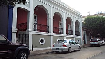
Important Places to Visit
- Centro Cultural Baudilio Vega Berríos (Municipal Cultural Center)
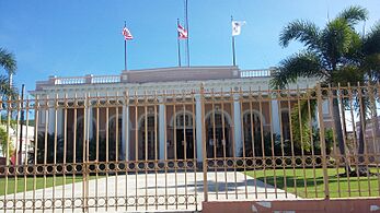
- Casa Consistorial De Mayagüez (City Hall)
- Plaza Colón – the main city square
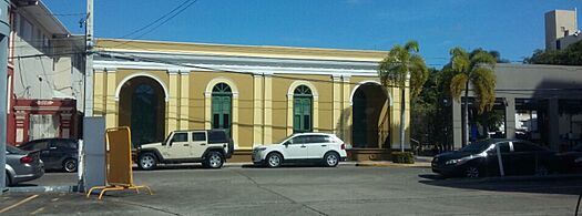
- Customs House
- Parque del Litoral Israel "Shorty" Castro (Coastal Park)
- Eugenio María de Hostos Monument
- Hostos Museum at Río Cañas Arriba barrio
- José de Diego Park
- Mayagüez Children's Library
- Mayagüez Mall
- Mayagüez Resort & Casino
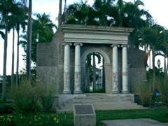
- Parque de los Próceres (Notable's Park)
- Parque Infantil del Milenio (Millennium Child Park)
- Tropical Agricultural Research Station
- Teatro Yagüez (Yaguez Theater/Municipal Theater)
- University of Puerto Rico at Mayagüez (El Colegio)
- RUM Planetarium
- RUM General Library
- Teatro Balboa (Second Municipal Theater)
=Images for kids
-
Customs House in Marina sector. Register of Historic Places
-
Museum House of Pilar Defilló (mother of Pablo Casals)
-
Entrance to the House Museum of Pilar Defilló
-
Casa Grande museum at Mendez Vigo Street
-
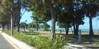
Parque del Litoral
-
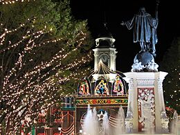
Plaza Colón with City Hall on background, Christmas 2006
-
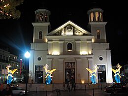
Nuestra Señora de la Candelaria Cathedral, Christmas 2006
-
University of Puerto Rico, Mayagüez – Portico


.jpg)


City Symbols
Mayagüez has an official flag and a coat of arms that represent the city.
Mayagüez Flag
The flag of Mayagüez has a wide cross. This cross represents Christianity, which was brought to the New World by Christopher Columbus. The blue and white waves on the flag represent the ocean, especially the Mona Passage. This is the sea Columbus sailed to reach these lands. The waves also symbolize the Yagüez River and the city's nickname, "City of Pure Waters." The red and white flames on the flag stand for the traditional bonfires lit during the "Day of Our Lady of Candelaria." This tradition honors the city's patron saint. The flag was officially adopted on December 3, 1996.
Mayagüez Coat of Arms
The original coat of arms for Mayagüez was given to the city on December 19, 1894. The top part of the coat of arms reminds us of Columbus's discovery of Puerto Rico in 1493. The bottom part shows a picture of Columbus landing on Puerto Rico's western coast. This is where rivers, including the Yagüez River, flow into the Mona Passage. The name Mayagüez comes from the Yagüez River.
City Anthem
The official song of Mayagüez was written by Luciano Quiñones. Before this song, the plena "A Mayagüez" was often used as the unofficial city song. Quiñones' song is a danza (a type of music). It talks about the symbols of Mayagüez, like its nicknames, its patron saint, the taste of mango, and its beautiful sunsets. It also mentions the Taíno people and Eugenio María de Hostos. The anthem was first performed on September 18, 1999, to celebrate the city's founding. It became the official anthem on December 20, 1999.
Education in Mayagüez

Mayagüez is an important city for education, with several colleges and universities.
Public Schools
The Residential Center for Educative Opportunities of Mayagüez (CROEM) is one of only two public boarding schools in Puerto Rico. The largest public high school is Eugenio María de Hostos High School. Another public high school is Dr. Pedro Perea Fajardo Vocational High School.
Private Schools
Some private schools in Mayagüez include:
- Southwestern Community School (SESO)
- Colegio San Benito
- Academia de la Inmaculada Concepción
- Colegio De La Milagrosa
- Academia Adventista del Oeste
- Theopolis Christian Academy (TCA)
Colleges and Universities
Mayagüez is a major college town because of these higher learning institutions:
- University of Puerto Rico at Mayagüez
- Pontifical Catholic University of Puerto Rico at Mayagüez
- Antillean Adventist University
- Carlos Albizu University
There are also several junior colleges:
- Instituto Comercial de Puerto Rico Junior College
- Instituto de Banca y Comercio
- NUC University
- Escuela Hotelera de San Juan - Recinto de Mayagüez
Transportation
_alturas,_Mayag%C3%BCez.jpg)
Most people in Puerto Rico travel by car. Mayagüez is connected to other parts of the island by two main highways.
Puerto Rico Highway 2 is a major road that links Mayagüez to Ponce in the south and Aguadilla and Arecibo to the north. Part of PR-2 is being made into a faster freeway.
Another important road is PR-102. It starts near Mayagüez Pueblo and runs along the city's coastal areas. The part of this highway near the Isidoro García Stadium was improved for the 2010 Central American and Caribbean Games.
There are 41 bridges in Mayagüez.
Public Transportation Options

Public transportation in Mayagüez includes a trolley service and private taxi companies. There is also a daytime público service called Mayagüez Urbano. This service provides transportation between main points in the city.
The city runs three trolleys that are free to use. They shuttle people between the downtown area and the Palacio de Recreación y Deportes. The University of Puerto Rico at Mayagüez (UPRM) also has its own trolley system for students.

For the 2010 Central American and Caribbean Games, an express bus system was set up. It used buses from San Juan's Metropolitan Bus Authority. This system helped transport passengers along Highway 2 and other main roads. Although it stopped after the games, it is expected to start again.
Mayagüez Seaport

The Port of Mayagüez is the third busiest port in Puerto Rico. It used to be a major base for tuna and fish companies. The port is about 3.8 miles (6.1 km) long. Its main channel is 0.4 miles (0.64 km) wide. The port is protected from rough seas by reefs.
In 2011, a new ferry service started from Mayagüez to the Dominican Republic. The city government has plans to develop the port further.
Eugenio María de Hostos Airport
Mayagüez's airport is called Eugenio María de Hostos Airport. It is also known as El Maní Airport. The airport is located about 4 miles (6.4 km) north of the city center. It has had regular airline services for over thirty years. Before it opened in 1955, it was a military base. Currently, Cape Air offers daily flights to San Juan.
Notable People from Mayagüez
.jpg)
Many famous people have come from Mayagüez, including:
- Wilkins – a Puerto Rican pop music singer and composer.
- Maria Arrillaga – a Puerto Rican poet and professor.
- J. J. Barea – a former professional basketball player.
- Lucy Boscana – an actress and a pioneer in Puerto Rico's television.
- Eugenio María de Hostos – a famous educator, philosopher, and writer.
- Keylla Hernández – a well-known TV personality.
- Alicia Moreda – an actress and comedian.
- Frankie Ruiz – a famous American salsa singer.
- Roberto Roena – a well-known salsa musician.
- Roberto Sanchez Vilella – a former Governor of Puerto Rico.
- José E. Serrano – a U.S. Congressman.
- Rawy Torres – a singer and composer, who was a member of the boy band Menudo.
International Connections
Mayagüez hosts two foreign consulates that serve Puerto Rico:
- Dominican Republic
- Hungary (Honorary Consulate)
Sister Cities
Mayagüez has sister cities, which are cities that share cultural or economic ties:
 Quiroga, Michoacán, Mexico
 Cartagena, Colombia
See also
 In Spanish: Mayagüez para niños
