Isla de Mona e Islote Monito, Mayagüez, Puerto Rico facts for kids
Quick facts for kids
Isla de Mona e Islote Monito
|
|
|---|---|
|
Barrio
|
|

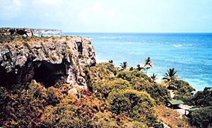
Playa Pájaros in Mona Island
|
|

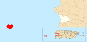
Location of Isla de Mona e Islote Monito within the municipality of Mayagüez shown in red
|
|
| Commonwealth | |
| Municipality | |
| Area | |
| • Total | 30.11 sq mi (78.0 km2) |
| • Land | 21.98 sq mi (56.9 km2) |
| • Water | 8.13 sq mi (21.1 km2) |
| Elevation | 197 ft (60 m) |
| Population
(2010)
|
|
| • Total | 5 |
| • Density | .2/sq mi (0.08/km2) |
| 2010 census | |
| Time zone | UTC−4 (AST) |
Isla de Mona e Islote Monito is a special island area, or "barrio," that belongs to Mayagüez, Puerto Rico. It's made up of two islands: Mona Island and the much smaller Monito Island. Even though it's a big area of land, not many people live there. In 2010, only five people were counted living on these islands!
These islands are the largest part of Mayagüez by land area. Together, Mona and Monito cover about 56.93 square kilometers. That's almost 28.3 percent of all the land in the municipality of Mayagüez. The islands are surrounded by the Mona Passage, which is a strait connecting the Atlantic Ocean and the Caribbean Sea. You can also find the Mona Island Lighthouse here.
| Historical population | |||
|---|---|---|---|
| Census | Pop. | %± | |
| 1900 | 6 | — | |
| 1910 | 28 | 366.7% | |
| 1920 | 35 | 25.0% | |
| 1930 | 35 | 0.0% | |
| 1940 | 156 | 345.7% | |
| 1950 | 3 | −98.1% | |
| 1960 | 0 | −100.0% | |
| 1970 | 6 | — | |
| 1980 | 0 | −100.0% | |
| 1990 | 0 | — | |
| 2000 | 0 | — | |
| 2010 | 5 | — | |
| U.S. Decennial Census 1899 (shown as 1900) 1910-1930 1930-1950 1980-2000 2010 |
|||
A Look at Their History
For a long time, Isla de Mona and Islote Monito were part of Spain. They were listed in Spain's official maps and records. However, things changed after the Spanish–American War in 1898.
Becoming Part of the United States
After the war, Spain and the United States signed a peace agreement called the Treaty of Paris of 1898. As a result of this treaty, Puerto Rico, including Mona and Monito islands, became a territory of the United States. This means they are governed by the U.S. but are not a state.
In 1899, the United States government did a count of the people in Puerto Rico. This count, called a census, found that only 6 people were living on Mona Island at that time.
See also
 In Spanish: Isla de Mona e Islote Monito (Mayagüez) para niños
 | John T. Biggers |
 | Thomas Blackshear |
 | Mark Bradford |
 | Beverly Buchanan |


