Mona Passage facts for kids
Quick facts for kids Mona Passage |
|
|---|---|
| Canal de la Mona | |

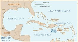
Location of the Mona Passage.
|
|
| Coordinates | 18°30′N 67°53′W / 18.500°N 67.883°W |
| Basin countries | Puerto Rico Dominican Republic |
The Mona Passage (also called Canal de la Mona in Spanish) is a narrow stretch of ocean. It acts like a watery highway between the large island of Hispaniola and Puerto Rico. This passage connects the Atlantic Ocean to the Caribbean Sea. It is a very important path for ships traveling between the Atlantic and the famous Panama Canal.
The Mona Passage is about 80 miles (130 kilometers) long. It can be a tricky place for ships because of strong, changing ocean currents. These currents are caused by the large islands on either side and by underwater sandbanks.
Contents
Islands of the Mona Passage
There are three smaller islands located within the Mona Passage. These islands are interesting spots in the middle of this busy waterway.
- Mona Island is the largest of the three. It sits almost in the middle of the Mona Passage.
- Monito Island is much smaller than Mona Island. It is located about three miles (five kilometers) northwest of Mona Island.
- Desecheo Island is about 30 miles (50 kilometers) northeast of Mona Island. It is much closer to the main island of Puerto Rico, only about 13 miles (21 kilometers) away.
Why is the Mona Passage so Active?
The Mona Passage is a place where the Earth's crust is very active. This means it often experiences small earthquakes. It was also the site of a very strong earthquake in 1918. This earthquake caused a huge ocean wave, called a tsunami, that hit western Puerto Rico.
The passage lies over a special area called a rift zone. This is where the Earth's plates are slowly pulling apart. Desecheo Island sits on a ridge that extends from Puerto Rico. This ridge forms the southern edge of a very deep underwater valley called the Mona Canyon. This canyon is about 13,123 feet (4,000 meters) deep.
How Ocean Water Moves Through the Passage
The Mona Passage is like a big doorway for ocean water. It allows water to flow between the Atlantic Ocean and the Caribbean Sea. This flow happens over an underwater ridge, or "sill," that is about 1,312 to 1,640 feet (400 to 500 meters) deep. This sill runs from northwest to southeast across the passage.
Water Layers and Flow
The water in the Mona Passage moves in two main layers.
- The top layer, which goes down to about 984 feet (300 meters), carries water from the Atlantic Ocean into the Caribbean Sea. This includes different types of water like Caribbean Surface Water and Sargasso Sea Water.
- Below this, the deeper layer of water flows in the opposite direction, from the Caribbean Sea back towards the Atlantic Ocean.
Tides and Waves
The regular rise and fall of the ocean, called tides, move through the Mona Passage from northeast to southwest. The main lunar tide, known as the M2 tide, causes most of the water movement. The currents from this tide often spin in a clockwise direction and move mostly north and south.
Sometimes, these strong tidal currents hit an underwater ridge called El Pichincho. When this happens, they can create special waves called internal tides. These are waves that move within the ocean, not on the surface. They can be quite tall, up to 131 feet (40 meters) high! As these internal tides travel south into the Caribbean Sea, they slowly lose their energy.
Nutrients and Ocean Life
When these internal tides break apart, they can cause the water to mix a lot. This mixing brings important nutrients, like nitrate, from deeper parts of the ocean up to the surface. The surface layer of the ocean, called the photic zone, is where sunlight can reach. These nutrients help tiny ocean plants, called phytoplankton, to grow. This growth is called "new production" and it supports the entire ocean food web.
Scientists have observed that there is more plant growth near the lowest part of these internal waves. This can even be more growth than what happens during the brightest part of the day when the sun is strongest.
Surface Waves and Solitons
Satellites and photos from the International Space Station have shown interesting patterns on the surface of the Mona Passage. These patterns are caused by groups of special waves called solitons (or nonlinear internal waves). These solitons are created at another underwater bank called Banco Engaño, located on the northwest side of the passage.
Depending on the direction of the ocean currents, these groups of waves can travel either into the Caribbean Sea or into the Atlantic Ocean.
All these different movements—surface tides, internal tides, solitons, and the general flow of water—make the Mona Passage a very active and important part of the ocean.
See also
- Battle of the Mona Passage
- Bays of the Mona Passage
- Mayagüez Bay
- Samaná Bay
- Scottish Bay
- Mona Canyon
- Old Bahama Channel
 In Spanish: Canal de la Mona para niños
 | Charles R. Drew |
 | Benjamin Banneker |
 | Jane C. Wright |
 | Roger Arliner Young |


