Maragüez facts for kids
Quick facts for kids
Maragüez
|
|
|---|---|

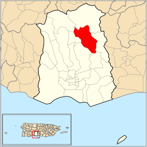
Location of barrio Maragüez within the municipality of Ponce shown in red
|
|
| Commonwealth | |
| Municipality | |
| Area | |
| • Total | 6.40 sq mi (16.6 km2) |
| • Land | 5.34 sq mi (13.8 km2) |
| • Water | 1.06 sq mi (2.7 km2) |
| Elevation | 774 ft (236 m) |
| Population
(2010)
|
|
| • Total | 545 |
| • Density | 102.1/sq mi (39.4/km2) |
| Source: 2010 Census | |
| Time zone | UTC−04:00 (AST) |
Maragüez is one of 31 special areas, or barrios, in the municipality of Ponce, Puerto Rico. It is a countryside area, not part of the main city. Maragüez is one of eight such rural areas in Ponce. Its name comes from the native people who lived there long ago. This barrio was officially created in 1878.
Contents
Where is Maragüez Located?
Maragüez is a rural barrio. It is found in the northeastern part of the Ponce municipality. This means it is northeast of the main city of Ponce.
Neighboring Areas
Maragüez shares its borders with several other barrios. To the north, it meets Anón and San Patricio. To the south, it borders Cerrillos. On its west side are Monte Llano and Machuelo Arriba. Finally, to the east, it touches Anón and Real.
The Río Cerrillos river flows through a large part of Maragüez. Locals sometimes call it the Rio Maragüez.
Facts About Maragüez
In 1920, about 616 people lived in Maragüez. By the year 2000, the population had grown to 754 people. This made it one of the least populated barrios in Ponce.
In 2010, the population was 545 people. This means there were about 102 people for every square mile. The main road that goes through Maragüez is PR-139.
Highest Points
The highest point in Maragüez is 2,132 feet tall. It is located at the very northeast tip of the barrio. Another important land feature is Cerro Santo Domingo. This hill stands at 2,004 feet high.
Important Landmarks
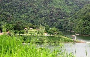
The Cerrillos Dam is a notable landmark in Maragüez. It is built over the Río Cerrillos river. Also, Cerrillos Lake is located within the Maragüez barrio.
See also
 In Spanish: Maragüez (Ponce) para niños
- List of communities in Puerto Rico
 | Janet Taylor Pickett |
 | Synthia Saint James |
 | Howardena Pindell |
 | Faith Ringgold |


