Real, Ponce, Puerto Rico facts for kids
Quick facts for kids
Real
|
|
|---|---|

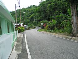
A section of rural Barrio Real in Ponce, Puerto Rico, along Route PR-511.
|
|

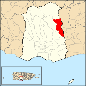
Location of barrio Real within the municipality of Ponce shown in red
|
|
| Commonwealth | |
| Municipality | |
| Area | |
| • Total | 5.27 sq mi (13.6 km2) |
| • Land | 5.22 sq mi (13.5 km2) |
| • Water | 0.05 sq mi (0.1 km2) |
| Elevation | 469 ft (143 m) |
| Population
(2010)
|
|
| • Total | 3,696 |
| • Density | 708/sq mi (273/km2) |
| Source: 2010 Census | |
Real is a special place in Ponce, Puerto Rico. It is one of the 31 areas called "barrios" in the city. Real is a rural barrio, meaning it's more like the countryside. It was started a long time ago, in 1878. Real is one of nine barrios in Ponce that share a border with another town. It touches the town of Juana Díaz.
Contents
Where is Real Located?
Real is a rural barrio found in the eastern part of Ponce. It is located northeast of the main city area. The name "Real" comes from a place called "Criadero Real." This was a barn and a place where cattle were raised and prepared for food.
What are Real's Borders?
Real has natural borders like hills and rivers. To the north, it's bordered by hills near La Compuesta street. To the south, it's bordered by the Río Inabon river. The west side is bordered by hills and parts of the Inabon River, as well as some lakes. The east side is bordered by Agustinillo Hill and other hills.
Real also borders other barrios and towns. To the north, it touches Anón barrio and parts of Juana Díaz. To the south, it borders Cerrillos and Coto Laurel. To the west, it borders Cerrillos and Maragüez. The eastern side of Real borders the municipality of Juana Díaz.
People and Features of Real

Real covers about 5.3 square miles of land. In 2000, about 3,139 people lived there. This meant there were about 596 people for every square mile. By 2010, the population grew to 3,696 people. The number of people per square mile also increased to 708.
Several communities are part of Barrio Real. These include Las Mesas, Ponton, Real Arriba, and Real Abajo. Other communities are Haciendas del Real, Mandry, Estancias del Real, and Sombras del Real. There's also a small area called "Anon" within Barrio Real, but it's not the same as the larger Anón barrio.
The main road that goes through Real is PR-511. Another road, PR-14, briefly touches the southern edge of the barrio. The highest point in Barrio Real is a hill called Cerro Agustinillo, which is 1,906 feet tall.
Important Places in Real
One important natural feature in Real is Vista Alegre Lake.
See also
 In Spanish: Real (Ponce) para niños
- List of communities in Puerto Rico
 | Kyle Baker |
 | Joseph Yoakum |
 | Laura Wheeler Waring |
 | Henry Ossawa Tanner |

